The Bromley Transport Action Plan sets priorities to make Bromley neighbourhood streets safer and more accessible for all.
In 2025, we completed work on Keighleys and Bromley roads
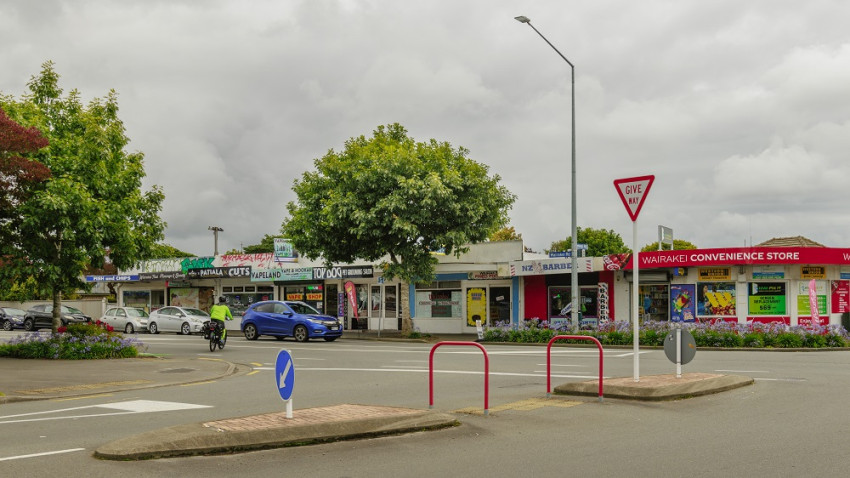
The 2025 upgrades included new speed humps, new signage, renewed asphalt in five areas near pedestrian crossings, tactile paving at six crossing points, one new pedestrian refuge island, and refreshed line markings across six work areas in Bromley.
We also improved street lighting in the area by:
- Upgrading the seven existing streetlights.
- Installing four new streetlights near key crossings, Bromley School and the Bromley Community Centre.
Read our Newsline(external link) story for more information.
These upgrades were part of the first phase of delivering the Bromley Transport Action Plan [PDF, 76 KB].
Bromley residents have raised concerns about fast, heavy traffic in the area, particularly on Keighleys Road and Bromley Road. In response, Council staff have worked alongside elected members and the community to identify how streets in the Bromley area could be improved.
The 2025/2026 Annual Plan includes funding for the next phase of work to improve streets in the Bromley area, including Hay Street. Some of this funding can be used quickly to address known issues and put in place improvements that have been previously approved.
How the rest of the funding is spent will require input from the community on their priorities. We’ll be going out for consultation throughout 2026 to get feedback from people on our plans.
Further background information about this work can be found in the sections below.
Residents of the east Christchurch suburb of Bromley have told us of problems caused by traffic in the area. This action plan reflects the issues reported by the community, proposes a range of solutions and sets priorities to make the neighbourhood streets safer for all who use them.
Addressing these issues has been a priority for the Waitai Coastal-Burwood-Linwood Community Board, which states:
“The community have strongly advocated to the Community Board that they do not feel safe on the roads in the Bromley area and that they have tragically experienced loss of life, making this a significant priority.”
Waitai Coastal-Burwood-Linwood Community Board Plan 2022.
The Bromley neighbourhood borders an industrial area and includes several cemeteries, an active community centre, a primary school and a kindergarten.
Over time, it has transitioned from a largely rural area in the 1940s to a residential and developing industrial area through the 1950s. From the 1960s to today, both the residential and industrial areas have intensified.
As land-use has changed over many years, road-use has also changed, to the extent that they are not being used as intended or as designated in the Christchurch District Plan. This is a problem particularly where ‘local’ roads, intended mainly for residential traffic, are being used as ‘collector’ roads or ‘arterial’ roads, which are intended to carry more traffic and more heavy vehicles. The map below shows local, collector, and arterial roads.
People report feeling unsafe using the streets, especially as pedestrians and cyclists, and have asked for measures to slow traffic on roads through the suburb and make them safer for everyone, whether travelling by vehicle, by bike, or on foot.
Wide carriageways, sweeping corners, poorly aligned intersections, and the number of heavy vehicles in the area all contribute to an environment that makes residents feel unsafe.
Keighleys Road – Bromley Road
The concerns:
- Vehicle speeds.
- Too many vehicles.
- Too many heavy vehicles.
Local roads, such as Keighleys and Bromley roads, are designed for residential use, not for high volumes of traffic or heavy vehicles. However, many drivers use these roads to cut through Bromley to get to the neighbouring industrial area.
Keighleys Road – Bromley Primary School
The concerns:
- Vehicle speeds.
- Pedestrian safety.
The community identified speed as the main issue on the stretch of road outside Bromley Primary School, as the road is being used as a shortcut for drivers wanting to avoid the busier arterial roads.
Hay Street
The concerns:
- Vehicle speeds.
- Too many heavy vehicles.
- Not-in-service buses.
- Poor road seal condition.
Hay Street is a collector road, intended to carry more traffic than a local road, but not designed for high volumes of traffic or for heavy vehicles.
It is an older, wider road, and this can tempt drivers to increase their speed – a significant issue raised by residents.
Hay Street – Linwood Avenue to McGregors Road
The seal on this section of Hay Street is in poor condition. Our data shows that significant sections of the road foundations are nearing the end of their life. When this renewal work is done, the deep-dish channel and road drainage issues will also be addressed to resolve issues raised around accessibility and flooding.
Hay Street – McGregors Road to Ruru Road
This section of Hay Street is a bus route (155 Eastgate to Lyttelton). While the road here is in better condition, speed is an issue identified by the community.
Traffic and heavy vehicle volumes
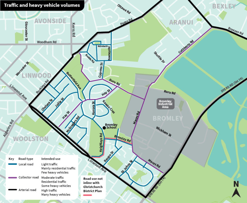
This map shows the main roads through the Bromley area, and the uses they were designed for (as designated in the Christchurch District Plan).
While most drivers use these roads as intended, some roads are carrying more traffic and heavier vehicles than they should be.
Data shows this is a particular problem for the route along Keighleys Road, from Linwood Avenue and into Bromley Road, to Maces Road.
Vehicle speeds
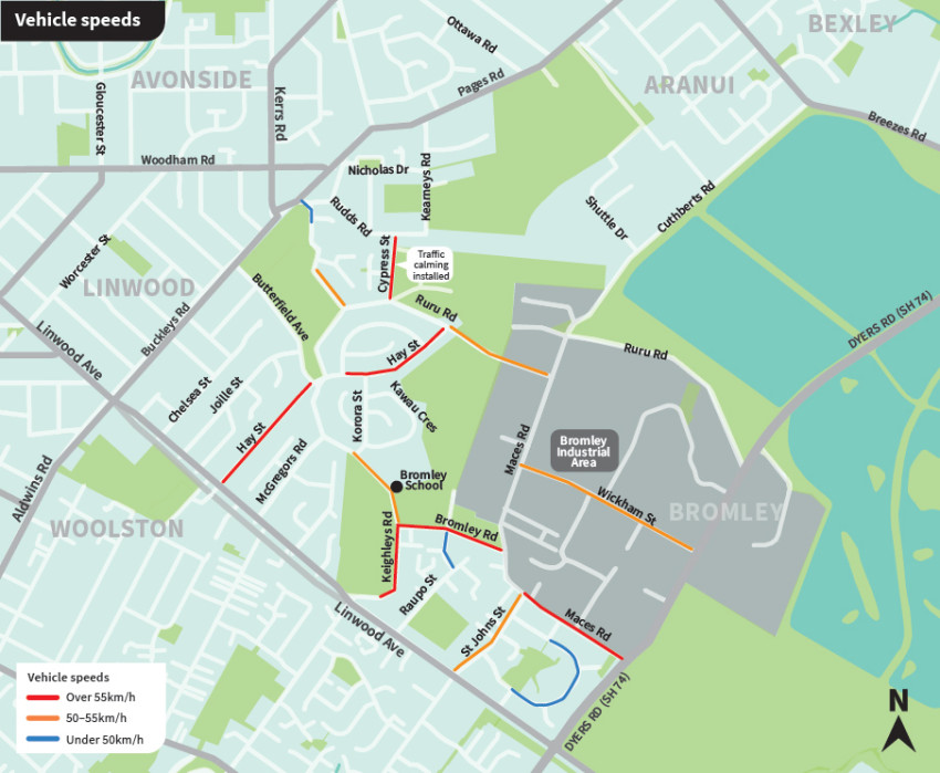
This map shows the speed data gathered on streets in the area.
This data supports the concerns of residents that speeds are too high, contributing to the fact that many feel unsafe using roads through the area.
Throughout Christchurch, we have used various traffic calming measures.
In Bromley, we plan to use a mix of speed humps, intersection narrowing, pedestrian refuge islands, and clearer road markings.
The first suite of Bromley works was approved by the Community Board on 9 December 2024 and completed in 2025.
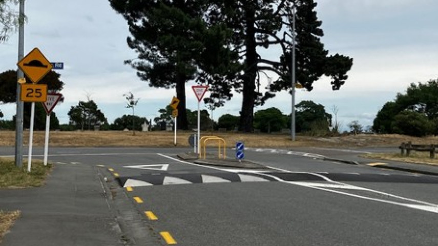
Traffic calming – Speed humps
Intersection narrowing
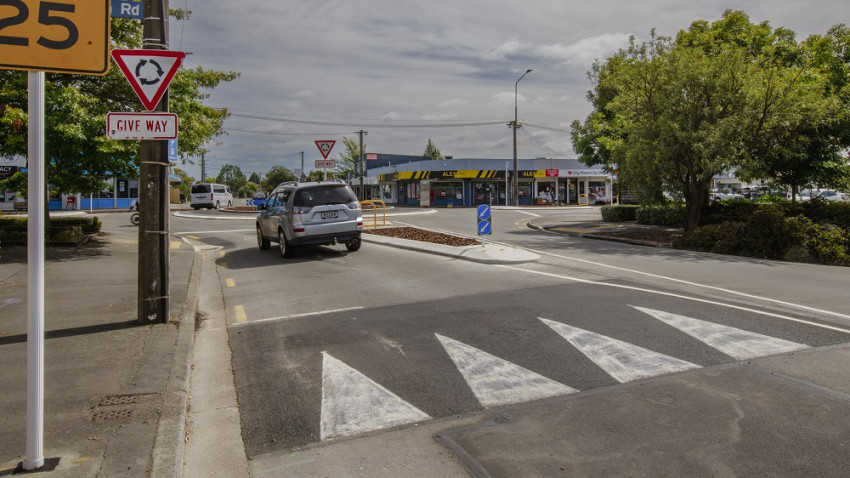
In some locations around Christchurch, we narrow intersections to make it safer for everyone to use. Sometimes, like in the photo below, this includes using pedestrian refuge islands and kerb buildouts.
We completed traffic calming work on Bromley and Keighleys roads in July 2025.
This work was identified as a priority in community feedback.
These measures aim to reduce traffic speeds, limit heavy vehicle use, and improve safety for cyclists and pedestrians, especially outside Bromley Primary School.
Future works
The Community Board will need to advocate for funding in the annual plan and long-term plan for this to progress, and we encourage Bromley residents and people who visit or travel through Bromley to get involved in any resulting community consultations.
If you think the works are important and want to see them completed, make sure you let your Community Board know(external link).
As funding becomes available, we will continue to work with the Community Board and residents to prioritise other works to improve safety for people living in or travelling through Bromley.
This table shows how the Bromley Streets Action Plan [PDF, 76 KB] might work.