How we propose to manage the increase in traffic when the Christchurch Northern Corridor opens. We're seeking your comment on recommendations for the St Albans, Edgeware and Mairehau areas.
Share this
Engagement on this project has now closed. Papanui-Innes and Linwood-Central-Heathcote Community Boards received all submitters feedback on Wednesday 8 May 2019.
Community Board meeting agenda(external link)
Feedback received [PDF, 1.2 MB]
Submission attachments [PDF, 1.4 MB]
Submission #23499 - presentation [PPTX, 3.2 MB]
Background
The Christchurch Northern Corridor (CNC) will help people to travel to and from the north of Christchurch. The CNC extends the Northern Motorway to connect QEII Drive and Cranford Street, through to Innes Road.
The Downstream Effects Management Plan that we are asking you to comment on covers the impacts on all streets in the St Albans, Edgeware and Mairehau area south of McFaddens Road. The recommendations of the Plan are covered on the following pages.
The Plan looks at ways to manage additional traffic and to mitigate the impacts of the additional traffic that will enter the local network at Cranford Street.
However, some of the methods of reducing the number of vehicles, such as encouraging ridesharing, the use of public transport and active transport, require work to happen outside of the area considered by the Plan. These methods are:
- upgrading the bus network
- providing express buses
- park and ride facilities
- further developing the existing cycle network
The Christchurch Northern Corridor and the Downstream Effects Management Plan are part of a wider package of transport projects to improve travel to and from northern Christchurch. Other projects include the Main North Road bus priority lanes (still to be constructed), Western Belfast bypass, Papanui Parallel cycleway and Northern Line cycleway (still be constructed) and the CNC shared path.
Feedback received from the community helped shape the Management Plan. We listened when you said you wanted safe access for schools, parks and shopping areas and safe areas for all people to walk and cycle.
The requirement for a Downstream Effects Management Plan came from an Environment Court ruling when the Christchurch Northern Corridor was approved. Council must complete the Plan before the opening of the Christchurch Northern Corridor and mitigate the effects additional traffic will have on the local network.
Full management plan [PDF, 14 MB]
Wednesday 20 March
10.30am – 12.30pm
Scottish Society Hall
136 Caledonian Road, St AlbansMonday 25 March
5pm – 7pm
St Albans School Hall
17 Sheppard Place, St AlbansTuesday 26 March
3.30pm – 5.30pm
Scottish Society Hall
136 Caledonian Road, St AlbansThursday 4 April
5pm – 7pm
St Albans School Hall
17 Sheppard Place, St Albans
We investigated the traffic impact on the area south of Innes Road. Even without the CNC there is anticipated to be increased traffic through the area due to population growth.
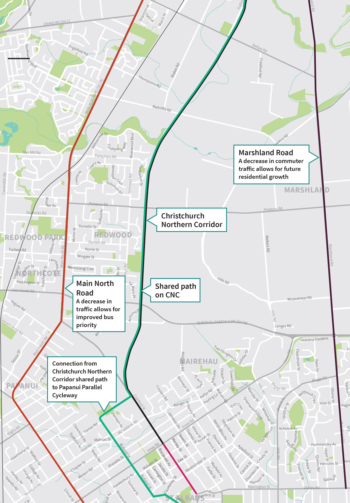
The map shows how the CNC will free up space on the local road network for all types of travel, taking some traffic from Main North Road and Marshland Road. Main North Road is the major bus route to and from the north of the city and reduced traffic will help bus movements. Reduced commuter traffic on Marshlands Road will make room for increased local traffic as the area is developed.
The shared path that runs alongside the CNC will connect to the Papanui Parallel cycleway to provide a continuous cycle route.
This draft Plan seeks to balance the needs of local communities with safety and accessibility considerations, while ensuring an accessible city for all Christchurch residents, businesses and visitors.
Major arterial upgrades
Using the existing road corridor, arterial road upgrades include:
- Upgrading of intersections
- Introducing clearways
- Investigating whether the clearway lanes should be High Occupancy Vehicle Lanes for vehicles carrying two or more people
Local road traffic calming
Options being considered:
- Raised intersections
- Narrowing sections of road
- Chicanes, bends and landscaping
- Mid-block raised platforms
- Turning restrictions
Introduction of speed zones
Nine safe speed community areas are proposed in St Albans to improve safety and discourage drivers selecting alternative short cut routes.
Safe access to school
The key issue in terms of safe access to schools is access across Cranford Street for children walking to and from St Albans School. Several improvements are being assessed.
Cycling
The introduction of peak period clearways on Cranford Street make this route during peak periods less safe for non-confident cyclists. It is anticipated that most cyclists will use the dedicated Papanui Parallel Cycleway and other quieter safer routes.
Access to parks
You have told us safe access to parks is important to you. A study is proposed to look at access and safety issues for St Albans Park and Malvern Park and develop options to make access safer.
Access to commercial areas
You have asked for safe access to your local (shopping and eating) commercial centres. The draft plan recommends transport studies are done for the four local activity centres impacted by the increased traffic. Corridor assessments along Edgeware Road and Westminster/Courtenay Streets are also required to look at enhancing access and amenity for pedestrians and cyclists.
Monitoring
Council will continue to monitor:
- Vehicle, pedestrian and cycle volumes
- Vehicle speeds
- Vehicle emissions
- Road noise and vibration
- Crashes
Additional projects might be required where monitoring indicates congestion or safety concerns.
Timeframes
Funding was allocated in the Long Term Plan 2018-2028 to complete projects identified in the Downstream Effects Management Plan.
The following pages break down the recommendations into three delivery stages:
Stage 1 - Projects proposed before the CNC opens in 2020
Stage 2 - Projects proposed within three years of the CNC opening
Stage 3 - Projects proposed to be delivered any time between the opening of the CNC and 2031
There will be opportunities for further public input on projects within these plans
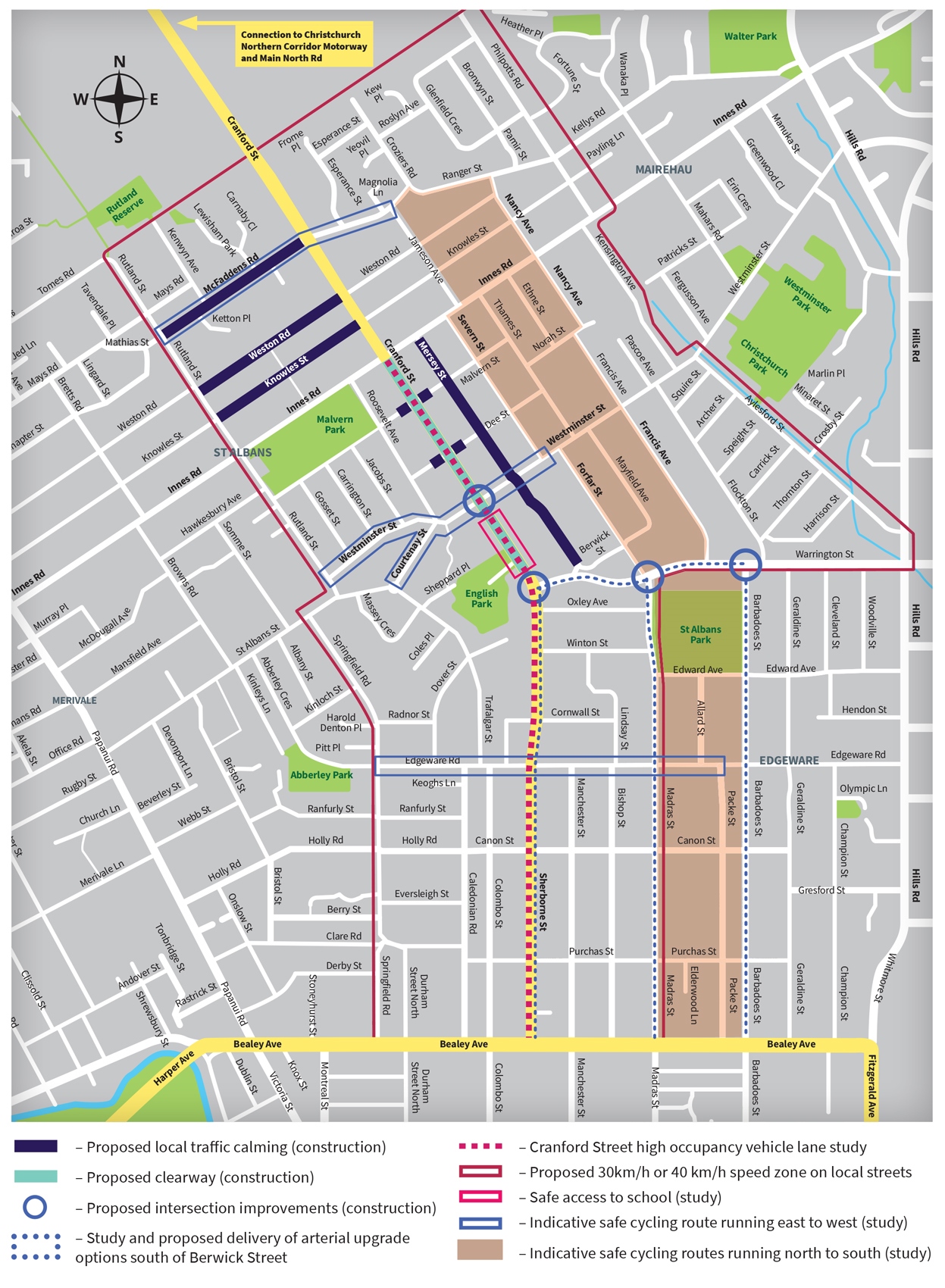
Stage 1 - projects proposed before the CNC opens
Proposed major road upgrades:
- Cranford Street clearways – peak period clearways along Cranford Street from Innes Road to Berwick Street.
- Westminster Street/Cranford Street intersection - upgrades to Westminster Street/Cranford Street intersection.
- Berwick Street/Warrington Street upgrades – upgrading of Berwick Street/Cranford Street signalised intersection and signalisation of the Forfar Street/Warrington Street and Barbadoes Street/Warrington Street intersections.
- South Berwick upgrades – downstream of Berwick Street arterial upgrade option that comes out of the scoping study.
- High Occupancy Vehicle (HOV) lane on Cranford-Sherborne Streets – investigate using the peak period clearways as HOV lanes (must have more than one person in the vehicle). This effectively extends the proposed CNC HOV lane south to Bealey Avenue and a northbound HOV lane up Sherborne and Cranford Streets.
Proposed introduction of speed zones
Introduce nine 30km/h (or 40km/h) reduced speed limit areas through the downstream local road network.
Proposed traffic calming measures
Proposed traffic calming on the following streets:
- Mersey Street (Innes Road to Berwick Street)
- Knowles Street (Cranford Street to Rutland Street)
- Weston Road (Cranford Street to Rutland Street)
- McFaddens Road (Cranford Street to Rutland Street)
- Malvern Street – left in and left out only at Cranford Street
- Dee Street – left in and left out only at Cranford Street
Proposed safe access to schools
Safe access across Cranford Street (study) – this study will look at a range of options including a new mid-block signalised crossing across Cranford Street near the English Park carpark entrance.
Proposed safe cycling routes
Cycle wayfinding signage
Development of and implementation of a wayfinding signage plan that directs cyclists at the northern end of Cranford Street (at McFaddens Road) and southern end of Cranford Street to safer cycling routes, such as Papanui Parallel Cycleway.
North-South cycle study
Undertake a study of an alternative north-south secondary cycle route through traffic calmed streets to the east of Cranford Street. This will enable safer north-south cycling without having to cross Cranford Street to access Papanui Parallel.
East-West cycle study
This will enable cyclists to more safely connect to the Papanui Parallel and the proposed north-south route.
- McFaddens Road secondary cycle corridor – undertake a route study of a cycling route both west (towards the Papanui Parallel) and east (towards the proposed north-south route) on McFaddens Road.
- Westminster Street/Courtenay Street secondary cycle corridor – undertake a route study of a cycling route both west and east of Cranford Street.
- Edgeware Road secondary cycle corridor – undertake a route study of a cycling route both west and east of Cranford Street.
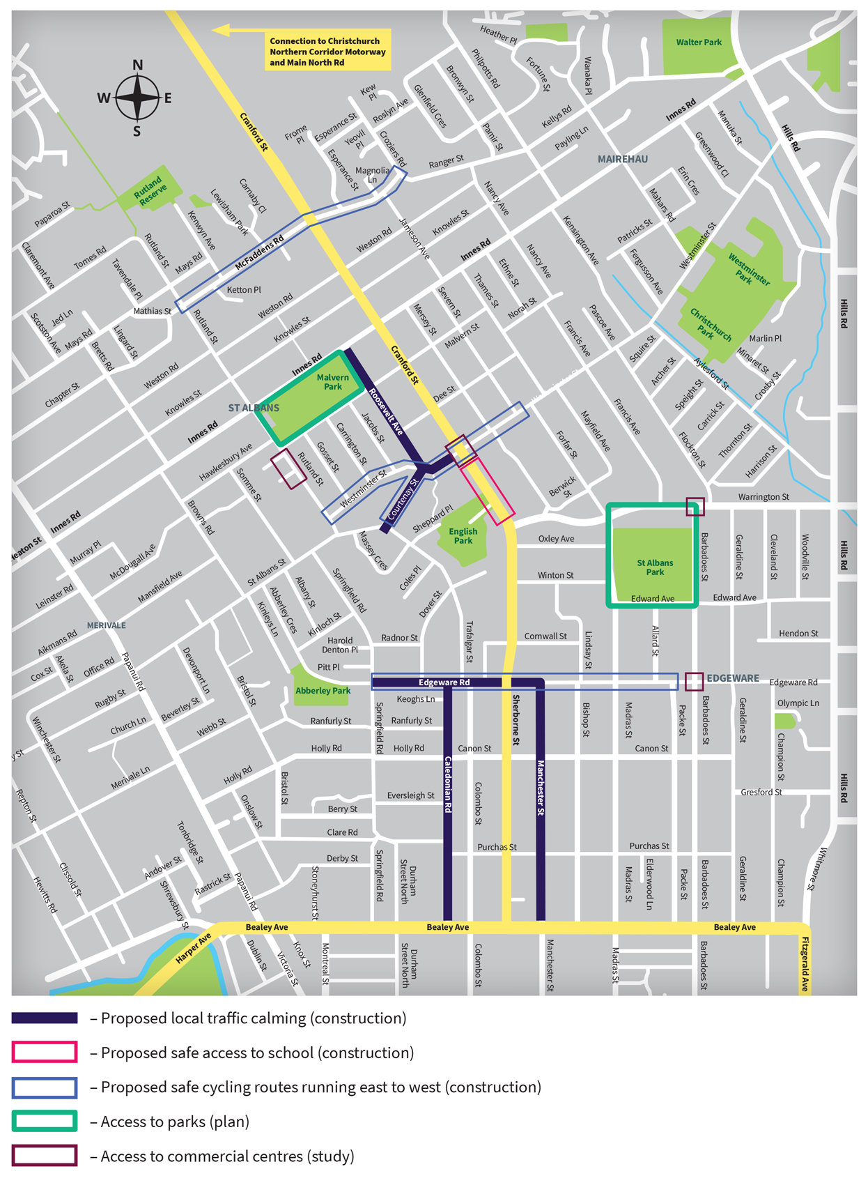
Stage 2 – projects proposed within three years of the CNC opening
Proposed traffic calming measures
Proposed traffic calming on the following streets where expected increases in traffic volumes are validated by the monitoring data:
- Roosevelt Street
- Caledonian Road
- Edgeware Road (Village)
- Manchester Street
- Westminster Street/Courtenay Street
Safe access to schools
Safe access across Cranford Street – implement any options identified in the study undertaken that have not happened through the intersection stage 1 upgrades.
Proposed safe cycling routes
McFaddens Road secondary cycle corridor – construct a secondary cycling route both west (towards Papanui Parallel) and east towards new south route on McFaddens Road.
Westminster Street/Courtenay Street secondary cycle corridor – construct a secondary cycling route both west and east of Cranford Street.
Edgeware Road secondary cycle corridor – construct a secondary cycling route both west and east of Cranford Street to connect to the Papanui Parallel and proposed north-south cycle routes.
Access to parks
St Albans Park – Develop a plan that will look at improving access to the park by pedestrians of different abilities, cyclists and motorists.
Malvern/Rugby Park – Develop a plan that will look at improving access to the park by pedestrians of different abilities, cyclists and motorists.
Access to commercial centres
A study that will consider safe access to activity centres by pedestrians, cyclists, and motorists:
- Westminster Street/Cranford Street Local Activity Centre Transport Study.
- Barbadoes Street/Warrington Street Local Activity Centre Transport Study.
- Barbadoes Street/Edgeware Road Local Activity Centre Transport Study.
- Rutland Street Local Activity Centre Transport Study.
A study which will focus on safe access by pedestrians along the route and crossing the route especially for vulnerable road users:
- Westminster Street-Courtenay Street Corridor Study (Rutland Street to Forfar Street)
- Edgeware Road Corridor Study (Springfield Road to Barbadoes Street).
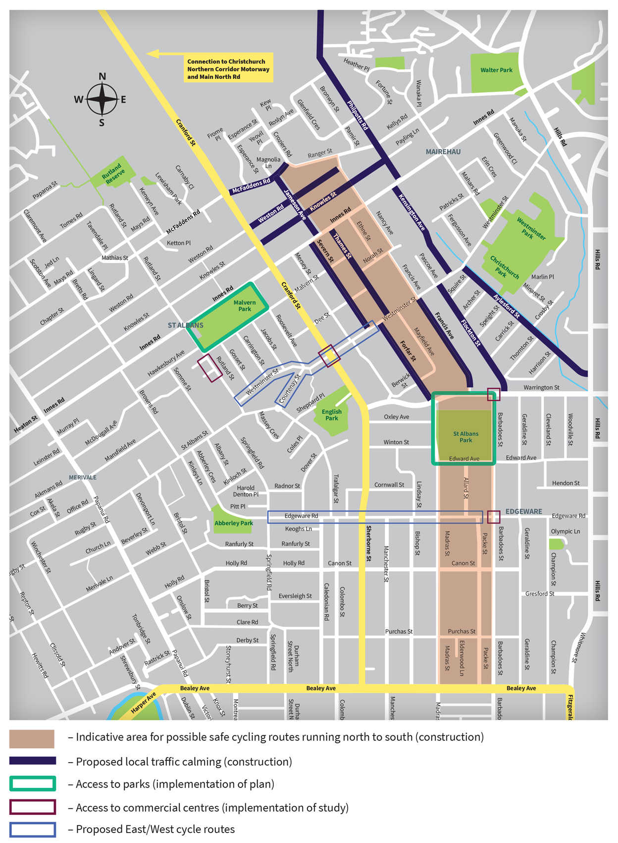
Stage 3 – projects proposed after the opening of the CNC and up to 2031
Proposed traffic calming measures
Introduce additional traffic calming measures only where monitoring indicates high levels of short cutting are occurring. Possible routes include:
- McFaddens Road (Cranford Street to Ranger Street)
- Knowles Street (Cranford Street to Philpotts Road)
- Weston Road (Cranford Street to Nancy Avenue)
- Jameson Avenue
- Forfar Street (Warrington Street to Westminster Street)
- Flockton Street
- Severn Street
- Thames Street
- Aylesford Street
- Kensington Avenue
- Philpotts Road
- Francis Avenue
Safe cycling routes
North-South secondary cycle corridor – construct an alternative north-south cycle route through traffic calmed streets to the east of Cranford Street. This is likely to involve road marking, signage and new crossing facilities.
Access to parks
St Albans Park Access Plan – Implementation of the access plan as required to address access issues.
Malvern/Rugby Park – Implementation of the access plan as required to address access issues.
Access to commercial centres
Implement the following study recommendations:
- Westminster Street/Cranford Street Local Activity Centre Transport Study.
- Barbadoes Street/Warrington Street Local Activity Centre Transport Study.
- Barbadoes Street/Edgeware Road Local Activity Centre Transport Study.
- Rutland Street Local Activity Centre Transport Study.
- Westminster Street-Courtenay Street Corridor Study (Rutland Street to Forfar Street).
- Edgeware Road Corridor Study (Springfield Road to Barbadoes Street.


