Population growth, housing issues – including housing affordability – and climate change are prompting a re-think of some of Ōtautahi Christchurch’s planning rules.
Share this
Consultation has now closed
Consultation on Plan Change 14 has now closed. People were able to provide feedback from 17 March to 12 May 2023.
Please refer to the PC14 District Plan page(external link) for the latest updates.
We’re proposing changes to our District Plan to provide for our continued growth and prosperity.
- Housing and Business Choice Plan Change (PC14)(external link) – to bring our District Plan in line with government direction that has been given via the National Policy Statement-Urban Development (NPS-UD) and the Resource Management (Enabling Housing Supply and Other Matters) Amendment Act (The Act) to enable more development in the city’s existing urban footprint.
- Heritage Plan Change (PC13)(external link) – Eleven new residential heritage areas across the city are identified for protection in the District Plan to recognise Ōtautahi Christchurch’s special identity and we’re adding around 60 buildings, items and building interiors to the Schedule of Significant Historic Heritage.
Early public feedback on draft changes in April last year helped us shape the notified plan changes outlined. We welcome your submissions on these proposed plan changes. This will help us implement the changes needed to bring our District Plan in line with government direction.
To find out what this means for your property, use our interactive map(external link).
You can download the full consultation document [PDF, 4.1 MB] or read the information below before making a submission at the bottom of this page.
Our growth challenge
Our population is growing. Over the next 30 years, it’s predicted we’ll need more than 40,000 new houses in Ōtautahi Christchurch to ensure everyone has a place to live.
This means re-thinking some of our planning rules to allow more housing choice and provide greater opportunities for business development.
We need to provide for the growth of housing and commercial centres in the best locations, to help address issues such as climate change and housing affordability. This means more houses close to our growing commercial centres, where there’s good access to services, public transport networks and infrastructure. Living within easy reach of work, school and shops makes getting around easier and helps reduce transport emissions.
However, we also need to ensure development remains restricted in areas where there’s good reason, or limited where we need to protect and maintain areas of value.
Our proposed Housing and Business Choice Plan Change (PC14)
Changes in our Housing and Business Choice Plan Change, which was publicly notified on 17 March 2023, are directed by government legislation.
There are new national standards for multi-housing developments called the Medium-Density Residential Standards (MDRS). The MDRS enables housing choice across Aotearoa New Zealand’s main urban areas. These standards support the development of three homes up to three storeys on each site, without the need for resource consent.
The National Policy Statement on Urban Development 2020 (NPS-UD) requires even greater building development than the MDRS – both residential and commercial – to be allowed within and around the central city, suburban commercial centres and planned high-frequency and high-capacity public transport. This is to enable more people to live near existing services, public transport networks and infrastructure. What we can influence is how much and where additional development should be enabled.
This proposed plan change creates a range of residential and commercial zones in Ōtautahi Christchurch, which enable more development to happen at different heights, with the highest development enabled in the central city and suburban commercial centres.
The MDRS would’ve come into effect for most of Ōtautahi Christchurch from PC14’s notification date of 17 March 2023. However, it won’t come into effect until a final decision is made on the plan change in about March/April 2024. That’s because we’ve proposed a city-wide restriction, called a Qualifying Matter, to protect sunlight access for homes, which they would not get under the MDRS. Until the ‘Sunlight Access’ qualifying matter is decided on, as well as others we’re proposing, the MDRS can’t take effect.
What’s a Qualifying Matter? Qualifying Matters are characteristics or qualities specific to some areas or properties, which means the rules enabling increased development will be modified to the extent necessary to maintain and protect values or manage effects. They are prescribed and defined under the Resource Management Act.
Additionally, we’re proposing a mechanism to help maintain the city’s tree canopy cover on land that is subdivided. Financial contributions could be required from those developing land that do not keep existing trees or plant 20 per cent tree canopy cover on a site, and 15 per cent tree canopy over any new road. We also propose identifying protected trees listed in the current District Plan as a Qualifying Matter.
To speed up the opportunity to develop more housing, a new planning process, called the Intensification Streamlined Planning Process (ISPP), has been introduced by the Government. The public can submit on the proposed intensification rules, but following hearings, no appeals will be allowed. However, Judicial Review to the High Court remains possible.
Under the process, the Housing and Business Choice Plan Change and Heritage Plan Change must be completed within a fixed timeframe. While the Minister for the Environment has yet to formally confirm a new date after the delay of notification, we expect this will be in March/April 2024. We need to accept: We can influence: You can find out what the proposed changes mean for you and your property by using our interactive map(external link). Enter your address to find out what your proposed zone is, what development will be allowed, and in what circumstances a resource consent may be required. On 8 September 2022, the Council voted not to notify a previous version of Plan Change 14. Since then, this alternative proposal has been drafted and following approval from the Council on 1 March 2023, publicly notified. The table below is a summary of changes and additions made to the 2022 version of the plan change. Topic Summary of changes made New and modified Qualifying Matters New and modified residential controls New and modified commercial controls New and modified school and hospital controls Zoning changes The proposed plan change identifies residential and commercial zones where greater levels of development is enabled (densities and heights). In some zones, this will still be subject to resource consent where several matters must be considered, mostly in regard to site layout and building design. We propose concentrating this zone around our larger commercial centres, including the central city. We’re required to enable at least six storeys surrounding the walkable catchment of these centres, so we propose enabling heights of 20 metres within at least 1.2 kilometres of the central city and smaller walking catchments for other centres. In the central city, this would enable the construction of apartment buildings and multi-storey flats, with sites closest to the central city enabled to 32 metres, or about 10 storeys. Any high-density area further away from the central city would be limited to 20 metres. Housing that could be constructed without a resource consent will: Indicative illustration only: High-Density Residential Zone Housing that does not meet one or more of these standards will need resource consent and may need written approval from neighbouring properties but will not be publicly notified (for developments of three or fewer units). Resource consent is required when four or more housing units are constructed. However, no written approvals or notification is needed for the construction of four or more units when complying with the height and other standards above. Housing of between 14 and 20 metres will be managed via resource consent, as follows: The increased height limit of 32 metres is proposed to be limited to only those areas immediately surrounding the central city. Other areas are proposed to be limited to 20 metres. This zone is the baseline for increasing housing in our city. Rules for this zone are legally required by the Enabling Housing Act and must be applied to most residential areas of Ōtautahi Christchurch. This Act introduced the Medium-Density Residential Standards that will allow development of up to three homes of up to 12 metres on a single property, without resource consent – if they comply with the specified standards. While the MDRS will apply across all urban residential areas, we’re proposing to limit the extent of where such development would apply through Qualifying Matters. See section on qualifying matters for further information. Buildings that could be constructed without a resource consent may: Proposed buildings that do not follow all these requirements will need a resource consent, which may need neighbours’ approval, but will not need to be publicly notified (for developments of three or fewer units). Resource consent is needed when four or more units are constructed. However, no written approval from neighbouring properties or notification is needed for the construction of four or more units, when complying with the above rules. The MDRS for this zone are legally required by government legislation. The Council can make MDRS more lenient or restrict standards further by identifying Qualifying Matters. Additional controls may also be added where they do not compromise the MDRS. Indicative illustration only: Medium-Density Residential Standards (MDRS). We’re proposing that some areas of the city within the Medium-Density Residential Zone include precinct overlays. Precincts may enable more or higher housing or may have a different minimum lot size in areas such as the Port Hills areas of Cashmere and lower Huntsbury (where the MDRS apply). The NPS-UD enables even greater building development than what is allowed under the MDRS within and around the central city and suburban commercial centres. It is important to note that while greater development is enabled, resource consent will still most likely be needed. There is a hierarchy of commercial centres, based on the direction set in the NPS-UD and national planning standards, and we’re proposing different zones in and around these centres. The highest development – both residential and commercial – will be enabled in and around our biggest commercial centres, with this gradually reducing out to our smaller ‘Neighbourhood Centres’. The proposed height of development enabled is based on access to services, public transport, walking and cycling networks, and infrastructure available in these commercial centres. It is important to note that the commercial centre boundaries are not changing, but the height of what can be built within and surrounding them is increasing. Indicative illustration only: Edge of Local Centre. The table below shows the different centres and building heights that we propose enabling within and around our commercial centres. Centre type Building height Neighbourhood Centre and Small Local Centres Small isolated commercial areas, like local dairies Increased to 12 metres, in line with Medium-Density Residential Zone Medium Local Centres Bishopdale, Prestons*, Barrington, Belfast/Northwood** Increased to 14 metres (four storeys, depending on building design), in line with being a precinct within the Medium-Density Residential Zone Large Local Centres Sydenham, Merivale, Church Corner Increase to 20 metres (six storeys, depending on building design), in line with High-Density Residential Zone Town Centres Linwood, Belfast/Northwood**, North Halswell, Shirley/Palms* Increase to 20 metres (six storeys, depending on building design), in line with the High-Density Residential Zone Large Town Centres Riccarton, Hornby, Papanui Increase to 22 metres for commercial developments (six storeys, depending on building design) and 20 metres in the surrounding High-Density Residential Zone City Centre (This area is currently the Commercial Central City Business Zone in the District Plan) 90 metres, except for: • Victoria Street commercial area – 45 metres • Sites around Whiti-reia Cathedral Square - 45 metres * For areas outside of the vacuum sewer wastewater system constraints only. See section on infrastructure for more. ** The Belfast Commercial Centre has been proposed as a Town Centre (enabling 20-metre commercial buildings) with the surrounds enabling 14-metre residential buildings. Subdivision thresholds within commercial centres are not changing from what the current District Plan anticipates (250 metres2 for suburban commercial centres and no minimum lot size for the central city). Subdivision thresholds around commercial centres will vary in accordance with the relevant residential, industrial, or mixed-use zone provisions. All subdivision applications (regardless of zone or allotment size) will trigger the need for resource consent. Our city centre is where we want the most and highest development to occur, such as high-rise offices and residential apartment blocks. The NPS-UD requires us to maximise development opportunities within the City Centre Zone. This includes everything currently zoned as Commercial Central City Business, which is loosely bordered by Madras, Tuam, Montreal and Kilmore streets, and either side of Victoria Street to Bealey Avenue. Resource consent will still be needed to ensure that development is of a high quality but building heights up to 90 metres are anticipated. Lower height limits will apply around Whiti-reia Cathedral Square and Victoria Street to manage shading and building dominance on important public spaces and adjoining lower-rise residential neighbourhoods. Qualifying Matters apply to areas like New Regent Street and the Arts Centre where limiting heights will protect heritage values. There is no proposed change from the current District Plan so we’re continuing to provide no minimum site size for subdivision in the Central City Zone. We propose adjusting building heights within the City Centre Zone. However, a resource consent will be needed for most developments within the central city to enable us to assess the effects of shading, wind, and urban design requirements. Some rules are changing to ensure that development in the City Centre is of a quality expected for our pre-eminent commercial centre. Our adjusted height limit in the City Centre Zone is 90 metres except for: We’re adjusting the requirements for new developments in some of the Central City Mixed-Use Zone and the Commercial Mixed-Use Zone. These are within the walkable catchments of commercial centres that the NPS-UD directs us to intensify further, to create a city with its highest buildings at its centre, gradually decreasing in height out to the suburbs. The proposed amendments include: The minimum lot size for subdivision in the Mixed-Use Zone will remain at 250 metres squared, while the Central City Mixed-Use zones will stay at 500 metres squared. Within the Central City Commercial Mixed-Use Zone, permitted building heights will increase from 17 to 32 metres, to match the surrounding High-Density Zone. This will exclude the Southern CCMU Precinct, where 21 metres will be enabled. The building heights permitted in the Commercial Mixed-Use Zone will increase to 20 metres, to match surrounding areas. Rules to manage the effects of new buildings will be similar to the city centre. Proposed housing in the Central City Mixed-Use Zone and Commercial Mixed-Use zones will need to meet the residential development standards as set for the High-Density Residential Zone.
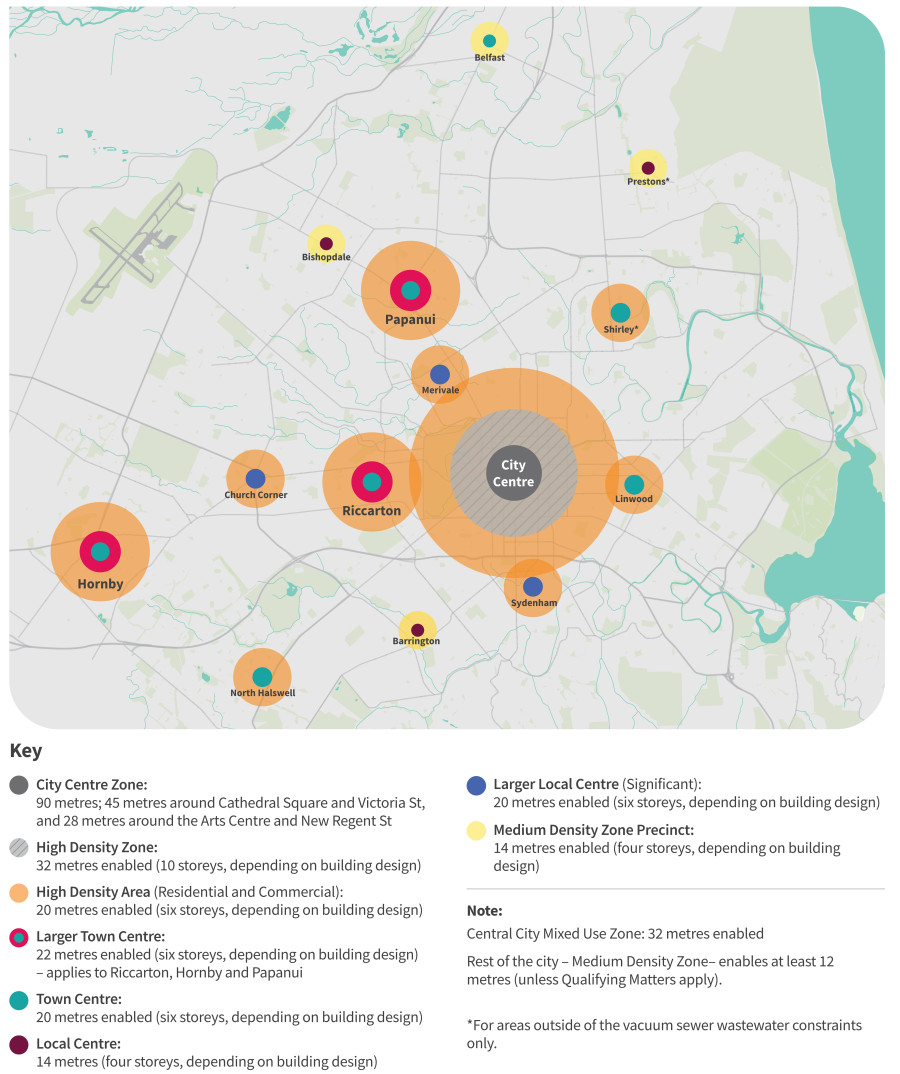
Subdividing
Building height and occupation
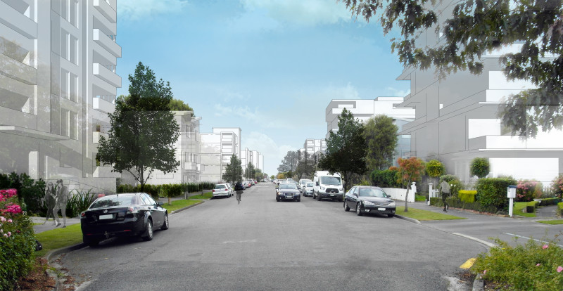
Subdividing
Building height and occupation of land
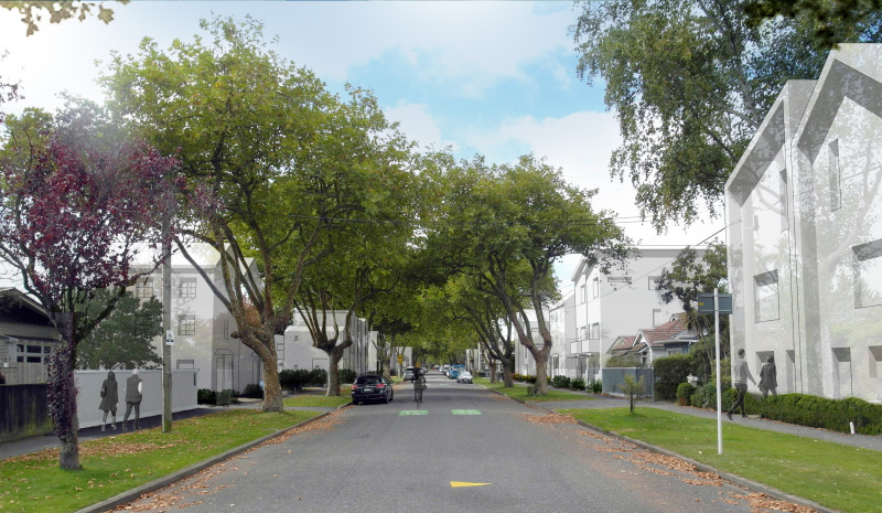
Precincts within the Medium-Density Residential Zone
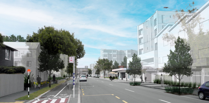
Heights within and around commercial centres
Subdividing
City Centre Zone
Subdividing
Building heights and development
Central City Mixed-Use, Commercial Mixed-Use and Industrial zones
Subdividing
Building heights and development
Areas limited by Qualifying Matters
Not all parts of our city are suitable for the level of increased development enabled by the Act. Some areas have qualities, known as Qualifying Matters, which mean rules enabling increased development will be modified to maintain and protect those qualities or manage their effects. This may include retaining a lower level of residential density and building heights, and/or managing development through specified matters and resource consent conditions.
Meeting the threshold
Strong evidence is required to apply a Qualifying Matter to reduce the level of development that may be otherwise provided for under MDRS or the NPS-UD. A qualifying matter does not provide blanket protection from housing intensification, as even a low-density residential zone provides for some level of housing intensification.
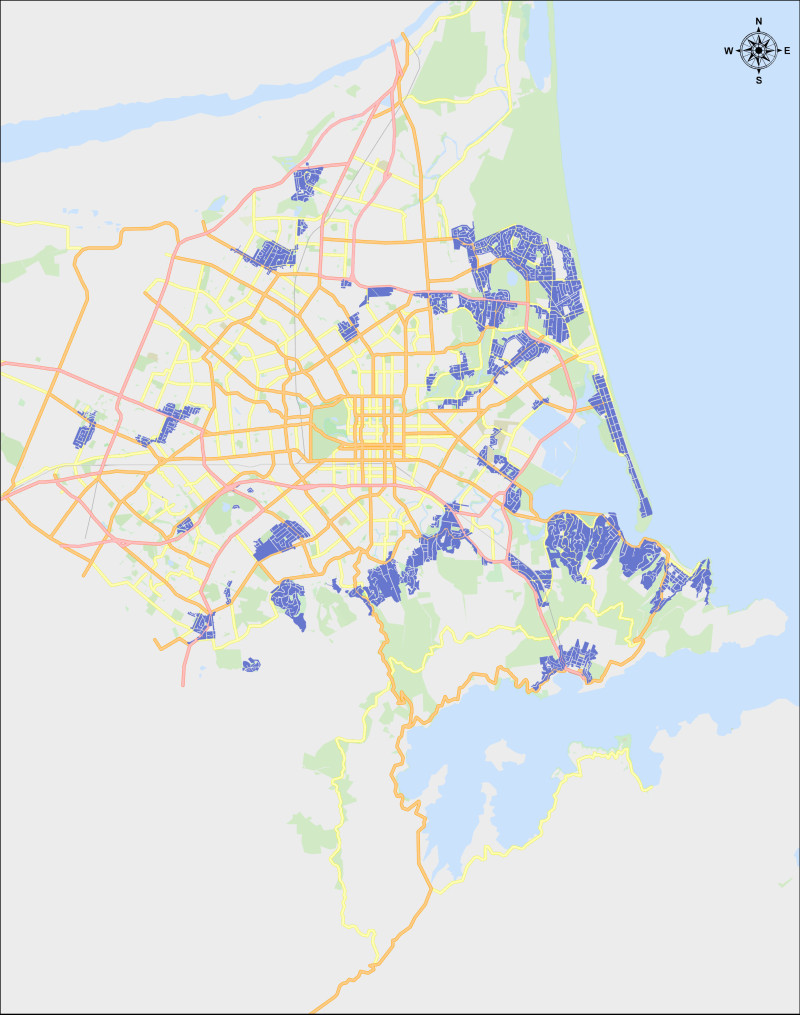
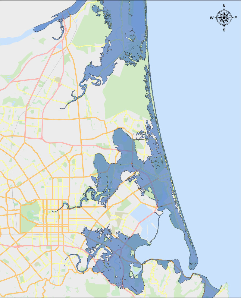
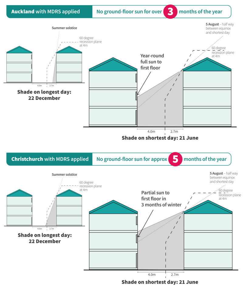
We propose that most of the District Plan’s current limitations on greater densities are kept, including those that manage outstanding landscapes, sites of ecological and cultural significance, heritage, significant utility and infrastructure overlays, and areas at risk from natural hazards. Our proposed Qualifying Matters are: *These are proposed as part of the Heritage Plan Change (PC13). Our drinking water, stormwater, wastewater and public transport systems will need to support our increased population and housing based on growth projections for the next 50 years. In some parts of the city our major pipes can’t accommodate increased growth. Public Transport Accessibility Restriction We’re proposing to limit the extent of where the MDRS would be enabled to near the highest-frequency bus routes and routes that connect larger commercial centres. Broadly, this means that outer suburbs, such as Parklands, south Halswell, Casebrook, Lyttelton and most of the Port Hills, would be unable to progress with medium-density development – see below for an overview map. This Qualifying Matter focuses intensification within and around commercial centres. This is to promote the use of public transport and reduce dependency on the use of private vehicles. The Qualifying Matter would not restrict any current Residential Medium-Density Areas or proposed High-Density Areas. Map of areas where the MDRS would be restricted due to the Public Transport Accessibility Qualifying Matter. Vacuum Sewer Wastewater Constraint Areas We propose limiting development in Shirley, Aranui and Prestons due to wastewater system constraints. Vacuum-sewer wastewater systems were installed post-earthquake to cope better with liquefaction and land settlement. The system was designed for the housing intensification allowed at that time. Since then, the District Plan has allowed more intensification in the Shirley area than the vacuum-sewer system was designed for. The vacuum-sewer pipes in Shirley and Aranui have reached capacity and Prestons is also constrained. This Qualifying Matter means most of the Shirley, Aranui, and Prestons area, can only be developed like-for-like. Potential developers should talk with us first to see what can be accommodated. High-risk natural hazards proposed as Qualifying Matters include coastal inundation, coastal erosion, and tsunami hazard. Coastal inundation and erosion hazards have been developed as part of Plan Change 12, set to be notified later in 2023. Coastal hazards specific to urban zones have been included as part of this plan change to better control intensification. Any residential development within these hazard areas needs resource consent, with strong controls to avoid any subdivision. The latest tsunami hazard information from NIWA has also been included as a qualifying matter, reflecting expected sea-level rise over the next 100 years. Development within tsunami hazard areas is proposed to be restricted to only a suburban density of one two-storey dwelling per site. Full extent of 1:500 year tsunami hazard with 1.06-metre sea-level rise applied. We’re proposing 11 new Residential Heritage Areas (RHAs). These neighbourhood areas have buildings and features that are collectively (rather than individually) significant to the city’s heritage and identity, that we want to retain for their coherent history. Our proposal also introduces a buffer for Residential Heritage Areas that have a high-density border, to better protect their edges. We also propose adding 44 heritage buildings or items and 26 building interiors to be protected under the District Plan. As with existing scheduled buildings and items, these will require a resource consent for significant changes such as building alterations, relocation, or demolition. Both Residential Heritage Areas and additional buildings and items being added to the schedule for protection are proposed Qualifying Matters. For more information see Heritage Plan Change (PC13)(external link). Residential Character Areas are identified in the District Plan by Character Area Overlay - residential neighbourhoods that are distinctive from their wider surroundings that we want to retain for their coherent character. Proposed as Qualifying Matters, there are currently 15 Character Areas in Christchurch City. They were last reviewed in 2015 on the basis that at least 80 per cent of the properties in the area contributed to the character values that made it special. We propose removing two of the character area overlays in Sumner (Clifton and Esplanade Character Areas), as they no longer meet the criteria. We also propose that seven reduce in size, six remain the same, and Lyttelton’s Character Area increases in size. Following early feedback on our draft Housing and Business Choice Plan Change in April 2022, three new Character Areas are proposed in: Currently, changes to a property within a suburban Character Area usually need a resource consent to assess alterations that may affect the character of the property or the wider character area. We must grant the consent, but it can be subject to design conditions via a controlled activity consent. In recognition of the status of a Qualifying Matter, we propose introducing a resource consent requirement as a restricted discretionary activity, to help us better protect Character Areas. While some infill development will be allowed, we will have more ability to decline a resource consent where the design of a new house, or changes to an existing house, aren’t in keeping with the Character Area. Subdivision will also be more restrictive, depending on the zone and area. For example, within a certain Character Area an additional house may be allowed on an existing site, or to the rear on a new site, but it may be limited to between five and eight metres (one or two storeys, depending on building design). It may require a larger garden and existing trees to be retained, with the house or houses set further back from the street and other boundaries than would be allowed for in a general suburban area. Rules for the Character Areas will differ depending on the character values of each area, as well as the District Plan zone in which the character area is located. The character values that are already being used to assess any development designs submitted to us are proposed to remain the same. We know trees are important to our residents. They help tackle climate change, reinforce our identity as the Garden City, provide shade and a range of other environmental, economic, cultural and social benefits. We’re working on ways – both through this plan change and in other non-regulatory ways – to ensure that green spaces and tree canopy can be retained as much as possible, while enabling more housing choice for our residents. As part of this plan change, we propose Financial Contributions be required where trees are not retained or planted – to help fund increasing our tree canopy cover in the city (see the section on Financial Contributions). Additionally, we propose that the Schedule of Significant and Other Trees, currently included in the District Plan, becomes a Qualifying Matter. We’ve reviewed the existing trees on the list to provide the necessary evidence required under the NPS-UD to be considered as a Qualifying Matter. A further review of the Schedule of Significant Trees to protect additional trees could be completed as part of any subsequent plan changes. As part of this plan change, we’re proposing to update tree setbacks to better protect individual trees and, in some zones, to incentivize more tree planting than is currently required. Our Tree Policy outlines how we manage and maintain trees in public open spaces. The Urban Forest Plan(external link) provides a long-term vision and strategy to maximise the health and sustainability of the city’s urban trees and forests. It was open for feedback in February 2023 and closed on 6 March 2023. We’re proposing a city-wide Qualifying Matter across all areas where the MDRS would otherwise apply. This Qualifying Matter relates to recession planes – the vertical angle typically applied at the boundary of a site to ensure buildings provide for sunlight access on neighbouring properties. Recession plane angles are typically designed to take into account the sun approach angle relative to the local environment (such as a site’s latitude or topography). However, the MDRS applies a recession plane at the same angle across all Tier 1 councils (Auckland to Selwyn), regardless of latitude or a site’s orientation to the sun. The Sunlight Access Qualifying Matter proposes to modify this approach to better reflect Christchurch’ specific latitude and climate. It ensures a more equitable outcome across Tier 1 councils, providing for sunlight access at all levels of a building, increasing sun exposure, whilst better protecting and enhancing property values. A comparison of the MDRS and what we propose is provided in the table below. MDRS Sunlight Access Qualifying Matter Height At 4 metres above ground level At three metres above ground level Northern boundary angle 60° 60° Southern boundary angle 60° 50° East-west boundary angle 60° 55° In addition to the above, buildings greater than 12 metres in height must be set back seven metres from east-west boundaries, six metres from northern boundaries, and eight metres from southern boundaries, are exempt from recession planes (subject to zone controls). Under the Act, the MDRS rules have immediate legal effect upon notification, unless a Qualifying Matter applies. Since the Sunlight Access Qualifying Matter would apply to all areas where the MDRS would otherwise be enabled, this means there is no immediate legal effect of the MDRS rules. Instead, the existing District Plan rules will apply, requiring a resource consent. This applies in the period between when PC14 is publicly notified (17 March 2023) and when the Council makes a determination on the Independent Hearings Panel’s final recommendation on the Plan Change (anticipated in March/April 2024). The sun’s angle in Christchurch is different to its angle in Auckland, and the colder climate here means each hour of sunlight has greater benefit. The Sunlight Access Qualifying Matter aims to give Christchurch developments under the MDRS the same amount of sunlight access as Auckland developments. Changes to the Resource Management Act mean we’re now able to ask for Financial Contributions from anyone looking to develop land, even when a resource consent isn’t needed (as per the new direction of the Enabling Housing Act). Financial Contributions differ from Development Contributions, and are charged through the resource consenting process to ensure anyone developing land pays a fair share of the cost of development. Development Contributions are narrower in scope and are used to recover the costs for new assets or to increase the capacity of infrastructure. Financial Contributions can be collected to manage the direct impacts of a particular development. Councils can charge anyone developing land both Financial Contributions and Development Contributions but cannot recover more than the financial impact of the development. We’re proposing that anyone wishing to develop land may need to pay Financial Contributions to help mitigate some of the negative effects caused to our city’s tree canopy. To avoid paying Financial Contributions those developing land must either plant at least 20 per cent tree-canopy cover on a site or retain existing trees. Any development creating new roads will need to ensure that at least 15 per cent of the road reserve has tree canopy. Financial Contributions will be used by us to plant trees on Council-owned land.
Find out what this means for your property
Check out our interactive maps(external link) to find out what the proposed changes mean for your property. You can enter an address to find out what zone the property is in, and what development is allowed in that zone.
Next steps for our plan changes
The public now has an opportunity to make a submission on the proposed intensification and heritage rules in our plan changes, noting that Christchurch City Council must implement MDRS and greater intensification. Following public consultation there will be hearings when submitters can speak to an Independent Hearings Panel – expected to take place in late 2023.
Proposed controls relating to intensification won’t come into effect until the final recommendation from the Hearings Panel are agreed to by the Council or determined by the Minister for the Environment. This aspect needs to be completed within a fixed timeframe, anticipated to be March/April 2024. All heritage-related controls have immediate legal effect upon notification of the plan change on 17 March 2023.
Decision-making process
17 March to 12 May 2023 – notification period for public submissions
Around June–July 2023 – submissions on the notified plan changes are published and further submissions on plan changes opened
Around October–November 2023 – Independent Hearings Panel conduct hearings (The Council can choose to conduct optional pre-hearing mediation)
Hearings Panel provides the Council with recommendations
Please note:
- If the Council rejects any of the Hearings Panel’s recommendations, the Minister for the Environment will decide on the rejected provision or the Council’s alternative recommendation.
- There is no opportunity to appeal any decisions. There remains a right of Judicial Review to the High Court.
- The final date of when plan change must be completed is subject to the Minster for the Environment's approval.
Friend of submitters
If you have trouble making a submission, we have a Friend of Submitters service available to help. To access this fully independent service, please email Jane West - CHCHPC13-14@jwest.co.nz or call (03) 324-3324.
