Have your say on the proposed changes and let's work together to create a safer neighbourhood for everyone.
Project status: Decision
Open for feedback: 8 April 2022 to 3 May 2022
Share this
Consultation is now closed
Consultation on the Opawa neighbourhood safety improvements has now closed. People were able to provide feedback from 8 April to 3 May 2022. During this time we heard from 139 individuals and groups. The table of consultation feedback [PDF, 18 MB] is now available.
An updated plan was taken to the Waikura Linwood-Central-Heathcote and Waihoro Spreydon-Cashmere Community Boards on 15 June 2022. These Community Boards recommend that Council approve the plans with further 30km/h speed limits on the following streets:
- Beckford Road (from Fifield Terrace to Hawford Road)
- Hawford Road (from Beckford Road to Opawa Road)
- Garlands Road (from Aynsley Terrace to Opawa Road)
- Earl Street
- An additional section of Opawa Road
Council approved this plan without any further changes on Thursday 7 July. You can view the meeting minutes, which include the formal resolutions, online at christchurch.infocouncil.biz.(external link) You can also view the recording of the decision being made here(external link).
Opawa area updated speed plan Supporting treatments for speed change update
Way safer for everyone
We’ve heard community concerns about vehicles travelling at excessive speed through Opawa streets and there have also been a number of minor crashes in the area over the past few years.
To address these concerns we’re proposing to reduce the speed limit from 50 km/h to 40km/h and 30 km/h on selected streets in the Opawa/Beckenham, add a cycle lane on Opawa Road, as well as upgrade the crossing on the corner of Opawa Road and Vincent Place.
This change will make your neighbourhood safer, no matter whether you walk, scoot, cycle or drive.
Safe Speeds
This proposed speed reduction is part of the Slow Speeds Neighbourhood programme focused on identifying areas in Christchurch where the community has expressed support for slower speeds. This is part of the central government Road to Zero programme(external link).
Lowering the speed limit is one of the ways we can create safer streets for all users, create a sense of place within a neighbourhood and encourage other modes of active transport.
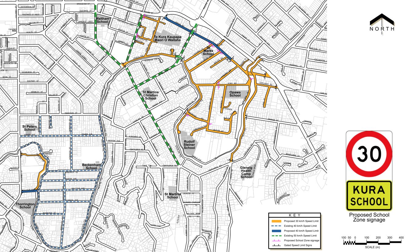
We’re proposing to reduce the speed from 50 km/h to 40km/h and 30km/h on the road network pictured on the map below.
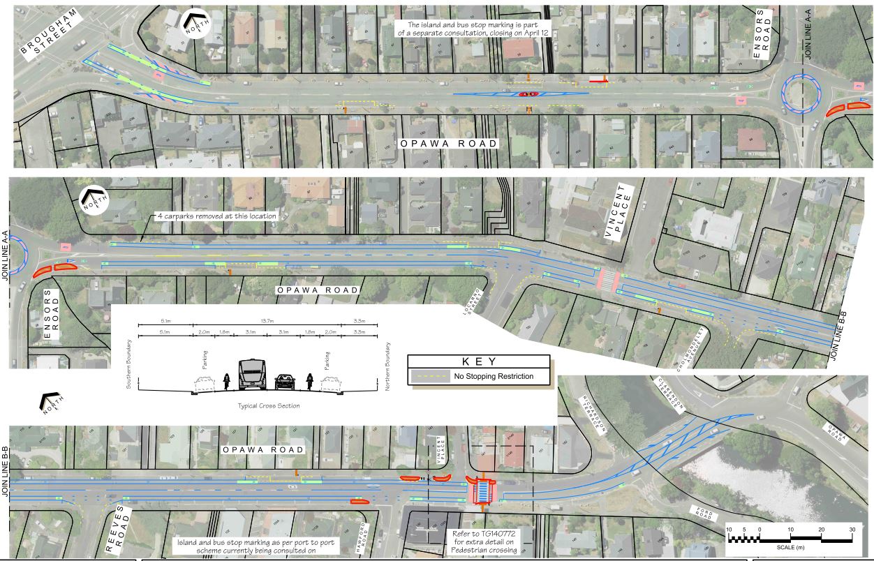
Supporting treatment
- Additional coloured surfacing when entering Opawa Road from Brougham Street, to support the change in speed limit.
- The pedestrian island (being consulted on for the Port to Port bus stop improvements(external link)) will add a mid-block traffic calming feature.
- A build-out on the southeast corner of the Opawa Road/Ensors Road roundabout to reduce crossing distances for people walking, particularly when transferring between bus routes.
- Cycle lane marking on Opawa Road from Ensors Road to the Opawa Road shops to narrow the traffic lanes and support the speed change from 50km/h to 40km/h. To accommodate safe cycling, four parking spaces (outside 32 Ensors Road) will need to be removed.
- Red coloured surfacing on the vehicle approaches to the zebra crossing at St Mark's Church will also be applied to comply with best practice. It is not proposed to raise this crossing.
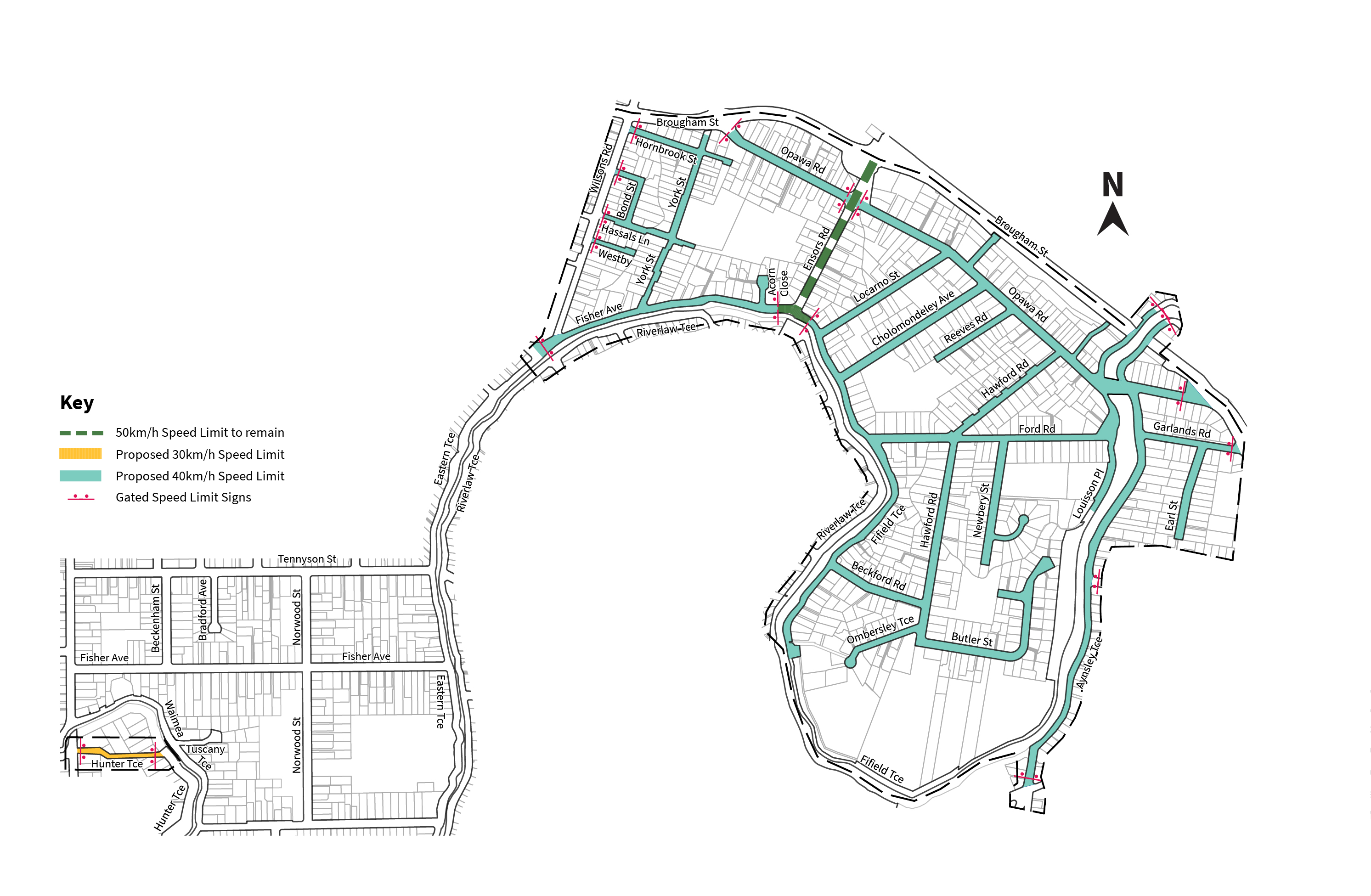
Opawa area speed plan
Supporting treatments for speed changes
Opawa area speed plan (downloadable) [JPG, 1.2 MB]
Supporting treatment for speed changes (downloadable) [PDF, 2.7 MB]
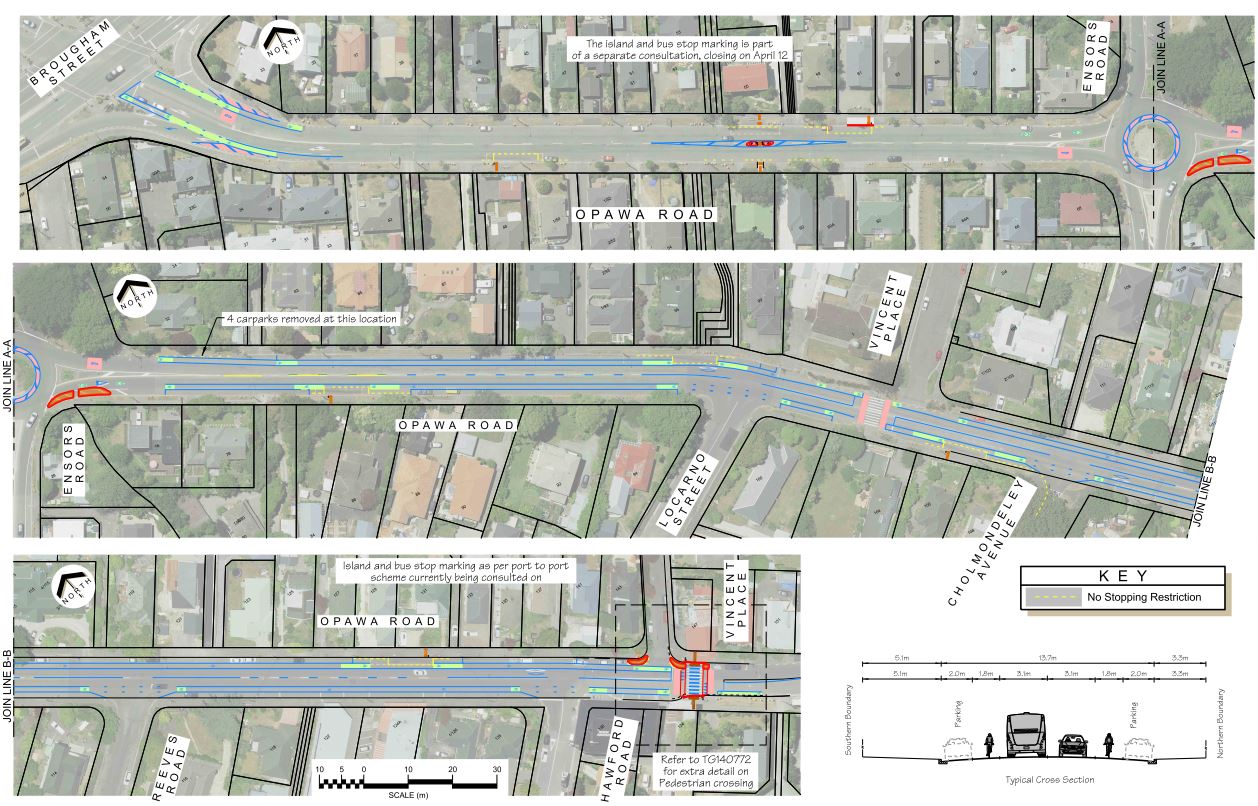
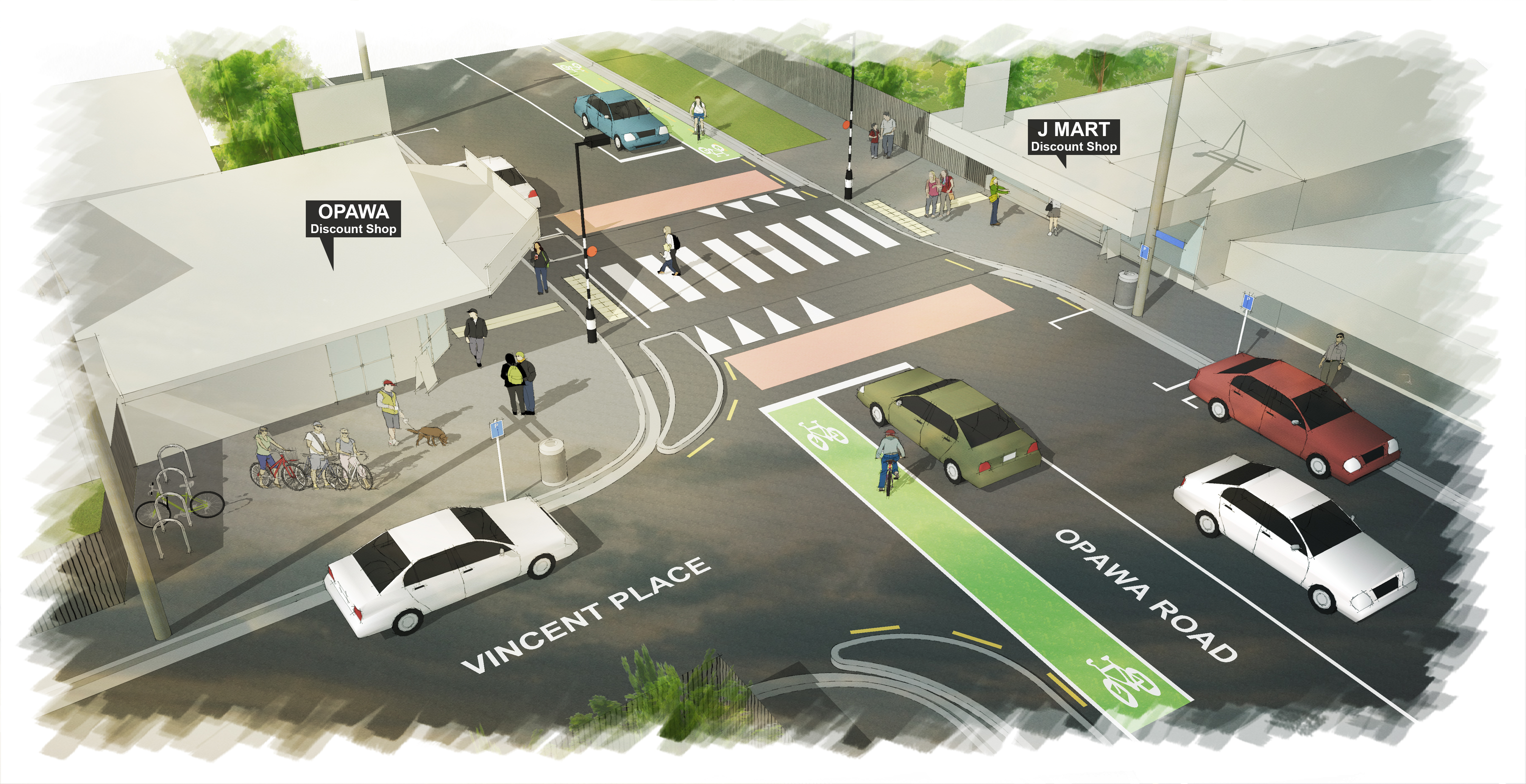
Opawa Road crossing
Concerns have been raised with Council a number of times regarding the safety of the Opawa shops pedestrian crossing on Opawa Road, near its intersection with Vincent Place. The main concerns relate to poor driver compliance with the zebra crossing, traffic speed, near misses and low-speed collisions.
The proposal is to:
- raise the flush crossing onto a platform,
- install red paint at the crossing in accordance with current best practice,
- install kerbside islands to reduce the crossing distance and improve visibility
Opawa Road crossing
Opawa Road crossing (downloadable) [JPG, 5.7 MB]
The main purpose “Slow Speed Neighbourhoods” is to create a safer and quieter street environment for all residents and road users. Slower speeds are expected to reduce the occurrence of crashes and their severity if they do occur. The OECD’s International Transport Forum Speed and Crash Risk report(external link) outlines the relationship between speed and crash occurrence and severity. It shows that if impact speed increases from 30 km/h to 40 km/h the risk of fatal injury to a pedestrian or cyclist is about doubled. Other internationally adopted research supports the recommendation that relatively small changes in speed can have a high impact on crash survival rates.
Feedback from residents is one of the main starting points. After receiving strong feedback from the residents of a certain locality/neighbourhood, staff investigate various other parameters like proximity to a high-speed location, presence of pedestrian generating activities nearby etc., to recommend a specific locality/neighbourhood for reduced speeds.
Christchurch City Council notify the Police through consultation and prior to a speed limit changing of the new limits. We typically do request that monitoring of the new speed limit is undertaken at Police discretion, however we have no control over Police resourcing/allocation of effort. Therefore, the task of increasing enforcement in the area sits with the Police. Council works closely with Police however and can raise this as a concern in this area.
Traffic calming measures such as speed humps are not specifically funded in Council’s Long Term Plan. The Minor Road Safety and Minor Safety Interventions programme budgets can potentially be used to fund traffic calming projects if there is a clearly defined road safety issue and/or crash history that needs to be addressed. However, most traffic calming projects often fall short when compared and prioritised against other candidate projects that need to be funded from these programme budgets. The idea is not to wait for crashes to happen. But, due to the availability of limited funding, locations with historically a higher number of injury crashes or higher crash risk need to be prioritised.
Various factors like crash history, crash risk, general vehicle operating speeds, existing road environment, nature of adjoining business or locations of interest. The available funding plays a role in deciding whether traffic calming can be warranted at any specific location.