We want to know your thoughts on the draft of the Ihutai-Estuary and Coastal Stormwater Management Plan
Project status: Closed for feedback
Open for feedback: 28 February 2022 to 26 April 2022
Share this
Consultation has now closed
Council approved the plan on 9 June 2022. You can view the meeting minutes, which include the formal resolutions, online at christchurch.infocouncil.biz(external link). You can also view the recording of the decision being made here.(external link)
Consultation on the Ihutai-Estuary and Coastal Draft Stormwater Management Plan has now closed. We accepted feedback between 28 February and 26 April 2022 and received 15 submissions. The table of consultation feedback is now available [PDF, 1.4 MB].
This draft Stormwater Management Plan sets out what we need to do in order to meet the conditions of the Comprehensive Stormwater Network Discharge Consent (CSNDC).
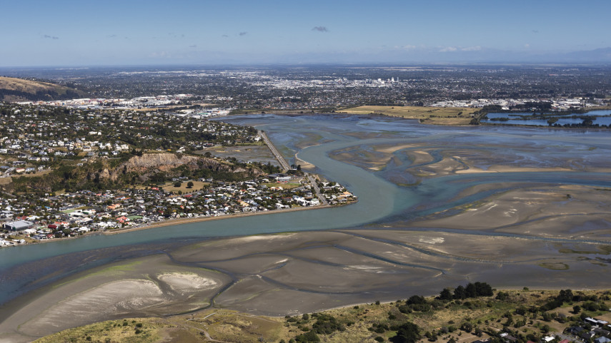
The Ihutai-Estuary & Coastal catchment spans the coastal fringe from Te Riu O Te Aika Kawa/Brooklands Lagoon to Godley Head. Two thirds of the catchment is coastal plains with the remainder made up by parts of the Port Hills. The area is 4,700 hectares.
The catchment includes Parklands, parts of North and South New Brighton, Linwood east of the central city, and Bromley. Port Hills areas include Mount Pleasant and Redcliffs, which drain into the estuary, and Clifton Hill, Sumner and Scarborough, which drain into the ocean.
Many waterways in the Ihutai-Estuary and Coastal catchment are rain fed and only flow when the weather is wet. More prominent rain fed waterways include the Sumner Stream, Charlesworth Drain, Mt Pleasant Waterway and Rifle Range Stream. The City Outfall Drain and Linwood Canal are fed by groundwater throughout the year.
Christchurch’s coastal plains were historically swampland or wet areas. Over time they have been drained by pipes taking stormwater to the shore. In populated hill areas most stormwater flows down road side channels into pipes and streams, or open concrete waterways
Purpose
The Ihutai-Estuary and Coastal Stormwater Management Plan has three key purposes:
- To meet the targets for lowering stormwater contaminants under the CSNDC
- To propose extra targets for lowering stormwater contaminants above and beyond the CSNDC
- To describe the ways stormwater discharges will be improved over time to meet environmental objectives.
Draft of the Ihutai-Estuary and Coastal Stormwater Management Plan
Cultural Impact Assessment
Water quality and ecological health
Ihutai-Estuary and Coastal catchment is a populated residential area and waterways are affected by urban land uses. Sediment from rural parts of the Port Hills also travels along waterways to the Ihutai.
Contaminants including bacteria and metals collect in the estuary, and the presence of nitrogen and phosphorus has caused excessive aquatic weed growth in the past. Their presence may still contribute to the amount of algae and weed in Ihutai.
During rainfall the City Outfall Drain, like many Christchurch urban spring-fed rivers, does not meet the indicator water quality values in the Land and Water Regional Plan.
Ihutai is recognised as a site of ecological significance in the Christchurch District Plan. It provides important feeding grounds for native migratory birds including the South Island pied oystercatcher, black-billed gull and white-fronted tern.
Flooding risks
Low lying houses in the catchment can be flooded in large rainfall events and some coastal streets experience tidal flooding. Land subsidence during the 2010/11 earthquakes has increased the flooding vulnerability of some properties.
Sea walls built to protect inland areas from waves and tidal waters can also have the effect of preventing the flow of stormwater away from low-lying areas. This can lead to ponding near the coast.
The Council has separately initiated a programme of coastal hazards adaption planning, dealing with sea level rise, tidal flooding and shoreline erosion. The first phase of work with communities will begin in Whakaraupō/Lyttelton Harbour in 2022.
Values
Water is a taonga (a treasured natural resource) and represents the lifeblood of the environment for tangata whenua. A relationship with the environment is central to Maori creation stories, spiritual belief, and ways to manage resources. Land, water and resources are a statement of identity. In a particular area, they relate to a group’s origin, history and tribal relationships. The whakapapa of a waterway would determine its use in tohunga (spiritual), waiwhakaheketupapaku (burial sites), waitohi (spiritual use), waimataitai (coastal mix of fresh and salt water, estuaries), waiora (spiritual healing water), and mahinga kai (food gathering).
The maintenance of water quality and quantity is perhaps the greatest resource management issue for tangata whenua. All waterways are a major feature within the landscape and should remain unmodified. Culturally, all waterways are significant and come together as one. Waterways begin as rain drops and connect together as streams, lakes, estuaries, and wetlands, all leading to the sea.
Ihutai (the Avon/Heathcote Estuary)
When tangata whenua first came to Ihutai it was an open bay. The spit at Te Karoro Karoro/New Brighton was likely formed following a change in position of the Waimakariri river between 1250-1500AD.
The Ihutai and Coastal area was extensively used by Ngāi Tahu whanau for mahinga kai. There are significant signs of occupation around Ihutai including former burial, horticultural and fishing areas. Many sites of occupation are associated with caves and rock-shelters along the northern slopes of the Port Hills. These include Te-Ana-o-Hineraki/Moa Bone Point Cave, Redcliffs flat and Moncks Cave. Multiple kāinga nohoanga (seasonal occupation sites) existed along the coastline of Te Tai o Mahaanui (the six local Rūnanga).
There were major Pā sites nearby; Puāri and Tautahi on the Ōtākaro River and Ōpāwaho on the Ōpāwaho River. Both of these rivers contributed to the abundant mahinga kai resources that Ihutai was renowned for.
Ihutai is the name of a mahinga kai reserve which formed part of the Crown’s land settlement with Ngāi Tahu in 1848. Ihutai Reserve was compulsorily purchased by the Christchurch Drainage Board in 1950 under the Public Works Act.
A cultural impact assessment of the Ihutai-Estuary and Coastal Draft Stormwater Management Plan has been carried out by Mahaanui Kurataio.
What we know about sediment
- Hillside earthworks are a major source
- Construction is a major source
- Rural Port Hills erosion is a significant source
- Road wear and vehicle tyres are believed to be a major source
- Cuttings and banks (road cuttings, old quarries, private sections) are a significant source
- Stormwater discharges to hillsides and hill waterways are a significant source
- Deposits from the atmosphere are a moderate source
- Stream-bank erosion can be a significant source in hill waterways
What we know about copper
- Vehicle brake-pads are a major source of copper
- Copper in rainfall contributes
- Soils are a minor to moderate contributor
- Small changes in the number of copper roofs can affect copper concentrations in stormwater
- Products used to clean roofs and pathways may contribute.
What we know about zinc
- Roofs are the source of maybe 65-70%+
- Tyres are the source of maybe 25-30%
- Other zinc-coated steel items (fences, ventilation ducts, poles) may produce 1 to 5%
- House & garden products (moss control) (some contribution).
Soil contributes to a small extent.
Our goals are:
- To ensure the quality of stormwater from all new development sites or re-development sites is treated to best practice.
- To have 100 per cent of stormwater treatment facilities built and operating to Waterways and Wetlands Design Guidelines standards.
- To have less than 5 per cent of all consented construction activities on the flat reported non-compliant due to sediment discharges – by 2025.
- To have less than 10 per cent of all consented construction activities on the Port Hills reported non-compliant due to sediment discharges – by 2025.
- To investigate ways to reduce the environmental effects of sediment discharges – by 2022.
- To look at options for carrying out street sweeping, sump cleaning, and send-to-wastewater trials – in 2022/23.
Recommended for the Surface Water Strategic Plan
- Plant severely eroding natural areas of the Port Hills from Sumner to Hoon Hay Valley.
- Put in place best-practice sediment controls on Port Hills roads and tracks – by 2025.
Reduce road sediment by the best practicable option determined by the results of street sweeping, sump cleaning and trialling alternative treatments.
Our goals are:
2.1 To have 100 per cent of stormwater treatment facilities constructed and conforming to Waterways and Wetlands Design Guidelines standards.
2.2 To investigate zinc mitigation measures and carry out cost/benefit analyses toward identifying their effectiveness as best practicable options – by 2022.
2.3 To consult with key stakeholders and identify a long-term zinc strategy in line with current technologies – by 2025.
2.4 To collaborate with local and regional government in a joint submission to central government seeking national measures and industry standards to reduce the discharge of contaminants from buildings and vehicles.
Recommended for the Surface Water Strategic Plan
2.5 By 2025, install a large-scale facility (or an array of devices, such as rain gardens) in at least one urban sub-catchment, to treat runoff from busy roads. By 2029, install similar facilities/devices in at least three urban sub-catchments
2.6 Adopt a strategy to limit zinc, based on finding the best practicable options.
2.7 Research and trial ways of trapping roof-sourced zinc on-site.
Our goals are:
3.1 To consult with the Government, through the Ministry for the Environment, about legislation to limit the copper content in vehicle brake pads.
3.2 To not permit stormwater discharges into the network from unprotected copper building cladding, spouting or downpipes.
3.3 To investigate a District Plan rule to discourage the use of copper building claddings.
Our goals are:
4.1 To compile a database of industrial sites considered to be medium or high risk based on the best available information – by 2025
4.2 To audit high-risk industrial sites by the approved procedure under the Comprehensive Stormwater Network Discharge Consent.
Our goals are:
5.1 To work with community groups to educate participants about current stormwater practice and to enable the public to take action to stop contaminants at source – by 2025.
5.2 To engage regularly with the Ministry for the Environment to collaborate on initiatives to reduce contaminants – by 2025.
Our goals are:
6.1 To limit the quantity of stormwater from all new development sites to pre-development levels, and minimise stormwater increases from re-development sites through consent conditions.
6.2 To protect houses from flooding during and after development by having controls on new floor levels.
6.3 Continue to improve flood models and our knowledge of flood risks.
Speak to staff about the draft Stormwater Management Plan
Please get in contact if you would like Council staff to attend a meeting to answer questions surrounding the draft Stormwater Management Plan.