We’re seeking your views on plans for improved cycling facilities as part of the South Express Major Cycle Route – Puari ki Niho-toto.
Project status: Decision made
Open for feedback: 25 January 2019 to 3 April 2019
Share this

Engagement on this project has now closed.
The Infrastructure, Transport and Environment Committee will be considering a staff report at their meeting on Monday 22 July 2019.
This report can be viewed online(external link) from Wednesday 17 July 2019.
At the close of consultation we received 642 submissions. We also undertook some additional targeted consultation on five small areas of the route. Feedback from all consultations is below.
Consultation report [PDF, 948 KB]
Design changes following consultation [PDF, 892 KB]
South Express MCR submissions(external link)
South Express MCR attachments(external link)
Elizabeth Street submissions [PDF, 491 KB]
Elizabeth Street attachments(external link)
Lochee Road submissions [PDF, 335 KB]
Lochee Road attachments(external link)
Craven Street submissions [PDF, 301 KB]
Taggart Place submissions [PDF, 323 KB]
Bus stop submissions [PDF, 290 KB]
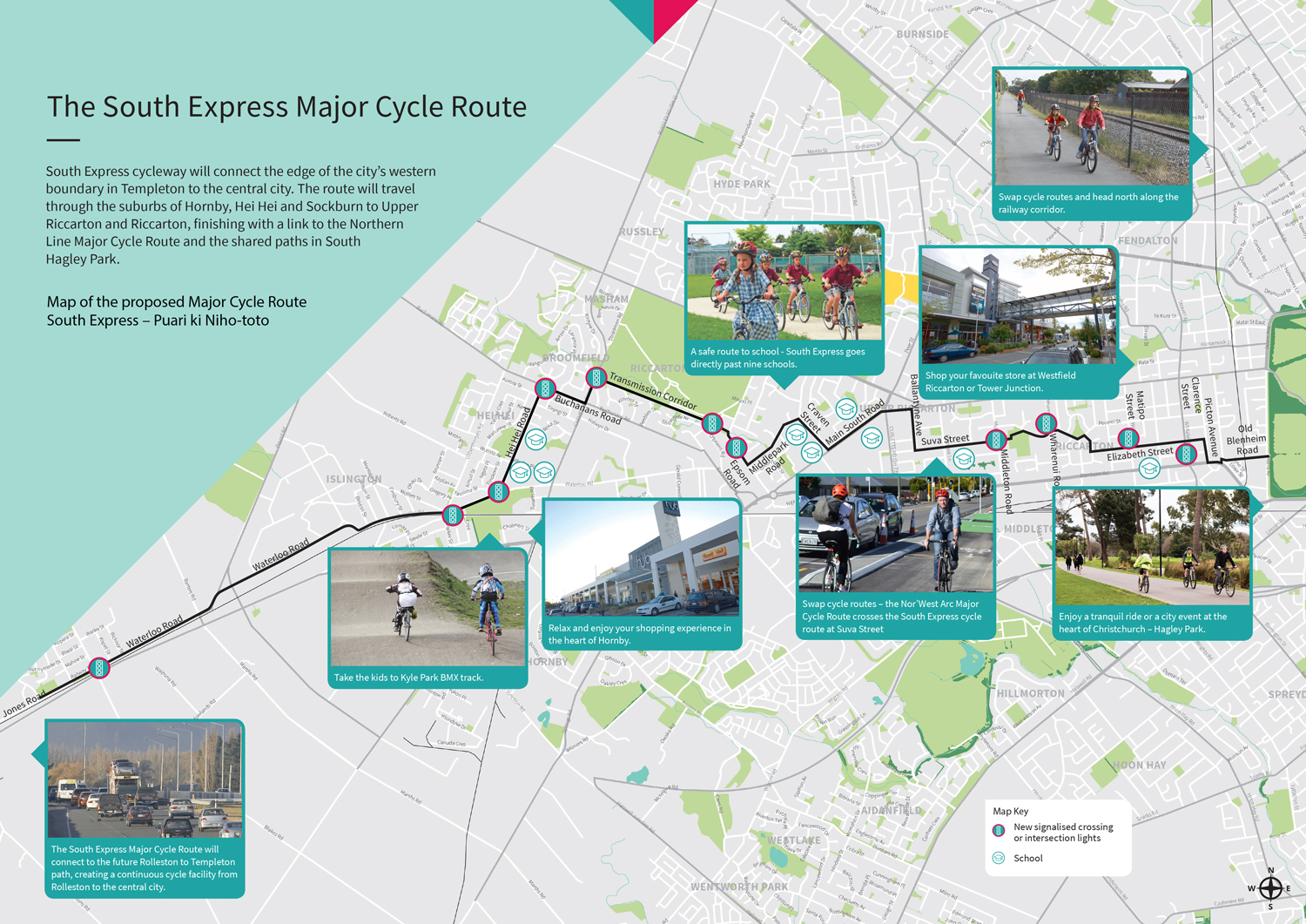
The South Express Major Cycle Route
South Express cycleway will connect the edge of the city’s western boundary in Templeton to the central city. The route will travel through the suburbs of Hornby, Hei Hei and Sockburn to Upper Riccarton and Riccarton, finishing with a link to the Northern Line Major Cycle Route and the shared paths in South Hagley Park.
Map of the proposed route [JPG, 1 MB]
In developing the South Express cycleway, we have developed a route that aims to balance safety, directness, access to destinations and impacts to stakeholders. We have looked at a number of different routes and types of cycleways. The route shown in this booklet is our preferred route and is considered to be the best option for providing a safe and comfortable link between Templeton and the city. The route provides excellent connections to several local schools in the area and aims to minimise impacts through major commercial and industrial areas.
Assessing the options
There are a number of factors that determine the best route for a cycleway. To ensure that all of these factors are considered, we have developed a process to help identify a preferred option. This process is designed to provide a balance between the needs of people wanting to cycle and the impacts of a cycleway on businesses, residents and the road network. For the South Express cycleway, a number of route options were initially identified and assessed.
Criteria considered:
Safety first
For the cycleways to be effective and feel safe, the Major Cycle Routes must be built in a certain way. This means separating people on bikes from motor vehicles in some areas, and slowing vehicles and reducing volumes in others.
Generally, the preferred location for Major Cycle Routes is on quieter streets with fewer trucks. However, this can be difficult to achieve where the route gets close to busy urban destinations and / or needs to link through commercial areas.
Between Hornby and Sockburn, we have selected a more northerly route that runs along the transmission corridor beside Riccarton Raceway. This is a safe, off-road route that avoids busy traffic areas, including heavy trucks through Hornby.
Traffic network considerations
Building safe cycle routes is one way to make the transport network more resilient. Where the proposed cycle route significantly changes the road, we must assess the likely impact on the rest of the transport network. In some cases plans for the route have been amended to avoid causing significant traffic delays and congestion elsewhere.
Our preferred route is generally located along local streets away from busy arterial roads that are designed to carry high volumes of vehicle traffic. This will require some changes to local access in Riccarton to help make streets and intersections safer for people to use by bike, as well as on foot. This will also reduce through traffic on some of these local streets. Residents’ access has been considered as part of these designs.
Business impacts
We recognise that existing parking is very important, particularly for local shops which rely on passing custom. Where possible, we have retained existing restricted parking zones and with some exceptions, have proposed alternative restricted on-street parking close by.
Along Peverel Street and Elizabeth Street, the cycleway is separated and requires space that will reduce the amount of on-street parking outside businesses. Parking on side streets and time restricted on-street parking is provided.
We aren’t making any changes to parking in the business park.
Residential impacts
We are aware of the need to balance different travel needs including parking, and we have carefully considered options to keep as much parking as possible.
However, when planning safe, direct cycleways using limited available space, there will be times when vehicle parking does not take priority.
The majority of the route goes through streets with low parking demand. Parking removal has been minimised, particularly in areas of high parking demand, such as Elizabeth Street and Picton Avenue.
What about tree removal?
In some areas we will need to remove trees to make room for the cycleway, and to improve safety by increasing visibility of the cycleway as people come out of their driveways or travel along the road. Trees to be removed will be replaced in suitable locations nearby.
Along the whole route we have identified approximately 65 trees that will need to be removed, 21 of these are within the Transmission Corridor. Replacement trees will be planted close by once we have determined the location of underground services.
Connecting with the central city and other Major Cycle Routes
South Express cycleway will have a direct connection with the Nor’West Arc in Riccarton and the Northern Line at the eastern end of the route. It continues through South Hagley Park to connect to the central city cycleways along Tuam and St Asaph streets.
The South Express route from Templeton to the Central City can be broken down into four sections:
- Templeton – from Globe Bay Drive to Gilberthorpes Road
- Hornby – from Gilberthorpes Road to Racecourse Road
- Sockburn – from Racecourse Road to Curletts Road
- Riccarton – from Curletts Road to South Hagley Park
Route options for each section have been assessed against the criteria detailed above, to determine the best route for each section, while keeping in mind how the sections fit together to form a continuous route.
Globe Bay Drive to Gilberthorpes Road (Templeton)
Three options were identified within this section. The preferred route starts at Globe Bay Drive and heads east along Jones Road and Railway Terrace and crosses Kirk Road. It continues east along Waterloo Road, through the Waterloo Business Park to the intersection of Gilberthorpes Road.
This route passes through the busy commercial and industrial zone of Waterloo Business Park.
An alternative route utilising the rail corridor behind Waterloo Business Park, from Pound Road to the realigned Halswell Junction Road, was not viable due to existing and proposed railway sidings being unsafe for cyclists as determined by KiwiRail.
Another alternative connection through the Templeton Park subdivision required the removal of on-street car parking and provided less connectivity to the proposed future route from Rolleston.
Gilberthorpes Road to Racecourse Road (Hornby)
The preferred route continues on Waterloo Road adjacent to Kyle Park before heading up Hei Hei Road to Buchanans Road. The route then travels along the north side of Buchanans Road, before running along the west side of Carmen Road to a crossing point at Masham Reserve to link with the transmission pylon corridor. The cycleway would then continue along the pylon corridor adjacent to the boundary of Riccarton Racecourse through to Racecourse Road.
This route provides a safe and attractive environment for cyclists along a combination of lower volume local roads and off-road paths. The route provides good connections to Hornby High, Hornby Primary and St Bernadettes schools. It will also provide a useful link from the Hei Hei residential area to The Hub Hornby via Kyle Park. The development of a shared path along the transmission corridor will also offer a recreational use that will pass by several small parks and reserves in the area.
We recognise that this route is not as direct as other on-road alternatives through this section, including the use of Waterloo or Main South Roads. However, these options require cyclists to ride through busy commercial and industrial zones where higher traffic volumes and more trucks result in an unsafe and uncomfortable environment. Safety must always be the top priority to encourage more people to cycle.
Racecourse Road to Curletts Road (Sockburn)
Six different route options were considered to continue the South Express onwards through Sockburn. The preferred route travels east along the transmission pylon corridor through Pararoa Stream Reserve. On reaching Epsom Road, the route continues south to Middlepark Road, travelling past St Thomas’ College to Craven Street, where it links to Main South Road. The cycleway proceeds for a short length along the north side of Main South Road, crossing at the existing mid-block signal crossing outside Riccarton High School, before continuing along the south side to Curletts Road.
Out of all options considered, this is the safest, most attractive and comfortable route. It generally avoids arterial roads, including the busy Sockburn roundabout, which is difficult to negotiate for even the most experienced cyclists.
The route minimises the length of biking required on the Main South Road and also provides an excellent connection to Riccarton High, St Thomas’, Riccarton Primary and Our Lady of Victories Schools.
Curletts Road to South Hagley Park (Riccarton)
Through this section, five different route options were considered to continue the South Express towards the central city. Two of these routes were discounted early; Riccarton Road along the northern extent (which has a bus priority focus) and a southern route utilising Lunns, Annex, Birmingham and Wrights Road (due to its close proximity to the Little River and Nor’West Arc Major Cycle Routes).
The preferred option is based on a local road route through the Riccarton residential area. Beginning at Curletts Road, this option travels a short section on Main South Road to a walkway linking to Ballantyne Avenue. The route then connects to Suva Street where it continues past Middleton Grange School and around Middleton Park to Lochee Road. At Wharenui Road, the cycleway travels via Peverel Street and Centennial Avenue before linking to Elizabeth Street through to Picton Avenue. A short section of travel is required on Picton Avenue before linking to the Old Blenheim Road alignment across Mandeville Street to the Northern Line MCR and South Hagley Park. There is a alternative option which utilised Peverel Street instead of Elizabeth Street but this was discounted due to of significantly higher traffic volumes and on-street parking demand in close proximity to Westfield Mall.
Peverel Street instead of Elizabeth Street but this was discounted in recognition of significantly higher traffic volumes and on-street parking demand in close proximity to Westfield Mall.Although less direct than some other options, the preferred route along quieter local roads is safe, attractive and comfortable. There are good connections to Middelton Grange and Wharenui School and a direct link into Riccarton High School. The route passes by the Wharenui Recreation Centre and is close to key Riccarton activity areas. There are also good connections to greenspace at Middleton and Harrington Parks.
The other two routes considered were:
Blenheim Road
While this route is direct, Blenheim Road is a busy major arterial with freight and public transport services making it less desirable for a Major Cycle Route. A cycleway with protected facilities would also impact on the efficiency at several busy intersections along Blenheim Road, increasing delay to traffic (in order to provide protected signal phasing for cyclists) on this key transport route.Transmission Corridor
The pylon corridor offers a relatively direct off-road route, however discussions with Transpower identified that the corridor was not viable for a Major Cycle Route due to existing lease and sale negotioations with adjacent landowners. There were also personal safety and security concerns for cycleway users.

Waterloo, Gilberthorpes and Waterloo

Ballantyne Avenue cul-de-sac at Suva Street

Elizabeth Street cul-de-sac at Wainui Street

Elizabeth Street/Division Street realignment

Elizabeth St cul-de-sac at and new signalised intersection
A cul de sac is proposed to maximise the on-street parking available in that section of the street. It will create an area for landscaping and prevent a desirable shortcut route for vehicles trying to avoid congestion on Riccarton Road and Blenheim Road. It has the advantage of decreasing the traffic volume on the street which will make it safer for cyclists and quieter for residents.
Detailed cycleway maps
Jones Road (sheet 1) - plans below
Key features of the proposed cycleway on this section of Jones Road:
- A 3m wide shared path runs along the northern side of Jones Road, from Jones Reserve entrance by Globe Bay Drive to a crossing point over Jones Road.
- After the crossing, the path continues east along the southern side of Jones Road, partially within the rail corridor (extent to be confirmed).
The South Express Major Cycle Route will connect to the future Rolleston to Templeton path, creating a continuous cycle facility from Rolleston to the central city.
Jones Road and Railway Terrace (sheet 2)
Key features of the proposed cycleway on this section of Jones Road and Railway Terrace:
- A 3m wide shared path continues along the southern side of Jones Road and Railway Terrace.
- Some trees and plantings may need to be removed to fit the path, however replacements will be planted wherever possible.
An option to continue the shared path straight through the reserve area was considered, however there were concerns that people may not feel comfortable using the path at certain times due to it being hidden from public view.
Railway Terrace, Kirk Road and Waterloo Road (sheet 3)
Key features of the proposed cycleway on this section of Railway Terrace, Kirk Road and Waterloo Road:
- A 3m wide shared path continues along the southern side of Railway Terrace, widening to 4m adjacent to on-street parking.
- Some trees and plantings may need to be removed to fit the path, however replacements will be planted wherever possible.
- A new signalised crossing over Kirk Road will enable people travelling on foot or by bike to safely cross the road. The shared paths provided on each side of the road will require the removal of some on-street parking on Kirk Road, Railway Terrace and Waterloo Road.
- The shared path continues east along the northern side of Waterloo Road. To provide visibility and adequate width for the path, on-street parking adjacent to it will need to be removed.
- The shared path will cross over Waterloo Road at a new crossing point.
- East of the crossing, the shared path continues on the southern side of Waterloo Road, partially within the rail corridor (extent to be confirmed).
The angle of the signalised crossing on Kirk Road makes it smoother for people cycling to manoeuvre around and avoids the stormwater chambers on the western side. The operation of the crossing will be co-ordinated with the rail crossing.
Waterloo Road (Sheet 4)
Key features of the proposed cycleway on this section of Waterloo Road:
- A 3m wide shared path continues along the southern side of Waterloo Road, partially within the rail corridor (extent to be confirmed).
- Crossing points will help people access the shared path from Kissel and Bicknor Streets. This requires the removal of some on-street parking to give people crossing the road adequate visibility to oncoming vehicles.
- Some trees and plantings may need to be removed to fit the path, however replacements will be planted wherever possible.
Waterloo Road (sheet 5)
Key features of the proposed cycleway on this section of Waterloo Road:
- A 3m wide shared path continues along the southern side of Waterloo Road, partially within the rail corridor (extent to be confirmed).
The proposed path alignment runs between the two rows of power poles, away from both the road and the railway.
Waterloo Road (sheet 6)
Key features of the proposed cycleway on this section of Waterloo Road:
- A 3m wide shared path continues along the southern side of Waterloo Road, partially within the rail corridor (extent to be confirmed).
Waterloo Road (sheet 7)
Key features of the proposed cycleway on this section of Waterloo Road:
- A 3m wide shared path joins into the 2.5m wide shared path recently constructed as part of the State Highway 1 Barters Road/Pound Road improvements.
- Confident riders who do not wish to mix with pedestrians on the shared path can use the 1.8m wide on-road painted cycle lanes.
Waterloo Road (sheet 8)
Key features of the proposed cycleway on this section of Waterloo Road:
- The 2.5m wide shared path recently constructed as part of the State Highway 1 Barters Road/Pound Road improvements continues through the realigned Pound Road intersection, where a cycle and pedestrian crossing has been constructed.
- Confident riders who do not wish to mix with pedestrians on the shared path can use the 1.8m wide, on-road painted cycle lanes.
- Both shared paths and painted cycle lanes connect to State Highway 1 along Pound Road.
The State Highway 1 Barters Road/Pound Road improvements were completed in 2018.
Waterloo Road (sheet 9)
Key features of the proposed cycleway on this section of Waterloo Road:
- The 2.5m wide shared path recently constructed as part of the Waterloo Business Park continues along the new Waterloo Road alignment.
- Confident riders who do not wish to mix with pedestrians on the shared path can use the 1.8m wide, on-road painted cycle lanes.
No changes to the Waterloo Business Park roads are proposed as part of this project. The existing road layout is shown for information only.
Waterloo Road (sheet 10)
Key features of the proposed cycleway on this section of Waterloo Road:
- The 2.5m wide shared path recently constructed as part of the Waterloo Business Park continues along the new Waterloo Road alignment.
- Confident riders who do not wish to mix with pedestrians on the shared path can use the 1.8m wide, on-road painted cycle lanes.
A separated cycleway may be considered in the future when the number of cycleway users has increased and the number and nature of vehicle accesses along the route are better understood. Given the low pedestrian numbers, this existing configuration is considered suitable in the short to medium term.
Waterloo Road (sheet 11)
Key features of the proposed cycleway on this section of Waterloo Road:
- The 2.5m wide shared path recently constructed as part of the Waterloo Business Park continues along the new Waterloo Road alignment.
- Confident riders who do not wish to mix with pedestrians on the shared path can use the 1.8m wide, on-road painted cycle lanes.
- Shared path users will deviate to a safe crossing point on Enterprise Avenue, away from Waterloo Road.
Signage and markings along the shared path will be added and improved as part of the Major Cycle Route.
Waterloo Road (sheet 12)
Key features of the proposed cycleway on this section of Waterloo Road:
- The 2.5m wide shared path recently constructed as part of the Waterloo Business Park continues along the new Waterloo Road alignment.
- Confident riders who do not wish to mix with pedestrians on the shared path can use the 1.8m wide, on-road painted cycle lanes.
- At the Halswell Junction Road roundabout, the cycle route will cross to the southern side of Waterloo Road via crossing points around the roundabout.
- Shared paths and cycle lanes will provide links further north along Halswell Junction Road as the business park is developed further.
Signage and markings along the shared path will be added and improved as part of the Major Cycle Route.
Waterloo Road (sheet 13)
Key features of the proposed cycleway on this section of Waterloo Road:
- A recently-constructed 3m wide shared path continues down the western side of the realigned Waterloo Road.
- A new signalised intersection to be constructed as part of the Halswell Junction Road realignment (consulted on in 2017) will cross cycleway users over the new Halswell Junction Road to the southern side of Waterloo Road.
- A 3m wide shared path runs along the southern side of Waterloo Road, adjacent to the railway corridor.
The Halswell Junction Road realignment is a separate project to the South Express Major Cycle Route. Connections for cycleway users have been included in its design.
Waterloo Road (sheet 14)
Key features of the proposed cycleway on this section of Waterloo Road:
- A 3m wide shared path runs along the southern side of Waterloo Road, adjacent to the railway corridor.
- On-street parking on the southern side of Waterloo Road will need to be removed to fit the new path.
- Crossing points adjacent to side roads will help people to access the path from the surrounding area. Some on-street parking on the northern side of Waterloo Road will need to be removed to make it easier for people crossing the road to see oncoming vehicles.
- Existing vegetation near the path will be removed and replaced with low plantings to create a safer environment for people using the path.
- Halswell Junction Road will no longer intersect Waterloo Road at this location following its future realignment. It will be closed to pedestrians and vehicles.
Removing large shrubs and other vegetation near paths can make people using the paths feel safer by giving them a clear view of their surroundings.
Waterloo Road (sheet 15)
Key features of the proposed cycleway on this section of Waterloo Road:

Artist impression: Waterloo Road
- A 3m wide shared path runs along the southern side of Waterloo Road, adjacent to the railway corridor.
- Some on-street parking on the southern side of Waterloo Road will need to be removed to fit the new path.
- Near the local shops, the shared path will move to be partially within the rail corridor. This will allow on-street parking on both sides of the road to be maintained (parking on both sides will be parallel parking). The shared path will widen to 4m wide next to the parking to allow for car door movements.
- Crossing points adjacent to side roads will help people to access the path from the surrounding area. Some on-street parking on the northern side of Waterloo Road is removed to make it easier for people crossing the road to see oncoming vehicles.
- Existing vegetation near the path will be removed and replaced with low plantings to create a safer and more comfortable environment for people to walk and cycle along the path.
")
Jones Road (sheet 1)
")
Jones Road and Railway Terrace (sheet 2)
")
Railway Terrace, Kirk Road and Waterloo Road (sheet 3)
")
Waterloo Road (sheet 4)
")
Waterloo Road (sheet 5)
")
Waterloo Road (sheet 6)
")
Waterloo road (sheet 7)
")
Waterloo road (sheet 8)
")
Waterloo Road (sheet 9)
")
Waterloo Road (sheet 10)
")
Waterloo Road (sheet 11)
")
Waterloo Road (sheet 12)
")
Waterloo Road (sheet 13)
")
Waterloo Road (sheet 14)
")
Waterloo Road (sheet 15)
Waterloo Road (Gilberthorpes Road intersection) (sheet 16) - plans below
Key features of the proposed cycleway on this section of Waterloo Road:
- A signalised crossing over Parker Street allows people walking and cycling to cross through this busy intersection.
- Closing access from Moffett Street onto Gilberthorpes Road will simplify the road layout, making it safer for all road users.
- Left turns from Gilberthorpes Road into Waterloo Road will no longer be permitted for heavy vehicles (over 3,500 kg). This is to provide a safer crossing point for people crossing Waterloo Road on foot by making the corner tighter and slower for vehicles.
- West of Gilberthorpes Road, a 4m wide shared path runs along the southern side of Waterloo Road, adjacent to the railway corridor.
- East of Gilberthorpes Road, a 5m wide shared path runs for a short length before transitioning cyclists to a separated cycleway.
- A 3m wide two-way separated cycleway continues east along the southern side of Waterloo Road.
- On-street parking on the southern side of Waterloo Road will need to be removed to fit the cycleway as well as providing enough lane width for heavy vehicles. Some on-street parking will also need to be removed from the northern side, close to Gilberthorpes Road.
Waterloo Road (sheet 17)
Key features of the proposed cycleway on this section of Waterloo Road:
- A 3m wide two-way separated cycleway continues east along the southern side of Waterloo Road, up until the western extent of Kyle Park. On-street parking on the southern side of Waterloo Road, next to the cycleway, will need to be removed to fit the cycleway as well as providing enough lane width for heavy vehicles.
- Outside Kyle Park, the cycleway will transition to a 4m wide shared path, partially within Kyle Park. This allows on-street parking to be retained on both sides of Waterloo Road.
- The pedestrian crossing point west of Taurima Street is improved, which requires the removal of a small amount of on-street parking.
Widening the shared path into Kyle Park avoids the need to change the road layout.
Waterloo Road and Hei Hei Road (sheet 18)
Key features of the proposed cycleway on this section of Waterloo Road and Hei Hei Road:
- A 4m wide shared path, partially within Kyle Park, runs along the southern side of Waterloo Road. This allows on-street parking to be retained on both sides of Waterloo Road.
- The intersection of Taurima Street / Waterloo Road is narrowed with a raised platform added, making it safer and improving crossing points for people crossing the road on foot. This requires the removal of some on-street parking on both sides of Waterloo Road.
- At Hei Hei Road, a signalised crossing will enable people walking and cycling to cross Waterloo Road and continue along the Major Cycle Route. Access to local destinations including Kyle Park and Hornby Primary School will also be improved.
- North of Waterloo Road, the shared path will transition cycleway users to a 3.5m wide two-way separated cycleway. On-street parking on the eastern side of Hei Hei Road will need to be removed to fit the cycleway.
- A new refuge island will help people cross between Taurima Street and the new shared path opposite the access to Kyle Park.
Having the signalised crossing on the eastern side of Hei Hei Road makes it the most useful for students walking and cycling to the schools in the area.
Hei Hei Road (sheet 19)
Key features of the proposed cycleway on this section of Hei Hei Road:

Artist impression: Hei Hei Road
- A 3.5m wide two-way separated cycleway runs along the eastern side of Hei Hei Road. On-street parking on the eastern side of Hei Hei Road will need to be removed to fit the cycleway.
- The intersections of Wycola Avenue and Whelan Place with Hei Hei Road are narrowed, making them safer and improving crossing points for pedestrians. This requires the removal of some on-street parking around Wycola Avenue. A raised platform on Whelan Place will slow vehicles as they approach the cycleway.
- A low-speed shared area at the zebra crossing will enable the school patrol to continue operating with the cycleway. A pedestrian fence in front of the ABC Learning Centre will help prevent people from walking or running straight out onto the shared area from the Centre.
Having the cycleway on the eastern side avoids the busier side roads and connects well with crossings over Waterloo Road and Buchanans Road.
Hei Hei Road (sheet 20)
Key features of the proposed cycleway on this section of Hei Hei Road:
- A 3.5m wide two-way separated cycleway runs along the eastern side of Hei Hei Road. On-street parking on the eastern side of Hei Hei Road will need to be removed to fit the cycleway.
- The existing refuge island is shifted to the west to fit the cycleway. This requires a length of on-street parking on the western side of Hei Hei Road to be removed. A refuge will also be provided between the cycleway and traffic lanes.
- The school bus stop is relocated to provide the best visibility for people crossing the road and entering and exiting carparks.
It is legal to use a painted median to pass a stationary vehicle. The maximum legal speed at which vehicles on either of the road may pass a stopped school bus is 20 km/h.
Hei Hei Road (sheet 21)
Key features of the proposed cycleway on this section of Hei Hei Road:
- A 3.5m wide two-way separated cycleway runs along the eastern side of Hei Hei Road. On-street parking on the eastern side of Hei Hei Road will need to be removed to fit the cycleway.
- The existing refuge island is shifted to the west to fit the cycleway. This requires a length of on-street parking on the western side of Hei Hei Road to be removed. A refuge will also be provided between the cycleway and traffic lanes.
- The school bus stop is relocated to provide the best visibility for people crossing the road and entering and exiting carparks.
It is legal to use a painted median to pass a stationary vehicle. The maximum legal speed at which vehicles on either of the road may pass a stopped school bus is 20 km/h.
Hei Hei Road and Buchanans Road (sheet 22)
Key features of the proposed cycleway on this section of Hei Hei Road and Buchanans Road:
- A 3.5m wide two-way separated cycleway runs along the eastern side of Hei Hei Road. On-street parking on the eastern side of Hei Hei Road will need to be removed to fit the cycleway.
- Approaching Buchanans Road, the cycleway transitions to a shared path to fit the bus stops and continue the Major Cycle Route around the corner onto Buchanans Road.
- A new signalised crossing over Buchanans Road will enable people travelling on foot or by bike to safely cross. This will require the removal of some on-street parking on Buchanans Road.
- A refuge island on Hei Hei Road will help people cross to the new shared path and signalised crossing.
- People cycling will be able to ride along a new 3.5m wide cycleway on the wide berm alongside Buchanans Road. This will require some trees to be removed, however replacements will be planted where possible.
Experience shows it is best to keep the cycle path at least 3 metres from property boundaries, to give drivers exiting properties the best chance to see approaching cyclists. This distance can be reduced where there are sections of path with no driveways on them.
Buchanans Road (sheet 23)
Key features of the proposed cycleway on this section of Buchanans Road:
- A 3.5m wide two-way cycleway runs along the wide berm alongside Buchanans Road. This will require some trees to be removed, however replacements will be planted where possible.
- A refuge island on Vanguard Drive will help people walking and cycling to cross. Some on-street parking along Vanguard Drive will need to be removed to give people crossing good visibility of approaching vehicles.
- Approaching Carmen Road, the cycleway and footpath will join to form a shared path. This will connect into the existing 3m wide shared path on the western side of Carmen Road.
Carmen Road (sheet 24)
Key features of the proposed cycleway on this section of Carmen Road:
- The Major Cycle Route will run along the existing 3m wide shared path on the western side of Carmen Road.
- A signalised crossing for people walking and cycling will be provided at the existing pedestrian crossing point near the bus stops. As a staggered crossing, this can be coordinated with nearby signalised intersections to reduce the delay to vehicles.
- On the eastern side of Carmen Road, a shared path continues around into the transmission corridor, running next to the pylons.
- Some existing bushy trees will need to be removed to create a safer and more comfortable environment for people to walk and cycle along the path. They will be replaced with more appropriate species.
Removing large shrubs and other vegetation near paths can make users feel safer by giving them a clear view of their surroundings.
Transmission Corridor (sheet 25)
Key features of the proposed cycleway on this section of the transmission corridor:
- A 4m wide shared path continues through the transmission corridor.
- The path will connect onto Zenith Place, as well as the future Karamū Riccarton Park subdivision.
Transmission Corridor (sheet 26)
Key features of the proposed cycleway on this section of the transmission corridor:
- A 4m wide shared path continues through the transmission corridor.
- The path will run past the future Karamū Riccarton Park subdivision.
- Some trees will need to be removed to fit the new shared path. These will be relocated or replaced at a more suitable location, where possible.
Transmission Corridor (sheet 27)
Key features of the proposed cycleway on this section of the transmission corridor:
- A 4m wide shared path continues through the transmission corridor.
- Some existing bushy trees and shrubs will need to be removed to create a safer and more comfortable environment for people to walk and cycle along the path.
- A 4m wide timber bridge over the Paparua Stream will allow the path to continue down the transmission corridor.
Removing large shrubs and other vegetation near paths can make people using the paths feel safer by giving them a clear view of their surroundings.
 (Sheet 16)")
Waterloo Road (Gilberthorpes Road intersection) (Sheet 16)
")
Waterloo Road (sheet 17)
")
Waterloo Road and Hei Hei Road (sheet 18)
")
Hei Hei Road (sheet 19)
")
Hei Hei Road (sheet 20)
")
Hei Hei Road (sheet 21)
")
Hei Hei Road and Buchanans Road (sheet 22)
")
Buchanans Road (sheet 23)
")
Carmen Road (sheet 24)
")
Transmission Corridor (sheet 25)
")
Transmission Corridor (sheet 26)
")
Transmission Corridor (sheet 27)
Transmission Corridor and Paparua Stream Reserve (sheet 28) - plans below
Key features of the proposed cycleway on this section of the transmission corridor and Paparua Stream Reserve:
- A 4m wide shared path continues through the transmission corridor.
- A signalised crossing over Racecourse Road allows path users to continue along a shared path in Paparua Stream Reserve. This requires the removal of some on-street parking on Racecourse Road.
- The existing path through Paparua Stream Reserve will be widened to 4m wherever possible, however space constraints mean that some sections, including bridges, will remain at a narrower width.
Paparua Stream Reserve and Epsom Road (sheet 29)
Key features of the proposed cycleway on this section of Paparua Stream Reserve and Epsom Road:
- A 4m wide shared path continues through the Paparua Stream Reserve.
- A 3m wide two-way separated cycleway runs along the western side of Epsom Road from where the cycleway commences at the corner to a point near Ashtead Lane.
- A signalised crossing for people walking and cycling, near Ashtead Lane, crosses the cycleway to the eastern side of Epsom Road.
- On-street parking next to the cycleway will need to be removed to fit the cycleway as well as to provide enough lane width for heavy vehicles.
The cycleway crosses Epsom Road at this point as it has good visibility and avoids crossing commercial accesses, while also having space on each side of the road clear of driveways for the crossing and traffic signal poles.
Epsom Road and Middlepark Road (sheet 30)
Key features of the proposed cycleway on this section of Epsom Road and Middlepark Road:
- A 3m wide two-way separated cycleway continues along the eastern side of Epsom Road. On-street parking next to the cycleway will need to be removed to fit the cycleway as well as providing enough lane width for heavy vehicles.
- The cycleway will continue around the corner into Middlepark Road, where crossing improvements for pedestrians will also be made.
- A 3.5m wide two-way separated cycleway runs along the northern side of Middlepark Road. On-street parking next to the cycleway will need to be removed to fit the cycleway as well as to provide enough lane width for vehicle movements.
- Buses travelling east will stop in the traffic lane at the bus stop, which may require vehicles following the bus to wait for a short time. This arrangement allows on-street parking opposite the bus stop to remain.
- The existing speed hump is shifted approximately 30m south-west to move it away from the new cycleway bus stop configuration.
Bus stops alongside separated cycleways feature a raised island between the bus stop and the cycleway. Passengers will step on and off the bus from the raised island.
Middlepark Road (sheet 31)
Key features of the proposed cycleway on this section of Middlepark Road:
- A 3.5m wide two-way separated cycleway runs along the northern side of Middlepark Road. On-street parking next to the cycleway will need to be removed to fit the cycleway as well as to provide enough lane width for vehicle movements.
Middlepark Road (sheet 32)
Key features of the proposed cycleway on this section of Middlepark Road:
 Artist impression: Middlepark Road
- A 3.5m wide two-way separated cycleway runs along the northern side of Middlepark Road. On-street parking next to the cycleway will need to be removed to fit the cycleway as well as to provide enough lane width for vehicle movements.
- The intersection of Takaro Avenue with Middlepark Road is narrowed, with a raised platform added, to make it safer and improve crossing points for pedestrians. This requires the removal of some on-street parking around the intersection.
- The cycleway will cross to the southern side of Middlepark Road at the bend by St Thomas of Canterbury College via a shared path area. This will improve the crossing for people crossing the road on foot, as well as by bike.
- To provide adequate visibility for people crossing the road, the existing bus stop and shelter outside St Thomas Sports Grounds will need to be relocated approximately 60m. The new bus stop will be located outside No. 1 McClintock Lane.
- The 3.5m wide two-way separated cycleway continues along the southern side of Middlepark Road. On-street parking next to the cycleway will need to be removed to fit the cycleway as well as to provide enough lane width for vehicle movements.
The Major Cycle Route crossing will improve safety for people crossing Middlepark Road on foot as well as by bike.
Middlepark Road and Craven Street (sheet 33)
Key features of the proposed cycleway on this section of Middlepark Road and Craven Street:
- The 3.5m wide two-way separated cycleway continues along the southern side of Middlepark Road. On-street parking next to the cycleway will need to be removed to fit the cycleway as well as to provide enough lane width for vehicle movements.
- At the intersection with Craven Street, the existing roundabout will be modified to accommodate the cycleway continuing around the corner onto Craven Street. Some on-street parking on both Middlepark Road and Craven Street will need to be removed to accommodate this.
- A 3.5m wide two-way separated cycleway continues along the western side of Craven Street. There is little opportunity to retain on-street parking adjacent to the cycleway along this section of Craven Street. The available width has therefore been used to maintain the width of the cycleway and traffic lanes.
Parking adjacent to separated cycleways needs to be set back from driveways to help drivers see cyclists potentially obscured by parked vehicles. There is therefore little opportunity to retain on-street parking adjacent to the cycleway along this section of Craven Street.
Craven Street and Main South Road (sheet 34)
Key features of the proposed cycleway on this section of Craven Street:
- The 3.5m wide two-way separated cycleway narrows to 3m south of Algidus Street, at which point the traffic lanes also narrow, meaning on-street parking on both sides of the road can be provided in the area surrounding Our Lady of Victories School.
- Buses travelling north will stop in or partially within the traffic lane at the bus stops, which may require vehicles following the bus to queue for a short time. This arrangement allows on-street parking to remain on the eastern side of the road, opposite the bus stops.
- The intersection of Algidus Street with Craven Street is narrowed, with a raised platform added, making it safer and improving crossing points for pedestrians. This requires the removal of some on-street parking around the intersection. A direct access point to the cycleway is also provided.
- Cycleway users will cross Craven Street via a short length of shared path and a raised platform to a two-way cycleway on the eastern side of the road.
- The cycleway continues around the corner onto Main South Road, where an access point from the eastbound on-road cycle lane and a crossing point for pedestrians are both provided.
Traffic volumes on Craven Street are lower than on many other roads along the South Express route. This means that narrower traffic lanes can be used, allowing for some on-street parking to be provided on both sides of the road around Our Lady of Victories School.
Main South Road (sheet 35)
Key features of the proposed cycleway on this section of Main South Road:

Artist impression: Main South Road
- The two-way separated cycleway from Craven Street narrows to 2.5m width to accommodate vehicle movements, bus stops, and an on-road cycle lane on the southern side of the road. On-street parking on the northern side of the road needs to be removed to accommodate the three different types of transport using this section of road.
- The existing signalised crossing will be widened to accommodate cycleway users as well as people travelling by foot. Areas of shared paths on each side of Main South Road will enable people travelling by bike to access the crossing.
- An on-road cycle lane on the southern side of Main South Road will remain west of the crossing, providing a connection for people wishing to cycle further west along Main South Road.
- The intersection of Coleman Avenue with Main South Road is narrowed, with a raised platform added, making it safer and improving crossing points for pedestrians. This requires the removal of some on-street parking around the intersection. An access point to and from Coleman Avenue for cycleway users is also provided.
- A painted median is provided between Coleman Avenue and Bowman Place, giving drivers turning right into these streets as well as the library carpark a place to wait clear of vehicles.
- East of Colman Avenue, three on-street parking spaces are created following the removal of the existing on-road cycle lane.
- Outside Riccarton High School sports field, the road is able to be widened, allowing on-street parking to be maintained on both sides. The cycleway widens to 3m width.
This section of Main South Road is a key route for private and commercial vehicles, public transport, and cycling. With the space requirements of these different types of transport, there won’t always be the opportunity for road space to be used for parked vehicles.
Main South Road (sheet 36)
Key features of the proposed cycleway on this section of Main South Road:
- A 3m wide two-way separated cycleway runs along the southern side of Main South Road. On-street parking next to the cycleway will need to be removed near some access ways to give turning vehicles better visibility of cyclists.
- A refuge island at the zebra crossing will give pedestrians a space to stand between the cycleway and the roadway as they pause before crossing.
As well as providing drivers with better visibility of people cycling along the cycleway, removing parking close to access ways makes it easier for drivers to exit properties by giving them better visibility of on-coming traffic.
Main South Road (Curletts Road intersection) (sheet 37)
Key features of the proposed cycleway on this section of Main South Road:
- A 3m wide two-way separated cycleway runs along the southern side of Main South Road.
- At the intersection with Curletts Road, the cycleway joins the footpath to form a shared path area. A cyclist crossing will be added to the existing intersection. The traffic lanes on Main South Road will be realigned to fit the cycleway.
- East of Main South Road, on-street parking adjacent to the cycleway is removed due to road space constraints. This also results in a safer cycleway with better visibility for drivers as they enter and exit properties adjacent to the cycleway.
- The bus stop outside No. 25 needs to be relocated approximately 140m east, to outside No. 9 and No. 11 Main South Road. This is due to space constraints at the existing location.
- A painted median will give drivers turning right into properties on both sides of the road space to wait clear of vehicles.
Main South Road and Riccarton Road (sheet 38)
Key features of the proposed cycleway on this section of Main South Road:
- A 3m wide two-way separated cycleway runs along the southern side of Main South Road. On-street parking adjacent to the cycleway is removed due to road space constraints. This also results in a safer cycleway, with better visibility for drivers as they enter and exit properties adjacent to the cycleway.
- The bus stop from outside No. 25 Main South Road is relocated approximately 140m to outside No. 9 and No. 11. This is due to more space being available at this location. This also makes the bus stop more convenient for people walking through from Ballantyne Avenue.
- A painted median will give drivers turning right into properties on both sides of the road space to wait clear of vehicles.
- Near the end of Ballantyne Avenue alleyway, the cycleway joins up to a shared path area. The existing path through to Ballantyne Avenue will be widened to 4m width with vegetation also cleared to make space.
- The approximately 3m wide existing path along the southern side of Main South Road and Riccarton Road will be made into a shared path to create a formal connection for people cycling between the Major Cycle Route and Church Corner. The shared path will end where the existing path narrows at the Countdown carpark entrance.
- Outside the Toy Library, the fence will be shifted slightly towards the road to create a wider path space. Treatments including different path surfaces will be applied to give this location a different feel to the surrounding path.
Relocating the bus stop will make it more convenient for people walking through from Ballantyne Avenue.
")
Transmission Corridor and Paparua Stream Reserve (sheet 28)
")
Paparua Stream Reserve and Epsom Road (sheet 29)
")
Epsom Road and Middlepark Road (sheet 30)
")
Middlepark Road (sheet 31)
")
Middlepark Road (sheet 32)
")
Middlepark Road and Craven Street (sheet 33)
")
Craven Street and Main South Road (sheet 34)
")
Main South Road (sheet 35)
")
Main South Road (sheet 36)
 (sheet 37)")
Main South Road (Curletts Road intersection) (sheet 37)
")
Main South Road and Riccarton Road (sheet 38)
Ballantyne Avenue (sheet 39) - plans below
Key features of the proposed cycleway on this section of Ballantyne Avenue:
- People cycling and walking will benefit from the widened, 4m wide path through the alleyway between Main South Road and Ballantyne Avenue.
- Along Ballantyne Avenue, the Major Cycle Route will take the form of a “neighbourhood greenway”. This is a low traffic volume, low speed street where cyclists and vehicles share the road space. A 30 km/h speed limit will be applied to Ballantyne Avenue to support this.
- Due to the width of Ballantyne Avenue, and to avoid a tight squeeze for people cycling, on-street parking will need to be removed from one side of Ballantyne Avenue, along with around the raised platforms on the other side. Parking surveys have shown that more people park on the western side of Ballantyne Avenue than the east. Parking has therefore generally been retained on the western side.
- The intersections of Haynes Avenue and Owens Terrace with Ballantyne Avenue are narrowed, with raised platforms added to slow vehicles entering the Major Cycle Route and improving crossing points for pedestrians.
Access restrictions to Ballantyne Avenue off Suva Street are also proposed as part of this project; see the following page.
Ballantyne Avenue and Suva Street (sheet 40)
Key features of the proposed cycleway on this section of Ballantyne Avenue and Suva Street:
- Along Ballantyne Avenue, the Major Cycle Route will take the form of a “neighbourhood greenway”. This is a low traffic volume, low speed street, where cyclists and pedestrians share the road. A 30 km/h speed limit will be put on Ballantyne Avenue to support this.
- Due to the width of Ballantyne Avenue, and to avoid a tight squeeze for people cycling, on-street parking will need to be removed from one side of Ballantyne Avenue, along with around the raised platforms on the other side. Parking surveys have shown that more people park on the western side of Ballantyne Avenue than the east. Parking has therefore generally been retained on the western side.
- In order to create a safe connection for cycleway users from Ballantyne Avenue to the separated cycleway on Suva Street, and to keep through traffic from travelling along the shared street, it is proposed to close Ballantyne Avenue at Suva Street. Access to and from the south will still be available from Haynes Avenue and Owens Terrace.
- Along Suva Street, a 2.5m wide two-way separated cycleway runs along the northern side of the road. On-street parking adjacent to the cycleway is removed due to road space constraints. This also results in a safer cycleway, with better visibility for drivers as they enter and exit properties adjacent to the cycleway.
- On-street parking on the southern side of the road will be indented into the existing grass berm. This results in the removal of one tree.
- Opposite the end of Ballantyne Avenue, on-street parking is removed on both sides of Suva Street to fit the cycleway and the footpath around the cul-de-sac head. The road reserve also narrows at this point.
Having the cycleway on the northern side of Suva Street creates the most direct route for people cycling and has the least impact on trees.
Suva Street (sheet 41 and 42)
Key features of the proposed cycleway on this section of Suva Street:
- A 2.5m wide two-way separated cycleway runs along the northern side of Suva Street. On-street parking adjacent to the cycleway is removed due to road space constraints. This also results in a safer cycleway, with better visibility for drivers as they enter and exit properties adjacent to the cycleway.
- On-street parking on the southern side of the road will be indented into the existing grass berm. This results in the removal of one tree in this section (the mature tree outside No. 50 Suva Street can be retained).
- At the intersection with Hansons Lane, the South Express Major Cycle Route will join the Nor’West Arc MCR at a new signalised intersection. The South Express cycleway then continues east on a two-way separated cycleway. Nor’West Arc MCR was consulted on in March 2017 and is shown here for information purposes only.
-
The South Express MCR will follow the approved Nor’West Arc MCR cycleway through this section of Suva Street.
The South Express MCR joins the Nor’West Arc MCR along this section of Suva Street. Nor’West Arc MCR was consulted on in 2017 and approved by Council in March 2018.
Suva Street, Middleton Road and Middleton Park (sheet 43)
Key features of the proposed cycleway on this section of Middleton Road and Middleton Park:
- A new signalised crossing will bring cycleway users from the Nor’West Arc MCR across Middleton Road to a shared path area on the eastern side of Middleton Road.
- A new 4m wide shared path at the western side of Middleton Park will lead from the Middleton Road crossing to the existing path, which will be widened to 4m. One tree needs to be removed to accommodate this path and will be replaced with another tree nearby.
The South Express MCR will follow the approved Nor’West Arc MCR cycleway through this section of Suva Street.
Middleton Park and Lochee Road (sheet 44)
Key features of the proposed cycleway on this section of Middleton Park and Lochee Road:
- The existing path through Middleton Park will be widened to 4m to enable it to form part of the Major Cycle Route.
- It is anticipated that the path can be constructed around existing trees, however should any need to be removed they will be replaced with a new tree nearby.
- The shared path will join Lochee Road at the same point as at present. The footpath will be widened to the full width of the berm to create a continuation of the shared path. This requires the removal of one tree.
Lochee Road (sheet 45)
Key features of the proposed cycleway on this section of Lochee Road:

Artist impression: Lochee road
- The shared path next to the road, along the front of Middleton Park, continues to a crossing point, where cycleway users will cross Lochee Road at a raised platform crossing point. This requires the removal of some on-street parking on both sides of the road.
- From the crossing, a 2.5m wide two-way separated cycleway runs along the northern side of Lochee Road.
- On-street parking on the southern side of the road can be indented into the existing grass berm, which will result in the removal of three trees.
The existing speed humps along Lochee Road will be retained to help keep vehicle numbers and speeds low along this street.
")
Ballantyne Avenue (sheet 39)
")
Ballantyne Avenue and Suva Street (sheet 40)
")
Suva Street (sheet 41)
")
Suva Street (sheet 42)
")
Suva Street, Middleton Road and Middleton Park (sheet 43)
")
Middleton Park and Lochee Road (sheet 44)
")
Lochee Road (sheet 45)
Lochee Road, Wharenui Road and Peverel Street (sheet 46) - plans below
Key features of the proposed cycleway on this section of Lochee Road, Wharenui Road and Peverel Street:
- The 2.5m wide two-way separated cycleway continues along Lochee Road.
- To retain trees on both sides of Lochee Road, on-street parking will be removed on this section. Parking is available to the south on Wharenui Road.
- The cycleway continues around the corner onto Wharenui Road, where an access point for northbound cyclists travelling on Wharenui Road is also provided. It widens to 3m on Wharenui Road.
- To the north of Peverel Street, a signalised crossing for people walking and cycling is provided over Wharenui Road. There are access points for cyclists to join and leave the Major Cycle Route.
- On-street parking alongside the cycleway and shared path areas on Wharenui Road will need to be removed to fit these. Parking is available nearby on other parts of Wharenui Road and Peverel Street.
- A 3m wide two-way separated cycleway runs along the northern side of Peverel Street. On-street parking can be provided on both sides of the road west of Euston Street, however, to the east the road narrows which results in parking needing to be re moved from one side of the road. Parking around Euston Street has been restricted to give drivers turning off Peverel Street a better view of people approaching on the cycleway.
- The intersection of Euston Street with Peverel Street is narrowed, with a raised platform added, making it safer and improving crossing points for pedestrians. The raised platform will slow vehicles as they approach the road and cycleway.
Peverel Street (sheet 47)
Key features of the proposed cycleway on this section of Peverel Street:

Artist impression: Peverel Street
- A 3m wide two-way separated cycleway runs along the northern side of Peverel Street. On-street parking adjacent to the cycleway is removed due to road space constraints.
- The intersections of Piko Crescent, Centennial Avenue and Tika Street with Peverel Street are narrowed, with raised platforms added, making them safer and improving crossing points for pedestrians. The raised platforms will slow vehicles as they approach the road and cycleway. This requires the removal of some on-street parking at these locations.
- Angle parking spaces on Tika Street will be marked.
The changes proposed as part of the Major Cycle Route will reduce vehicle speeds and make the road safer for all people travelling on them, whether on foot, by bike, or in a car.
Peverel Street, Centennial Avenue and Elizabeth Street (sheet 48)
Key features of the proposed cycleway on this section of Peverel Street, Centennial Avenue and Elizabeth Street:
- A 3m wide two-way separated cycleway runs along the northern side of Peverel Street. On-street parking adjacent to the cycleway is removed due to road space constraints.
- North of Centennial Avenue, cycleway users will cross Peverel Street onto Centennial Avenue at a raised platform crossing point. This requires the removal of some on-street parking on both sides of the road.
- The cycleway continues as a two-way cycleway off the road, on the eastern side of Centennial Avenue. On-street parking adjacent to the cycleway is removed due to road space constraints. This also results in a safer cycleway, with better visibility for drivers as they enter and exit properties adjacent to the cycleway.
- At Huia Street, people walking and cycling along the paths will need to give way to vehicles crossing the paths. The intersection will be narrowed, with a raised platform constructed to slow vehicles through this point.
- The cycleway will continue around the corner onto Elizabeth Street. As this section on Elizabeth Street is the same width as Centennial Avenue, on-street parking will need to be removed on the side of the road opposite the cycleway.
The cycleway along Centennial Avenue needs to be on a path off the road due to Centennial Avenue being narrower than most streets along the route. If a separated cycleway were to be built on the road, on-street parking would need to be removed from both sides of the road in order to fit it.
Elizabeth Street (sheet 49)
Key features of the proposed cycleway on this section of Elizabeth Street:
- The cycleway will continue along the northern side of Elizabeth Street from Centennial Avenue.
- Along the remaining section of Elizabeth Street, west of Wainui Street, the cycleway will take the form of a “neighbourhood greenway”. This is a low traffic volume, low speed street, where cyclists and drivers share the road space.
- Due to the width of this part of Elizabeth Street, and to avoid a tight squeeze for people cycling, on-street parking will need to be removed from one side of the road. Removing parking from the northern side has been selected as this will create the least obstruction for people cycling.
- To create a safer intersection at Wainui Street, and to keep through traffic from travelling along the shared street, it is proposed to close the western end of Elizabeth Street at Wainui Street. Access to and from this area for residents and visitors will be via Centennial Avenue.
- At Wainui Street, people cycling will cross from a path at the head of the cul-de-sac to a two-way separated cycleway on the northern side of Elizabeth Street. This requires the removal of some on-street parking on both streets.
- Elizabeth Street widens to the east of Wainui Street, meaning that on-street parking can fit on both sides of the road.
- Any parking adjacent to separated cycleways needs to be set further back from driveways than normal in order to help drivers see cyclists potentially obscured by parked vehicles. This will result in the reduction of on-street parking spaces.
A cul de sac is proposed to maximise the on-street parking available in that section of the street. It will create an area for landscaping and prevent a desirable shortcut route for vehicles trying to avoid congestion on Riccarton and Blenheim Road. It has the advantage of decreasing traffic volume on the street which will make it quieter for residents living in the street.
Elizabeth Street (Matipo Street intersection) (sheet 50)
Key features of the proposed cycleway on this section of Elizabeth Street:
- A 3m wide two-way separated cycleway is on the northern side of Elizabeth Street. It narrows to 2.5m around the intersection with Matipo Street.
- On-street parking will generally be provided on both sides of the road, however any parking adjacent to separated cycleways needs to be set back from driveways in order to help drivers see cyclists potentially obscured by parked vehicles. This will result in the total number of on-street parking spaces being reduced.
- To provide a safe way for people using the cycleway to cross Matipo Street, the intersection of Elizabeth Street with Matipo Street needs to be signalised. This will also improve safety and access for people travelling by car and on foot. Some on-street parking needs to be removed on both streets to accommodate the additional lanes around the intersection.
- The southbound bus stop on Matipo Street, next to the Wharenui School carpark, needs to be shifted approximately 20m south to fit the new intersection layout.
- Short term parking and loading zones will be provided near the intersection on both Matipo Street and Elizabeth Street.
Signalising this intersection will make it safer and easier to cross for people travelling on foot, by bike and by car.
Access restrictions to Division Street are also proposed as part of this project.
Elizabeth Street (Division Street intersection) (sheet 51)
Key features of the proposed cycleway on this section of Elizabeth Street:
- A 3m wide two-way separated cycleway is located on the northern side of Elizabeth Street.
- On-street parking will generally be provided on both sides of the road, however any parking adjacent to separated cycleways needs to be set back from driveways to help drivers see cyclists potentially obscured by parked vehicles. This will result in the total number of on-street parking spaces being reduced.
- The intersection of Elizabeth Street and Division Street is realigned to divert vehicle through movements. The cycleway will swap from the northern side of Elizabeth Street to the south side at this point. Raised platforms and road narrowing will reduce vehicle speeds and make the roads easier for people to cross on foot.
- Short-term parking will be provided around all sides of the intersection to help provide convenient parking for short stops.
Why the diversion at Division Street?
This design is the result of a number of considerations around the safe operation of the cycleway and the road network in this area, including:
- Installing traffic signals at Matipo Street and Clarence Street is likely to lead to an increase in traffic on Elizabeth Street. The proposed road layout prevents that from happening.
- It is preferable that the cycleway isn’t located in front of Wharenui Pool, Wharenui School and Riccarton Community Church. This will reduce the likelihood of collisions between cycleway users and vehicles accessing the carparks, and people walking across the cycleway to parked cars.
- The cycleway comes from the northern side of the road at the western end of Elizabeth Street, and continues to the south at the eastern end of Elizabeth Street. This is the safest way to make the switch.
- Two-way cycleways crossing four-way intersections can be less safe than other layouts due to the number of directions people cycling and driving need to check as they travel through them. This design makes this intersection safer for everyone.
Access to and from the area has been considered as part of the design. While people driving may not be able to use the routes they are used to, there are other routes available in the area to reach all destinations. The new traffic signals at Matipo Street and Clarence Street will help right turns onto these streets.
Elizabeth Street (Clarence Street intersection) (sheet 52)
Key features of the proposed cycleway on this section of Elizabeth Street:
- A 3m wide two-way separated cycleway is located on the southern side of Elizabeth Street. It narrows to 2.5m around the intersection with Clarence Street.
- On-street parking will generally be provided on both sides of the road, however any parking adjacent to separated cycleways needs to be set back from driveways in order to help drivers see cyclists potentially obscured by parked vehicles. This will result in the total number of on-street parking spaces being reduced.
- To provide a safe way for people using the cycleway to cross Clarence Street, the intersection of Elizabeth Street with Clarence Street needs to be signalised. This will also improve safety and access for people travelling by car and on foot. Some on-street parking needs to be removed on both streets to accommodate the additional lanes around the intersection.
- To reduce the delay to traffic on Clarence Street, the eastern leg of Elizabeth Street needs to be closed to enable the new traffic signals to get vehicles through as efficiently as possible. People wishing to access this part of Elizabeth Street from Clarence Street can do so via Picton Avenue.
- The closure of Elizabeth Street allows for a landscaped area to be created at the end of the road. The reduced traffic along this eastern section means that a wider landscaped cycleway separator can fit, as the roadway doesn’t need to be as wide.
- Shared path areas around the intersection will help people get on and off the cycleway from Clarence Street.
A cul de sac is proposed to maximise the on-street parking available in that section of the street. It will create an area for landscaping and prevent a desirable shortcut route for vehicles trying to avoid congestion on Riccarton and Blenheim Road. It has the advantage of decreasing traffic volume on the street which will make it quieter for residents living in the street.
Elizabeth Street and Picton Avenue (sheet 53)
Key features of the proposed cycleway on this section of Elizabeth Street and Picton Avenue:
- A 3m wide two-way separated cycleway is located on the southern side of Elizabeth Street.
- The closure of Elizabeth Street at Clarence Street will reduce traffic along this section. This also means that a wider landscaped cycleway separator can be used, as the roadway doesn’t need to be as wide.
- At the eastern end of Elizabeth Street, people riding along the cycleway can cross to the eastern side of Picton Avenue via a raised platform crossing point. This requires the removal of some on-street parking around the intersection in order to give cyclists a good view of approaching vehicles.
- The cycleway continues along the eastern side of Picton Avenue in the form of a 2.5m wide, two-way cycleway. Some existing trees will need to be removed to fit the cycleway. Replacements may be able to be planted nearby once the exact location of underground services has been confirmed.
- On-street parking will generally be provided on both sides of the road, however any parking adjacent to separated cycleways needs to be set back from driveways in order to help drivers see cyclists potentially obscured by parked vehicles. This will result in the total number of on-street parking spaces being reduced.
Apart from at intersections, no construction work on the roadway will be required on Picton Avenue. There will be some changes to parking; see point 5.
Access restrictions to Clarence Street off Elizabeth Street are also proposed as part of this project.
Picton Avenue and Blenheim Road (sheet 54)
Key features of the proposed cycleway on this section of Picton Avenue and Blenheim Road:
- The Major Cycle Route continues along the eastern side of Picton Avenue in the form of a 2.5m wide, two-way cycleway. Some existing trees will need to be removed to fit the cycleway. Replacements may be able to be planted nearby once the exact location of underground services have been confirmed.
- On-street parking will generally be provided on both sides of the road, however any parking adjacent to separated cycleways needs to be set back from driveways in order to help drivers see cyclists potentially obscured by parked vehicles. This will result in the total number of on-street parking spaces being reduced.
- At Blenheim Road, the cycleway and footpath join to form a shared path. The kerb on Picton Avenue is realigned to maximise the width of the shared path.
The shared path from Picton Avenue onto Blenheim Road will be constructed as wide as possible. The details of this will be developed as the design progresses.
Blenheim Road, Mandeville Street, Foster Street and Lowe Street (sheet 55)
Key features of the proposed cycleway on this section of Blenheim Road, Mandeville Street, Foster Street and Lowe Street:
- The shared path from Picton Avenue will be made as wide as possible within the space constraints of this location.
- The path will continue around the corner into Mandeville Street, where a crossing for cyclists will be added to the existing signalised intersection at Lowe Street.
- The shared path widens to 4m as it continues along the side of Old Blenheim Road.
- To provide a connection for less confident cyclists to access Tower Junction, the existing pedestrian crossing over Blenheim Road is widened and a cycle crossing included. The existing footpath on the western side of Foster Street is widened to form a 3.5m wide shared path. This requires the existing northbound painted cycle lane to be removed.
Old Blenheim Road (sheet 56)
Key features of the proposed cycleway on this section of Old Blenheim Road:
- A 4 m wide shared path continues along the side of Old Blenheim Road.
- The shared path joins the future Northern Line Major Cycle Route, before crossing the railway line.
- East of the railway line, South Express will also join the existing shared path, which connects to Lester Lane.
- The existing shared path through the Old Blenheim Road reserve is widened to 4m as it continues towards the existing signalised crossing over Deans Avenue into Hagley Park.
The South Express Major Cycle Route ends at Deans Avenue, where people can continue towards the CBD via the network of paths in Hagley Park.
")
Lochee Road, Wharenui Road and Peverel Street (sheet 46)
")
Peverel Street (sheet 47)
")
Peverel St, Centennial Ave and Elizabeth St (sheet 48)

Artist impression: Centennial Avenue
")
Elizabeth Street (sheet 49)
 (sheet 50)")
Elizabeth Street (Matipo Street intersection) (sheet 50)
 (sheet 51)")
Elizabeth Street (Division Street intersection) (sheet 51)

Artist impression: Elizabeth Street – Wharenui

3D visualisation of Elizabeth and Division streets

3D visualisation of Elizabeth and Division streets
 (sheet 52)")
Elizabeth Street (Clarence Street intersection) (sheet 52)

3D visualisation of Elizabeth and Clarence streets

Artist impression: Elizabeth Street – dead end
")
Elizabeth Street and Picton Avenue (sheet 53)

Artist impression: Picton Avenue
")
Picton Avenue and Blenheim Road (sheet 54)
")
Blenheim Rd, Mandeville St, Foster St and Lowe St (sheet 55)
")
Old Blenheim Road (sheet 56)
Meeting details and decision-making process
A staff report recommending approval of the revised South Express Major Cycle Route will be presented to the Infrastructure, Transport and Environment Committee:
Date: Monday 22 July 2019
Time: 9am start
Venue: Council Chambers, Civic Offices, 53 Hereford Street
You can read the meeting agenda that includes the staff report, revised drawings, and accompanying technical notes from 5pm, Wednesday 17 July 2019, online at christchurch.infocouncil.biz(external link)
The final decision is recorded in the meeting minutes, available online three working days after the meeting.