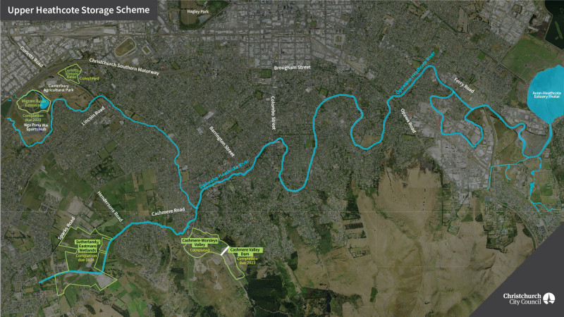
Upper Heathcote storage basins
A series of stormwater basins in construction in the upper Heathcote are helping to reduce flood risk, improve water quality and provide new public recreational spaces.
Changes caused by the earthquakes have increased flood risk along the Heathcote River. One of the key ways we can reduce flood risk is to store water during the peak of storm events, and slowly release the stored water after water levels downstream have dropped.
This results in a lower peak river level and reduces the risk of flooding for homes in the upper and mid-Heathcote which have an increased risk of flooding as the result of the earthquakes.
The flood management basins are combined with treatment wetlands to help improve water quality by treating stormwater runoff and sediments. The wetlands are also providing recreational areas with walkways and cycleways, grassland, wetland and forest habitats.
Upper Heathcote storage optimisation
To best manage the risk of river flooding and to optimise the benefits provided by the basins we’re installing automatic control gates to capture and release flood flows from the four basins.
Radio communications will also be provided to connect the system back to the control room at the Christchurch Sewage Treatment Plant.
Work is underway to integrate the four individual basin control systems in the Upper Heathcote River catchment and to minimise downstream flood levels for the design rainfall events.
Basins completed
Curletts Stormwater Basin
The Curletts Stormwater Basin at 201 Annex Road has been constructed. Capable of holding up to 130,000m3 of water, it is designed to provide additional flood protection up to a 1-in-50 year rainfall event.
It also treats water within Curletts Stream to remove sediment and contaminants to improve water quality in the stream and the Ōpāwaho/Heathcote River.
The basin is planted with wetland plants and the surrounding areas are planted extensively with native trees and shrubs. The area is accessible to the public from Mokihi Gardens and Annex Road, providing a lovely new space for walking.
Wigram East Basin
Wigram East Basin in Canterbury Agricultural Park has seen the lowering of a large area of the park for flood storage and created four hectares of wetland.
In a one-in-100 storm event, the basin can now store around 520 million litres of water, the equivalent of 236 Olympic-sized swimming pools, which means less risk of properties along the upper reaches of the Heathcote flooding.
The new wetland area provides habitat for a number of threatened species and also helps to clean the water as it leaves the basin and flows into the Heathcote.
As part of the flood protection work an extra kilometre of the walking track has been added to the park.
Ongoing works
Sutherlands Hoon Hay Eastman Wetlands storage basins
This 100ha stormwater facility is being constructed on a large area of low-lying land between Sparks, Sutherlands and Cashmere Roads.
During large flood events, two flood control gates will hold back approximately than 600,000 m³ of stormwater and will control its release into Cashmere Stream and the Heathcote River, helping to reduce flooding downstream.
In addition, wetlands will treat the stormwater run-off from the surrounding urban developments during normal rain events, and reduce sediment discharged from the Hoon Hay Valley.
The spring-fed Cashmere Stream(external link) runs through the facility, and this section of the stream is being enhanced as part of the project. This project is co-funded by Council and the Ministry for the Environment Freshwater Improvement Fund.
Across the whole facility, we are expecting to plant over 100,000 native tree species and 600,000 native plant species which will provide stormwater treatment and improve biodiversity and habitat. An extensive network of 11km of public access paths and tracks is being built which will provide a great space for the community to enjoy.
Construction is being undertaken in stages and will be progressively opened to the public over the next few years. The first stage of the facility south of Cashmere Stream is anticipated to be open to the public by the end of 2022.
Cashmere Worsleys flood storage basin
The Cashmere and Worsleys Valleys have been identified as good places for basins that will reduce flood risk to properties around the lower and mid-Ōpāwaho/Heathcote and improve water quality in Cashmere Stream and the Ōpāwaho/Heathcote River.
The first stage of the project is completed and is a structure in Cashmere Valley Drain, close to Worsleys Road, which can be shut to store water in the lower part of the valley. This will allow the lower valley to hold up to 500,000 m³ of water, and is designed to provide additional flood protection up to a 1-in-50 year rainfall event.
The valley has also been contoured to allow as much sediment as possible to settle out prior to water leaving the valley. This will improve water quality in Cashmere Stream and the Ōpāwaho/Heathcote River.
The second stage of the project will be to construct a dam in the upper part of the Cashmere Valley to provide an additional 300,000 m³ of water. This stage of the project will begin construction in the second half of 2022.
In addition to the flood control works extensive wetland planting is underway in both the upper and lower basins, along with construction of a network of paths for recreational use. Planting the valleys increases sediment capture while also increasing habitat diversity.

