We've had to change the way we approach safer speeds in Ōtautahi Christchurch and Te Pātaka o Rākaihautū Banks Peninsula.

National speed limit rules have changed
The Government’s new Land Transport Rule: Setting of Speed Limits(external link) came into effect on 30 October 2024.
The new rule means Christchurch City Council can no longer implement speed limit changes previously approved through the Safer Speed Plan we consulted on in 2023. This rule applies to all councils and road controlling authorities across the country.
With the new rule in place, we reversed the speed limits on the seven roads(external link) listed below before 1 July 2025:
- Western Valley Road between Christchurch Akaroa Road and 72 Western Valley Road.
- Gloucester Street between Linwood Avenue and Woodham Road.
- Ruru Road between Hay Street and Maces Road.
- Claremont Avenue between Paparoa Street and Tomes Road.
- Rose Street between Hoon Hay Road and Barrington Street.
- Lyttelton Street between Sparks Road and Rose Street.
- Colombo Street between Hunter Terrace and 129 Colombo Street.
There is no requirement to consult on the speed limit reversals on the specified roads listed in the rule. All new speed limits need to align with the rule. These reversals were approved by the elected Council on Wednesday 19 March 2025(external link).
Read our Newsline(external link) story for more information, or watch the decision(external link) being made.
Setting speed limits in future
Right now, we're prioritising implementing speed limit reversals and variable speed limits outside schools within the timeframes set out in the rule.
We're also developing a new process for changing speed limits in accordance with the requirements of the new rule. We can provide further information in future when this has been determined.
Safer speeds at schools
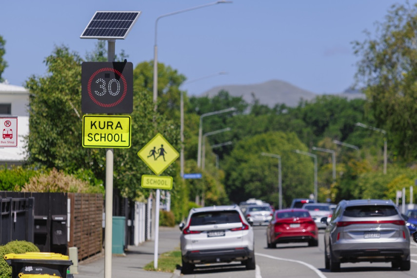
We’re lowering speed limits to make it safer for tamariki and rangatahi travelling to schools and kura across Ōtautahi Christchurch and Te Pātaka o Rākaihautū Banks Peninsula.
Over the next six months, Christchurch City Council is installing new variable 30km/h speed limit signage outside school gates. The variable speed will apply approximately 150 metres either side of each school gate.
In 2024, the Government introduced a new Setting of Speed Limits Rule 2024(external link). This rule requires us to implement variable speed limits of 30km/h during 'school travel periods' outside all schools.
‘Variable’ means the speed limit varies during the day. During school travel periods, the speed limit will be 30km/h. Outside these times, the usual speed limit will apply.
We’ve worked with schools and their communities to identify roads outside school gates and set school travel times.
On local neighbourhood streets, we'll use static variable signs that list the times when the 30km/h speed limit applies. On main connector roads, where there are typically higher vehicle volumes and speeds, we’ll install electronic variable signs.
School travel periods vary from school to school. We have allowed for a 45-minute window at the start and end of the school day for standalone schools. Where several schools are clustered together, the 30km/h speed limit will apply for a maximum period of one hour, so drivers can maintain a consistent speed when travelling through the area.
Some schools already have variable speed limits in place. Where these meet the requirements of the new rule, they will remain the same. For schools with a variable speed limit above 30km/h, signage will be updated to show the new limit by 1 July 2026.
Related news
News in brief from the Christchurch City Council meeting
Improvements on Moorhouse Avenue, speed limits around schools, tsunami sirens and Central City development contributions – here are the key decisions made at today's Christchurch City Council meeting.
18 Jun 2025
Call for views on Banks Peninsula speed limits
A proposed plan to lower speed limits on Banks Peninsula – including Akaroa and Lyttelton – is now open for public feedback.
28 Jan 2021
Have your say on drive to reduce speeds in Wigram
Wigram may be on the road to reducing speeds, with proposed changes open for community feedback.
20 Oct 2020