The timing and severity of sea-level-rise impacts will vary across the district, so we’re doing our adaptation planning in sections.
The final Coastal Hazards Adaptation Plan for Whakaraupō and Koukourarata was approved by the Council in March 2025.(external link)

Sign up to our Whakaraupō and Koukourarata Coastal Futures newsletter
Adaptation planning in Whakaraupō Lyttelton Harbour and Koukourarata Port Levy
We’re starting with communities in the Whakaraupō Lyttelton Harbour to Koukourarata Port Levy area.
We chose these communities because, as well as having places that are going to be impacted by coastal hazards in the short term, the area has a unique combination of factors that make it a great place to pilot our approach.
It’s a mix of an urban and rural environment, with built, cultural, economic, social and ecological interests. It also has infrastructure dependencies, such as the transport network, which has implications for the wider area.
Why we're doing this work
Between 2005 and 2020 we experienced 10 centimetres of sea-level rise, and it's virtually certain it will continue to rise over the 21st century.
In Ōtautahi Christchurch, we anticipate a further rise of 14 to 23 centimetres by 2050, and 38 to 100 centimetres by 2100 (compared to the 2020 sea level). Over the longer term, there's high certainty that the sea level is committed to rising for centuries to millennia to come due to deep-ocean warming and ice-sheet melt, and it will remain elevated for thousands of years.
For more information, see this report from the Intergovernmental Panel for Climate Change(external link).
Priority adaptation locations
The Coastal Panel has agreed on the priority adaptation locations (PALs) within the wider Whakaraupō Lyttelton Harbour to Koukourarata Port Levy area. The priority adaptation locations are the areas for which specific adaptation plans will be developed.
While we are planning for communities as a whole, public funding will be focused on public assets that contribute to the health, safety and wellbeing of communities. Therefore, priority adaptation locations were determined based on where coastal hazards are already impacting or would impact within the next 30 years, and where there is a high level of public asset exposure.
The priority adaptation locations are:
- Rāpaki
- Allandale
- Teddington
- Te Wharau Southern Charteris Bay
- Purau
- Koukourarata Port Levy
A network-wide approach to transport and marine infrastructure.
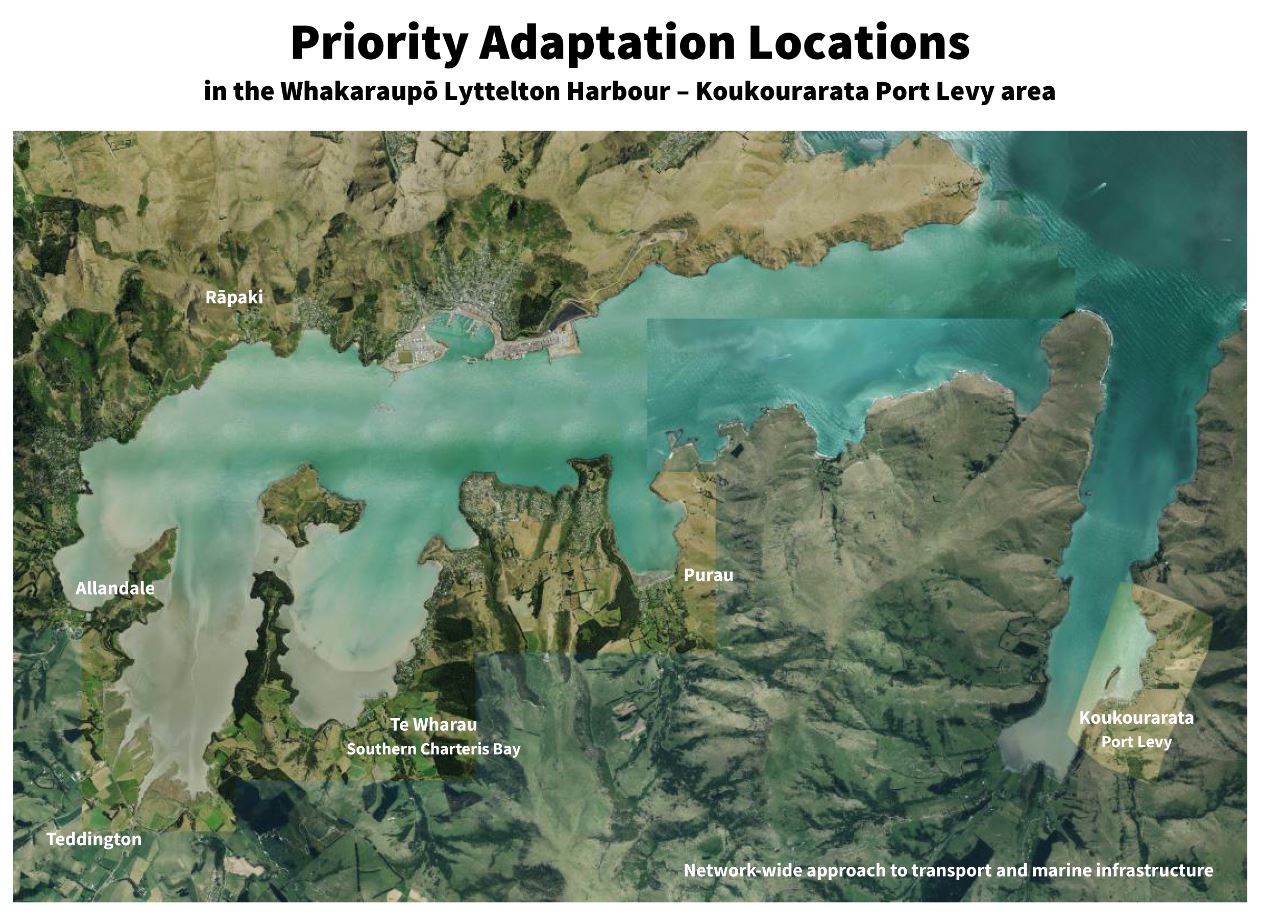
Map of the Priority Adaptation Locations
Community objectives
The Coastal Panel has also taken on board feedback from the wider community and developed community objectives which describe the outcomes that the Panel hopes to achieve through adaptation planning.
Adaptation options and pathways will be scored against these community objectives, as well as a range of other criteria, to assess how acceptable they are.
The wider community will also have further opportunities to provide feedback on adaptation pathways developed by the Coastal Panel later in the process.
The community objectives are:
- Community resilience
Foster the preparedness of communities (current and future) to determine how best to support themselves through times of disaster and disruption. - Community and culture
Retain a sense of community, social connectivity and sense of place by recognising the importance of heritage, identity, community spaces, places (such as parks and marae) and neighbourhoods. - Infrastructure
Ensure infrastructure, such as roads, jetties, waste, communications, electricity and water networks, are sufficiently resilient to support the health, safety and wellbeing of communities now and in the future. - Access to natural areas
Protect and enhance access to the land and the sea for mahinga kai, cultural activities, recreation, leisure, and enjoyment for current and future generations. - Environment and landscapes
Protect landscape amenity and protect the natural environment for mahinga kai, natural resources and native biodiversity.
To read about coastal hazards that may be exacerbated as sea levels rise, watch these videos.
You can explore the possible effects anywhere on our coastline in this interactive coastal hazards portal(external link).
Read our information brochures below to find out more about what the impacts could be for your area:
- Allandale [PDF, 2.7 MB]
- Koukourarata Port Levy [PDF, 1.7 MB]
- Lyttelton [PDF, 2.2 MB]
- Motu-kauati-rahi Cass Bay and Motu-kauati-iti Corsair Bay [PDF, 1.9 MB]
- Ōhinetahi Governors Bay [PDF, 1.1 MB]
- Purau [PDF, 2 MB]
- Rāpaki [PDF, 2.7 MB]
- Te Waipapa Diamond Harbour [PDF, 2.1 MB]
- Te Wharau Charteris Bay [PDF, 2.6 MB]
- Teddington [PDF, 1.6 MB]
Draft Adaptation Pathways Engagement Analysis
From October 2023 to January 2024, we asked for communities' feedback on the Coastal Panel's draft adaptation pathways for the Whakaraupō Lyttelton Harbour to Koukourarata Port Levy area, to check we were on the right track. The draft pathways outlined different ways to address the risks from coastal hazards in the six priority locations over time. Read the engagement analysis [PDF, 114 KB].
Coastal Adaptation Planning Engagement Report
From October to December 2022, we heard from the wider Whakaraupō Lyttelton Harbour to Koukourarata Port Levy communities about what they value in their coastal environments, what they want the future to look like, and what they didn’t want to see in the future.
This information is being used by the Council and the Coastal Panel to ensure local values inform the development of adaptation plans that allow communities impacted by coastal hazards to respond to changes over time.
To see the feedback we received from the wider community, read the full report [PDF, 1.8 MB] or the summary document [PDF, 471 KB].
Impacts of Coastal Hazards on Travel Report
In December 2021, as part of a scholarship project between the Council and the University of Canterbury, students undertook a survey to better understand communities’ risk tolerances and the impacts that potential loss of main road access could have on residents and essential services in the area. This information is also being used by the Council and the Coastal Panel while making adaptation plans for the area.
To see the results of this survey, read the full report [PDF, 1.7 MB] or the summary document [PDF, 91 KB].
A Coastal Panel has been appointed to lead adaptation planning in the Whakaraupō Lyttelton Harbour to Koukourarata Port Levy area. The Panel is a diverse group of 13 community and rūnanga representatives from the area, along with some city-wide representatives.
The Panel has been tasked with considering a range of views and interests drawn from engagements with the wider community and with mana whenua, rather than advocating for a particular point of view.
The Panel:
- Considers the cultural, social, environmental, built, physical and economic impacts of coastal hazards on communities across the Whakaraupō Lyttelton Harbour to Koukourarata Port Levy area.
- Considers the broad range of limitations (including technical), thresholds for change and community tolerance to risk, and agrees on potential adaptation pathways.
- Facilitates engagement with the wider community on these proposed pathways.
- Considers community input alongside expertise from technical and specialist advisors, in order to make recommendations to the Council on preferred options and pathways.
The Panel will provide recommended adaptation pathways to the Council for a final decision.
For more information about the Coastal Panel and its role, read the Coastal Panel Terms of Reference [PDF, 811 KB].
The Coastal Panel has the support and assistance of a Specialist and Technical Advisory Group (STAG) – a forum that’s made up of experts in their fields. The STAG members are able to provide information, advice and guidance to support the Coastal Panel's decision-making.
Coastal Panel members
- Aurora Smith
- Bex Gordon
- David Gregory
- Gina Waibl
- Ihorangi Reweti Peters
- Jillian Frater
- Jo Zervos
- Joan Blatchford
- Karen Banwell
- Luana Swindells
- Makarini Rupene
- Manaia Cunningham
- Paul Dahl
- Tayla Nelson-Tuhuru
Specialist and Technical Advisory Group (STAG) members
- Andrew Hensley, Council, Transport
- Eric Banks, Council, Parks
- Geoff Butcher, Butcher Partners, Economist
- Jesse Dykstra, Council, Technical Design
- John Benn, Department of Conservation
- Justin Cope, Environment Canterbury
- Lucy D’Aeth, Te Whatu Ora
- Michele McDonald, Council, Three Waters
- Nathan Harris, Council, Consents and Planning
- Nicholas Head, Council, Ecology
- Nicola Rykers, Maahanui Kurataiao Ltd
- Tom Parsons, Council, Three Waters
The Coastal Panel has developed draft adaptation pathways for the six priority locations across Whakaraupō and Koukourarata.
Read our brochures below to find out more about the draft pathways for each location.
You can also read and contribute to our story-map, Moving around in the future(external link).
Brochures:
- Rāpaki [PDF, 1.7 MB]
- Allandale [PDF, 2.1 MB]
- Teddington [PDF, 1.1 MB]
- Southern Te Wharau Charteris Bay [PDF, 1.9 MB]
- Purau [PDF, 1.8 MB]
- Koukourarata [PDF, 1.4 MB]