Deciding the future of baches at Taylors Mistake and bays

Council staff are preparing for city-wide consultation on the future of baches on public land at Taylors Mistake, Hobsons Bay and Boulder Bay.

Project status: Decision made
Open for feedback: 3 October 2018 to 21 October 2018

Share this

'Rotten Row' at Taylors Mistake


Feedback on the discussion document has now closed

You can read the report including all feedback and analysis(external link) (page 875). Consultation on the proposed option ran between 23 November 2018 and 14 January. You can read more here - ccc.govt.nz/baches(external link). A final decision om the Hearings Panel's recommendations will be made by Council on 11 April, 2019. When a meeting agenda is available you can read it here


Council, as the land owner, needs to decide whether all, some, or none of the baches at Taylors Mistake, Hobsons Bay and Boulder Bay should be offered a licence to occupy its public road reserve, and if so, under what conditions.

The question of what should be done about the baches has been considered for many years. However, because of changing circumstances, no final resolution has ever been reached. A decision would give bach owners, the Council and others in the community certainty about the presence of the baches and how they might be used today and in the future.

A lot of information will be considered in making this decision, so to help increase public understanding of the issues, we are taking a two-stage approach. This first stage is about making available good quality, technical information. Feedback received during this discussion phase will contribute to developing the priorities for the project. Formal consultation on options will happen later this year.


Background

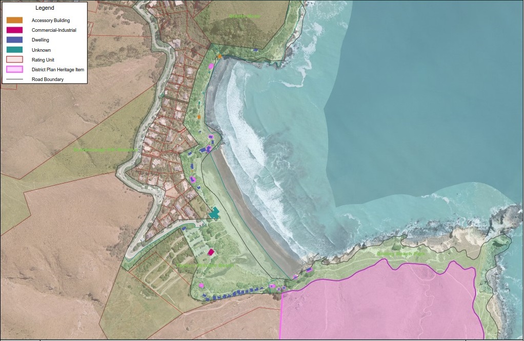
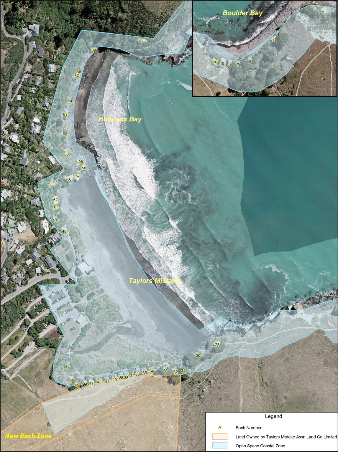
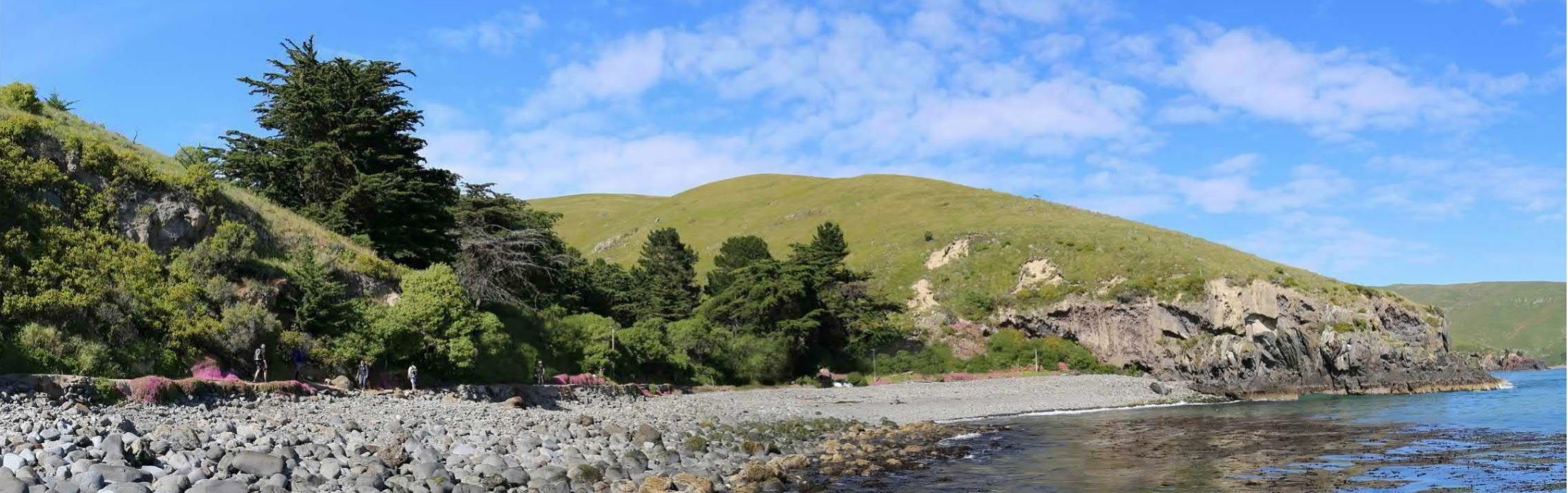
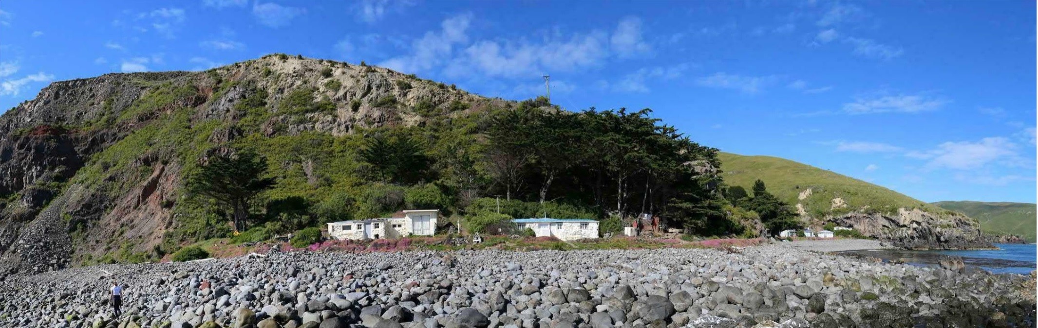
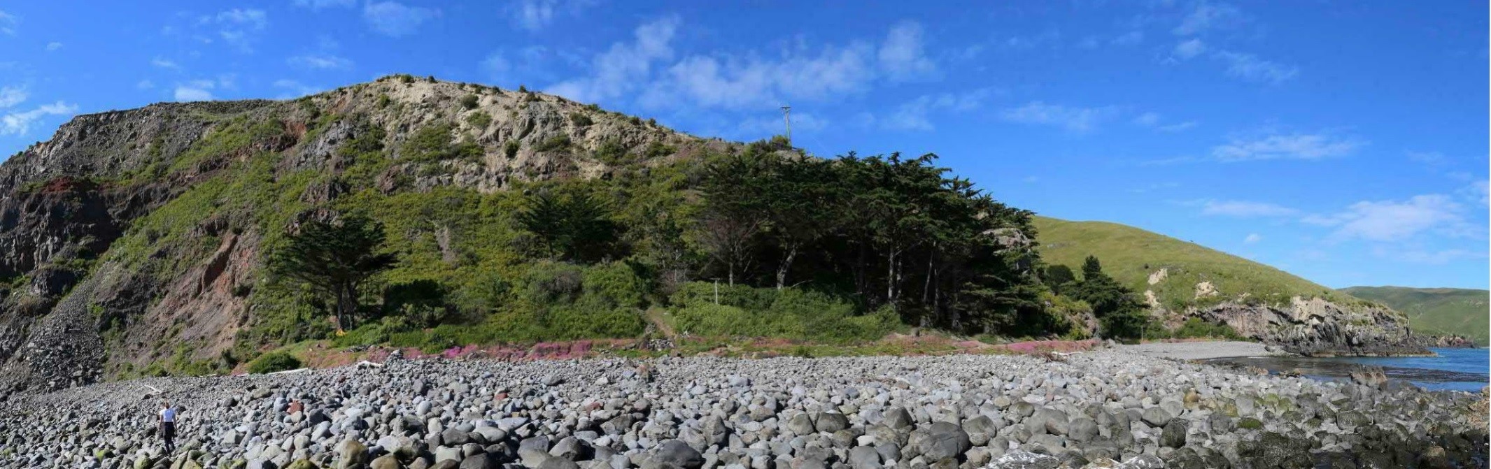
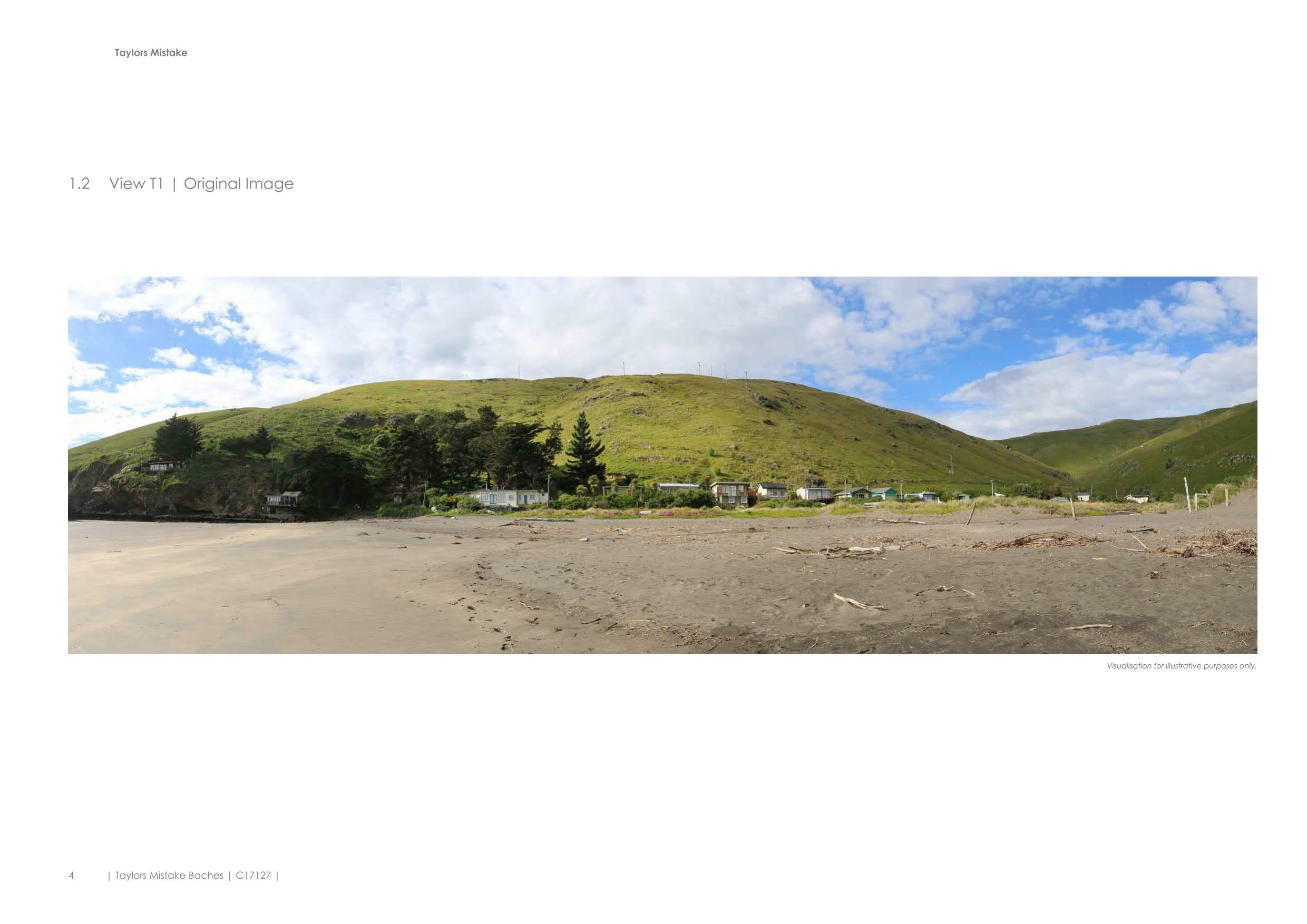
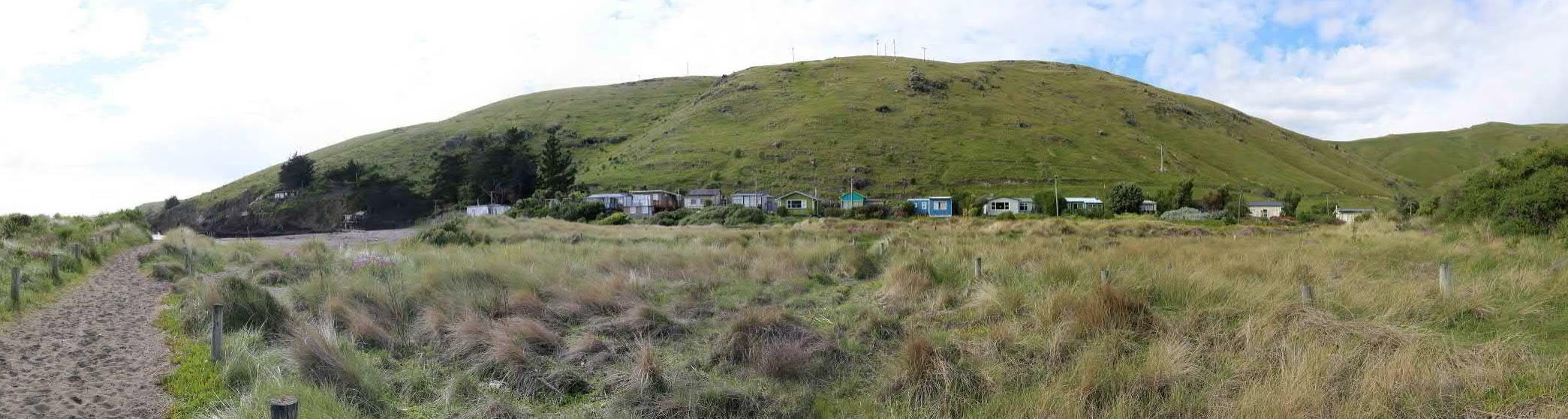
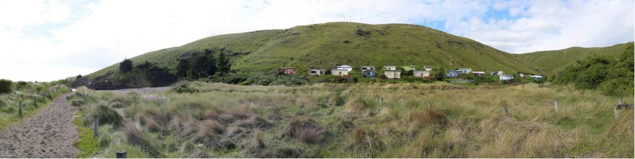
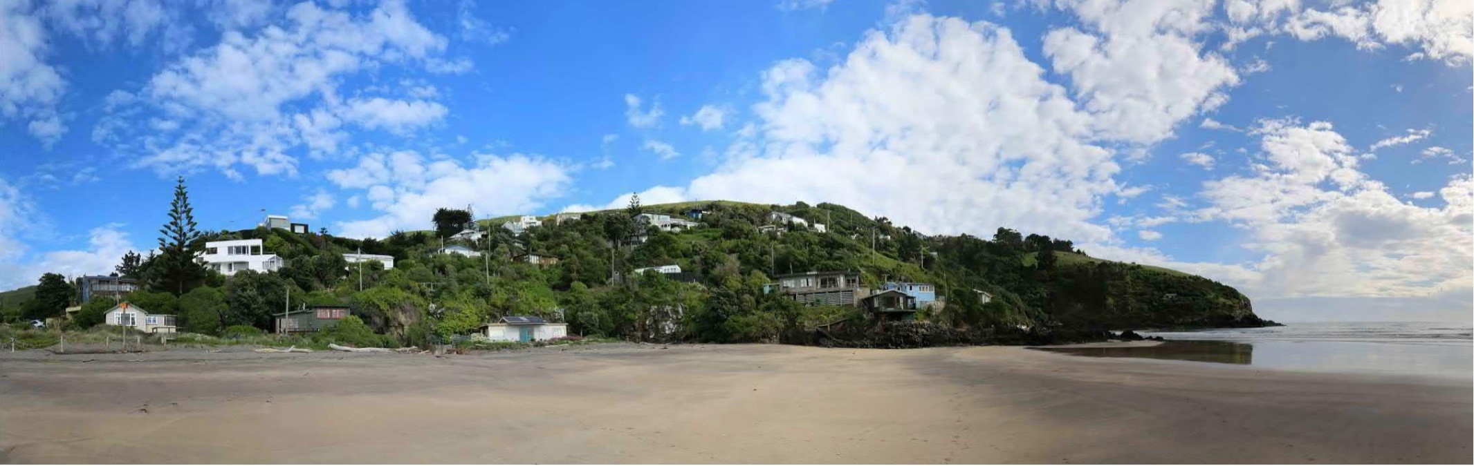
Privately owned baches have been part of the landscape at Taylors Mistake, Hobsons Bay and Boulder Bay since the early 1900s. In total, there are 45 baches currently occupying public land - 27 at Taylors Mistake, 9 at Hobsons Bay and 9 at Boulder Bay.

Christchurch is not the only council grappling with the issue of privately owned baches occupying land set aside for public use. Many baches dot the New Zealand coastline, riverbanks and lake shores on land managed by territorial authorities and the Department of Conservation (DOC). To date there has been a range of responses to this issue, with mixed results.

Bach image

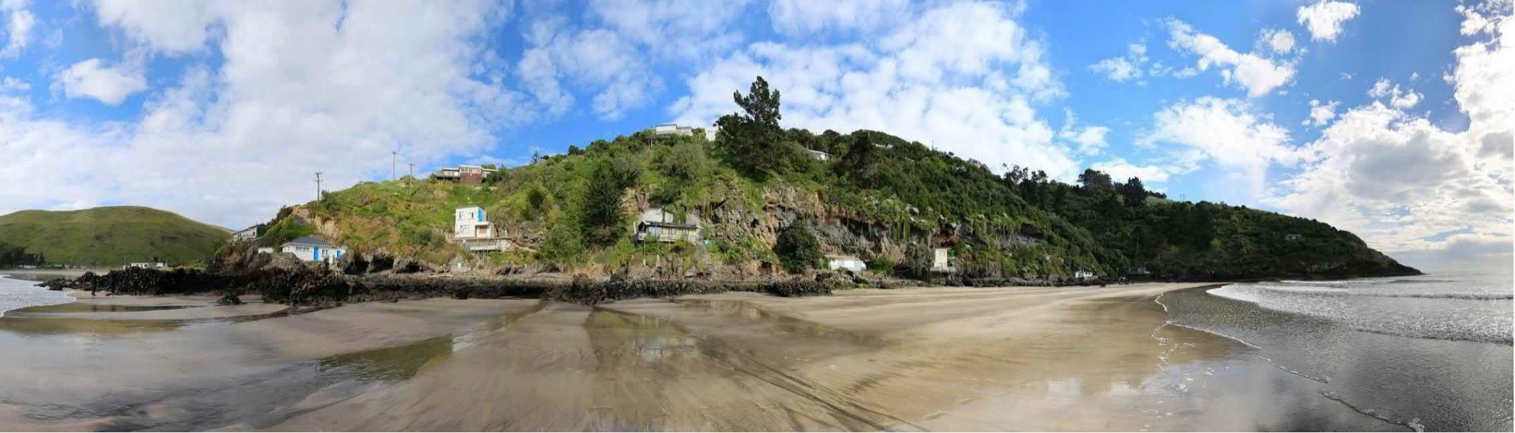
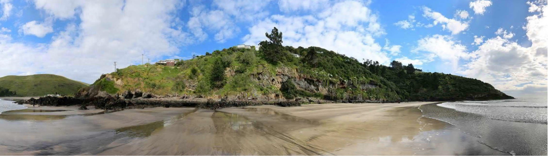
First baches were established in caves around the coastline

How the baches came to be

The first European land owner at Taylors Mistake, Hobson Bay and Boulder Bay was the Canterbury Association. This land was subdivided in 1851, with a one-chain strip of land from the high tide mark reserved as road. The road reserve was later extended, with the Sumner Borough Council having full ownership rights.  

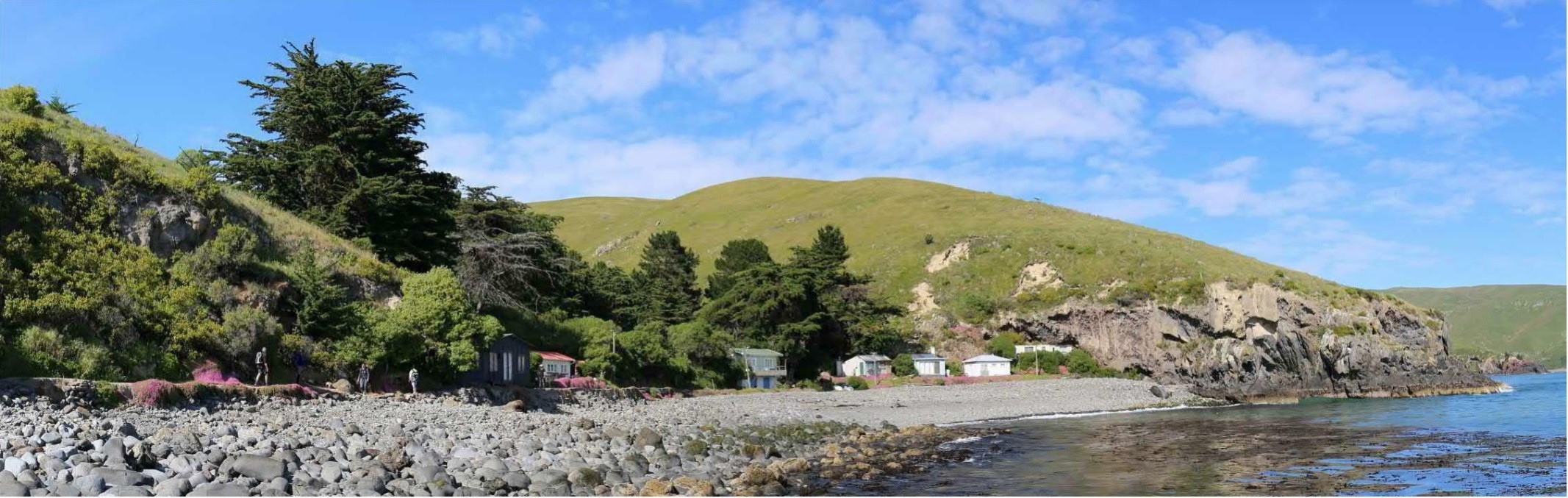
The first baches appear to have been established in the early 1890s, built into caves along the foreshore. In 1911, the Sumner Borough Council resolved that cave (bach) dwellers must pay 20 shillings per year, on the understanding that the Council reserved the right for the public to access the land at all times.

The first hut in the Taylors Mistake area known as ‘The Row’, or ‘Rotten Row’, appeared in 1913 and by 1920 another dozen or so baches had been built there. Between 1920 and 1930 more baches were built and the older baches were renovated. By World War II there were 72 baches on the foreshore between Hobsons Bay and Boulder Bay. The Sumner Borough Council stopped issuing licences for new baches in the early 1940s.

During the war, the New Zealand Army took over Taylors Mistake and there was no public access to the area. Some cave baches were destroyed by vandals during this time. The Sumner Borough Council amalgamated with the Christchurch City Council in 1945, after which no new baches were built, although owners were allowed to rebuild baches damaged by fire or land slips until about 1968.

First removal of baches

Waste disposal was always problematic and in the early 1970s the Council decided that baches without a properly fitted toilet had to be removed. Sixteen baches (mainly cave baches) between The Row and Boulder Bay were demolished and owners were not allowed to rebuild. Similarly, baches that burned down or were damaged by land slips were not allowed to be rebuilt.

Offer for exchange of land

In 1992, the Council established a working party to which all interested parties were invited to contribute. The preferred option was for some baches to remain and some to be removed and given the option to relocate to land behind ‘The Row’ (the new bach zone).

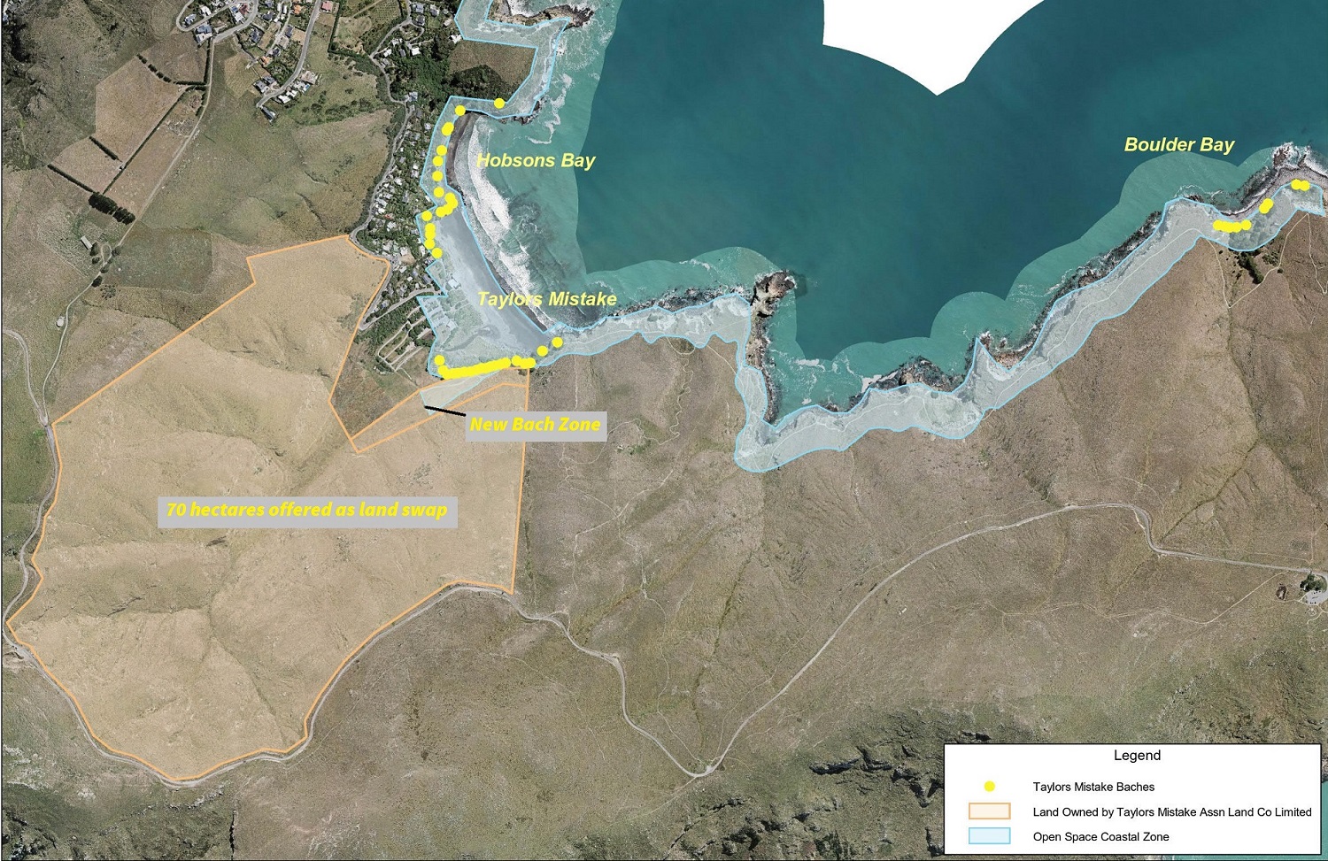
Bach owners formed the Taylors Mistake Land Company and offered the Council 70 hectares of land it owned in the valley behind the bay, in exchange for the new bach zone.

In May 1993, the Council considered the working party’s report and resolved that it be accepted as the basis for resolving the bach issue.

Subsequently, a change to the City Plan (now the District Plan) was proposed to create a Taylors Mistake Residential Bach Zone (on the new bach zone) and to zone the foreshore road reserve as Esplanade Reserve, allowing for 15 baches to be relocated to the new bach zone and 33 baches to remain on public land on the esplanade reserve.

Plans to change the status of the road reserve was publicly notified. A commissioner appointed to hear submissions on the plan change recommended that the road reserve should be rezoned to allow some baches to remain. The commissioner’s recommendation was adopted by the Council in December 1993.

The Council notified its proposed City Plan in June 1995. The Plan made provision to stop the road reserve, but not for the baches to remain.

Submissions on the City Plan were heard by a commissioner, who recommended, in December 1998, rezoning the coastline from Hobsons Bay to Boulder Bay, to allow the baches as permitted activity and create the new bach zone at Taylors Mistake.

The Council adopted the commissioner’s recommendation on 22 March 1999 and the zone changes were publicly notified in May. This was challenged in the Environment Court by Save the Bay Ltd (a local resident’s group that opposed the baches remaining), a Taylors Mistake resident and The Royal Forest and Bird Protection Society.

In 2003 the Environment Court supported the commissioner’s recommendation and the City Plan was amended to allow 31 baches to remain. Fourteen baches from The Row and Hobsons Bay were to be relocated or rebuilt in new bach zone at Taylors Mistake.

In 2007, a staff report recommended that the Council require bach owners to take steps to create the bach zone, that baches unscheduled (not permitted) in the City Plan be removed and that the Council agree to begin negotiations with those owners of scheduled (permitted) baches for a licence to occupy the road reserve.

However, the Council instead resolved to consult with Ngāi Tahu, discuss the proposed licence with bach owners and to continue discussions with Save the Bay. The Council asked for a staff report on other instances where private structures are on legal road reserve within the Christchurch city district and a report on the heritage status of the baches.

In 2010, after receiving a further staff report, the Council resolved to implement the 2003 Environment Court decision. The Council asked bach owners to immediately take steps to issue titles in the new bach zone, to transfer the 70 hectare adjoining land owned by Save the Bay to the Council for use as a recreation reserve and to remove all unscheduled baches. The Chief Executive was authorised to negotiate the terms and conditions of licences.

The Canterbury earthquakes of 2010 and 2011 affected both the physical and planning environment, which led to the Council once again having to reconsider its position on the future of the baches.

Recent decisions

In April 2011, a Taylors Mistake resident lodged an application in the Environment Court for enforcement of the City Plan provisions, seeking immediate removal of the 14 unscheduled baches. In June of that year, several bach owners applied for existing use rights for their baches, which was granted in September 2011.

In 2015, a Government appointed independent hearings panel reviewed the Council’s District Plan (previously the City Plan). The panel noted that the baches did not have a licence to occupy Council-owned land and that the Council was reviewing the arrangement. The panel did not want its decision to be seen as determining the appropriateness of licencing the baches, as this was outside of its jurisdiction.

In 2017 a working group was appointed by the Council to progress the review of the previous licence decisions and make recommendations to the Council on a preferred option for the future of the baches and in turn whether the offer of a licence to occupy the road reserve was still appropriate for either all, some or none of the baches. The 2010 decision was rescinded to allow the review to begin afresh.

Key points in the history of the baches

1851
  • Road reserve first established and later extended
1890-1945
  • First baches established in caves
  • 72 baches established by start of WWII 
1945 - 1968
  • No new baches allowed
  • Substantial renovations permitted until 1968
1970s
  • Baches without properly fitted toilets are demolished
1990s
  • Taylors Mistake Land Company proposes land swap
  • Discussions back and forth over changes to City Plan
  • Area recognised as Historic Places Trust Heritage Area
2003 - 2006
  • Environment Court decision
  • City Plan amended to allow 34 baches to stay and 18 to move to new bach zone
2007 - 2009
  • Council consult with Ngai Tahu
  • Council requests report on other local privately owned buildings occupying public land
  • Council requests report on heritage status of baches
2010
  • Council resolves to implement City Plan
  • Council asks for titles to be issued in new bach zone
  • All unscheduled baches expected to be removed once new bach zone is active
  • Council Chief Executive authorised to negotiate licences for baches
  • 2010 and 2011 earthquakes
2011 - 2014
  • Taylors Mistake resident applies to Environment Court to have City Plan enforced and 14 baches removed
  • Existing use rights granted for bach owners
2015
  • Hearings panel reviews District Plan
  • Panel decides ‘prohibited' status is appropriate for baches
  • Panel seeks management framework for the Council to manage the impact of activities on the environment
  • Panel notes it is for the Council to resolve the issue of licencing of baches
2017
  • Council appoints Working Group to review and make a recommendation on the future of the baches and any licences offered
2018
  • CCC staff begin discussions with bach owners and other interested parties
  • Community information sessions (13, 15 October)
  • Staff prepare for community consultation, based on a range of options
  • Staff ask Council to approve consultation and establishment of a hearings panel (8 November)
  • If approved, consultation begins 9 November
  • Summary of submissions prepared
2019 - proposed
  • Hearings Panel convened to hear submissions
  • Recommendation to Council, taking public feedback and submissions into account
 

Maps of bach areas and relevant zones within the district plan

[section]647[/section]

Points to consider

As the land owner, the Council has several aspects it must consider in coming to a decision about the future of the baches. These include:

Bach example image

Some baches are exposed to natural hazards

Public access – to the coast

There are national, regional and district policies on maintaining and improving public access to the coast, which recognise the need for public open space within coastal areas, and where possible to enhance public access.

Public access – to the road reserve

All the baches are on land designated as public road reserve. A public road reserve is meant to be accessible by members of the public. The Council can’t grant a licence for a structure on a road reserve if the structure unreasonably impedes the public’s right of access.

Natural hazards

Geotechnical work has identified that some baches are at a moderate to high risk from cliff collapse or rockfall. The baches are all within hazard management areas under the District Plan.

Heritage significance

Thirteen baches are listed as a Historic Area by Heritage New Zealand Pouhere Taonga. Fourteen baches are scheduled in the District Plan as Significant Heritage Items, and Council staff consider that others not currently scheduled, would meet the threshold to be considered for scheduling.

Heritage staff also consider some baches would have value as part of a potential heritage area in the District Plan.

Cultural significance

Some of the baches are in areas designated in the District Plan as having cultural significance to local Māori. These are Ngā Tūranga Tupuna (landscapes of cultural significance) and Ngā Wai (bodies of water). Ngai Tuahuriri Runanga have provided a preliminary view that the baches should remain for the lifespan of the current owners and then be demolished.

baches example image

Baches have an impact on coastal character

Coastal landscape and character

Another consideration is how the baches relate and contribute to the coastal environment, and whether restoration of natural character is desired and how the presence of the baches helps or hinders such an outcome. The public road reserve the baches are on traverses areas designated as High Natural Character in the Coastal Environment and as Outstanding Natural Feature or Landscape. All the baches are in an area designated as High Natural Character in the Coastal Environment and many are also in an area designated as Outstanding Natural Feature or Landscape.

Summary of technical information for each bach

The table below has all of the main technical information, including that most relevant under the Christchurch District Plan. You can view the District plan in more detail.

Geotechnical hazards

Following the Canterbury Earthquakes, three slope stability hazards have been identified within the Port Hills:

•              Rockfall (or boulder roll)

•              Cliff collapse

•              Mass movement

These hazards may occur in isolation, or as a combination, depending on the trigger. Triggers include: Earthquakes; Rainfall; Human activity (water runoff, earthworks); Weathering and erosion; or They just happen with no obvious trigger (gravity).

These hazards pose a potential risk to life, property and infrastructure in some areas. Although these hazards existed before the 2010 – 2011 Canterbury Earthquakes, their extent and severity is now significantly greater. In addition to landslides, landslips (soil material) will continue to occur, generally as a result of long duration or high intensity rainfall events.

Since the earthquakes, GNS Science has worked to assess the risk these hazards pose in residential areas of the Port Hills. The risk is looked at in terms of the likelihood of the hazard occurring, in combination with the consequence if it did.

This column identifies whether each bach is within a hazard management areas under the Christchurch District Plan. These are: Rockfall Management Areas (1 and 2), Cliff Collapse Management Areas (1 and 2); Liquefaction; and “Remainder of Port Hills and Banks Peninsula Slope Instability Management Area”. Also reported is the results from site specific geotechnical assessments (including options for viable mitigation works) undertaken as part of the District Plan Review

Information is also provided on the slope-instability risk modelling analysis undertaken by GNS Science following the earthquakes of 22 February 2011.  The GNS approach uses a numerical assessment of probabilities (how likely it is that some event will happen) allowing the regulators and the community to determine an acceptable, tolerable and intolerable level of risk. For a risk to be acceptable, the consequences and likelihood of it occurring are low. A tolerable risk has a slightly higher level of risk than acceptable risk. And an intolerable level of risk occurs when the level of risk becomes unacceptable.  The GNS Science reports make extensive use of terminology which expresses risk as probabilities such as 1 in 10,000 per year (one person in every 10,000 at risk of being killed each year).  You can read more information on the GNS risk assessment.

Natural character, landscape and Ngai Tahu values              

This column identifies whether each bach is within one of the following mapped areas in the District Plan: High Natural Character; Outstanding Natural Feature or Landscape; or the Ngā Tūranga Tūpuna overlay. 

The Outstanding Natural Feature or Landscape overlay describes where a particular protection has been applied to land that retains a high level of natural features, patterns and processes and associative, sensory or biophysical values, (and are identified as 'Outstanding' within the District Plan). For more information, refer to Chapter 9 of the District Plan, including section 9.2 and the Schedules at Appendix 9.2.9.2.1(external link) and 9.2.9.2.2(external link).

The Area of at least High Natural Character in the Coastal Environment identifies parts of the coastal environment that are less modified by human activities and is subject to particular protection provisions to retain the natural character of the coastal environment and to protect it from inappropriate subdivision, use, and development. For more information, refer to Chapter 9 of the District Plan, including Section 9.2 and the Schedule at Appendix 9.2.9.2.8.

Ngā Tūranga Tūpuna (explanation of term refer to 1.2.13 - Sites of Ngāi Tahu Cultural Significance). For more information refer to Chapter 9.5 and in particular Rule 9.5.3 g and i(external link), for an explanation of how the provisions work and Schedule 9.5.6.3(external link) for the list of Ngā Tūranga Tūpuna.

Ngā Wai (including Coast ID 78 and Coast ID 96) (explanation of term refer to 1.2.13 - Sites of Ngāi Tahu Cultural Significance). For more information refer to Chapter 9.5 and in particular Rule 9.5.3 h and i, for an explanation of how the provisions work and Schedule 9.5.6.4 for the list of Ngā Wai.

Historic heritage value             

The first column identifies whether each bach is scheduled as a heritage item in the Christchurch District Plan. Comment is also provided as to whether, based on a recent heritage assessment undertaken by Christchurch City Council staff, a bach which is currently not scheduled as a heritage item under the Christchurch District Plan would meet a threshold of heritage significance to be considered for inclusion (as part of a future Plan Change and/or District Plan review).

The second column records the result of an assessment by Council’s heritage staff as to whether the relevant bach could be part of a heritage area, if the Council was to consider inclusion of identified heritage areas in the District Plan through a future Plan Change process. This column also identifies if baches are included in the Heritage New Zealand Pouhere Taonga (HNZPT) existing Rotten Row Historic Area.

NOTE: This table is no longer available but the information can be viewed here (external link)

Visualisations of the three bach areas 

Licence considerations

If a licence is granted for bach owners, there are again a number of considerations when deciding the licence conditions.

Should the licence period be long term or short term, or should it include a ‘sunset’ (removal) clause?

A licence could be for 5, 10, 35 years or another defined period. The previous draft licence was for 10 years, with a renewal option.

One reason for bach retention may be to maintain heritage values. There is some concern that short term licences may be a disincentive for owners to invest in maintaining their baches. It is highly desirable that maintenance of heritage is undertaken in a cost effective manner that does not impose costs on ratepayers. A licence period of no greater than 35 years is required, to avoid potential sub-division of land (Resource Management Act(external link)).

Should bach owners be able to transfer ownership?

This question looks at whether the baches should be able to be sold on the open market or transferred to other parties such as family members.

What is the significance of natural hazards for licence content?

Occupancy levels affect the hazard risk. The Council could, for example, refuse to offer any licence to occupy a bach if the occupants would be at a risk that the Council considers too high.  Also, if the hazard scenario changes, can be mitigated or increases in the future, provision to change or withdraw a licence may be desirable.  Hazard risk may affect subletting or rental potential.

Should the licence ensure bach heritage character is maintained and the local environmental protected?

The licence may need to include provision for ensuring the existing heritage character is maintained.   Bach owners could also be encouraged to contribute toward environmental stewardship and landscape enhancement. Experience from Rangitoto Island has shown that where baches are retained but not used, they rapidly fall into disrepair and become dilapidated. This can be because of lack of maintenance due to a lack of funding.

Should the licence ensure bach use is for holiday or temporary accommodation only?

The licence needs to define temporary occupation. Council may consider that continuous residential accommodation is not an appropriate use of these structures.

Can or should the general public have opportunity to enjoy a bach experience?

Baches could provide community benefit by being available for hire. This may not be feasible for some baches, where there is hazard risk. The Department of Conservation policy for consented private baches on public land requires bach owners to make their baches available for public use. Owners are permitted to charge a reasonable fee for use.  See the Canterbury (section 3.11.4) and West Coast Conservation Management Strategies for examples of general policy. There may be significant benefits in allowing subletting:

  • It may enable the public to experience a bach lifestyle and heritage values.
  • Any extra return from rentals could be used for environmental and heritage protection and upgrading of the area. 

Should the Council charge a licence fee and how should it be calculated?

Any bach management or administration costs incurred by the Council could be compensated for by a fee or some other mechanism.  The ‘gift’ of 70 ha in the upper Taylors Valley may influence this decision. In 2010 there was a significant difference between the Council’s proposed fee and the bach owners’ proposed fee.

Glossary of terms

Bach

The baches referred to in this document are small dwellings that were built at various times between 1890 and 1940 along the coast at Taylors Mistake, Hobsons Bay and Boulder Bay. They were built on public road reserve land, also known as the Queen’s Chain.

Consultation

A specified period of time, usually a month, during which the Council makes information available to the public on a particular issue or proposed plan of work and asks for feedback on it. Feedback will be used to help inform decision making, alongside technical information and advice.

Esplanade reserve

Land next to the sea, a river or a lake that is held by the Council as a reserve for conservation, public access or public recreation purposes.

Hazard Management Area

An area defined in the District Plan as requiring special management because of natural hazards such as slope movement, rock fall, cliff collapse, landslide, coastal inundation, flooding and/or liquefaction. These areas generally exclude certain activities, such as building, or allow certain activities under strict conditions.

Hearings panel

A Hearings Panel made up of elected Councillors and Community Board members may be established so submitters can present their submission in public. A hearings process allows more time for complex issues to be discussed. After considering all the submissions the hearings panel makes a recommendation to the Council.

Heritage Area

Heritage New Zealand Pouhere Taonga gave Historic Area status to the part of Taylors Mistake where the ‘Rotten Row’ baches are in 1995. It said the baches, built from cheap materials, represented an ‘indigenous’ architectural style that was the result of ‘Kiwi ingenuity’. It also said they illustrated ‘a New Zealand way of life’. HNZ said the Row baches, as a group, have historic, architectural, aesthetic and cultural heritage value.

Heritage schedule

A list in the District Plan of items with historic heritage significance.

Licence to occupy

A licence issued by the Council to a bach owner that allows the bach to remain on public reserve land, under certain conditions of use and for a set period of time.

New bach zone (Coastal Bach Overlay Area)

A parcel of land at Taylors Mistake, owned by the Taylors Mistake Bach Owners Association. It is designated in the District Plan as an area where up to 18 baches may relocate to or be rebuilt on.

Ngā Tūranga Tupuna

Landscapes of cultural significance to Māori.

Ngā Wai

Bodies of water, including coastal areas that are of cultural significance to Māori.

Notified

A public notice published in the newspaper to advertise a proposed plan and gives people an opportunity to lodge a submission in support of or in opposition to the proposal.

Managed removal

A plan, negotiated between the Council and the bach owners, to remove baches from their current site.

Managed retention

A plan, negotiated between the Council and the bach owners, to keep baches in their current locations.

Road reserve

Road reserve is a legal term sometimes also known as a ‘paper road’ or the Queen’s Chain, when on the coast or alongside a river or lake. Road reserve is not intended as a road for vehicles but is land that set aside as reserve to enable public access.

Scheduled heritage items

Items of significance to the district are listed in the schedule of significant historic heritage in the Christchurch District Plan and are protected by the rules in the Plan. Some of the baches at Taylors Mistake are scheduled in our Plan.

The Row (Rotten Row)

A row of 13 baches, constructed from a variety of cheap building materials, which stretches from the Taylors Mistake car park to the strangely shaped rock known as the Crocodile. Most of these baches were built in the 1920s.

Decision making process

Following this initial information sharing, staff will gather feedback to help prepare the formal consultation material, which is scheduled to start mid-November 2018. Council will meet in early November 2018 to approve the consultation and decide whether a hearings panel is established.

Submissions received during consultation will be analysed and reported on as part of a staff recommendation to the Hearings Panel, if established, in early 2019. The Hearings Panel would make a recommendation to the Council for a final decision.

Weighing up the options

Detailed options for the future of the baches are still under review, but in broad terms are likely to include:

  • An option where a licence is offered to all bach owners (managed retention).
  • An option, or options, where a licence is offered to some bach owners and the rest are removed (managed retention and removal).
  • An option where no licence is offered to any bach owner and all baches are removed (managed removal).

For each of these options there are many considerations, such as:

  • Risk to those occupying the baches from natural hazards
  • Effect of the bach on the coastal landscape
  • Effect of removing a bach on heritage values
  • Provision of public access if a bach stays


Public information sessions

An informal opportunity to find out more about the project – drop in any time.

Matuku Takotako: Sumner Centre

14/16 Wakefield Avenue, Sumner
Saturday 13 October
9am–11am

Woolston Community Library

689 Ferry Road, Woolston
Monday 15 October
5pm–7pm

Location

Share this

Who to contact

How the decision is made

  • Decision made

Takiuru ki ā mātou ratonga
Log in to our services